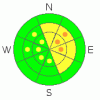
BOTTOM LINE
Danger by aspect and elevation on slopes approaching 35° or steeper.
(click HERE for tomorrow's danger rating)
|
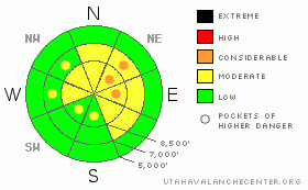
Danger Rose Tutorial
|
The overall danger is level 2 or Moderate in the backcountry around Logan, and heightened avalanche conditions exist on drifted slopes and in exposed terrain. Avoid steep slopes with significant recent deposits of drifted snow where you could trigger wind slab and perhaps more dangerous hard persistent slab avalanches in places. Continue to practice safe travel protocols and evaluate the snow and terrain carefully in the backcountry, especially on recently wind drifted slopes... |
|
|
CURRENT CONDITIONS |

|
We found postcard quality shallow powder riding conditions yesterday, with the best conditions in sheltered terrain. You still feel the crusts in places. The Tony Grove Snotel at 8400' reports 4 degrees and 94 inches of total snow on the ground, containing 142% of normal water content for the date. This morning, the wind remains light and easterly, with low single digit hourly averages recorded overnight at the Hwy 89 Logan Summit weather station. |
|
|
RECENT ACTIVITY |

|
Monday afternoon, we remote triggered a fairly large hard slab avalanche from around 40 feet away on our way down the lower Steam Mill/White Pine ridge. The avalanche included a fair amount of freshly drifted snow but it also stepped down into old snow well below the thick and solid MLK rain-crust, running on the surface hoar/ facet layer that was buried and preserved a month ago on 1/8! Yesterday, we could see evidence of a few natural wind slab avalanches from overnight Mon/Tue in the Wellsville Range, and a pretty one under the cornice on Cornice Ridge...
Check our backcountry avalanche list.... HERE |
|
|
THREAT #1 |

|
| WHERE |
PROBABILITY |
SIZE |
TREND |

|
|
|
|
| |
|
|
Over the next
24 hours.
|
|
|
You could encounter wind slabs from Monday's storm in exposed terrain today, and although stubborn, some of these could still be sensitive to your weight. You might find dangerous hard wind slabs mainly on slopes facing northeast through southeast. A few inches of fresh snow toward the end of the storm obscured obvious drifts under a bit of powder. Watch for and avoid wind drifts on steep slopes off the lee sides of ridges and sub-ridges. Be wary of other places where sustained west and north winds deposited drifted snow, like under cliff bands, around rock outcroppings, along gully walls, or in scoops or depressions. Cornices could break further back and be larger than expected, and falling cornice chunks might trigger wind slab avalanches on slopes below. |
|
|
THREAT #2 |

|
| WHERE |
PROBABILITY |
SIZE |
TREND |
|
|
|
|
| |
|
|
Over the next
24
hours.
|
|
|
The recent load on drifted slopes may be enough to reactivate buried persistent weak layers consisting of surface hoar or sugary faceted snow. The avalanche we remote triggered Monday is proof of the pudding, and clearly the serpent is still lurking in places. Dangerous and destructive hard slab avalanches involving old snow and in the 1 to 3 foot-deep range are possible on slopes with significant recent wind loading and existing buried weak layers. Other than the presence of recently drifted snow, there may be no prior warning signs, but remember that collapsing is a major red flag. You might trigger a persistent slab avalanche remotely or from a distance, and hopefully not from below.... |
|
|
MOUNTAIN WEATHER |

|
The cold northwest flow will continue through tomorrow, and we'll see increasing clouds today, with a chance for a little snowfall this afternoon. Mountain temperatures will stay on the cold side today, with a high of about 10 degrees forecast for 8000'. The high pressure system currently centered over the eastern Pacific will push over Utah beginning Friday, with inversions in the valleys and fair weather in the mountains a good bet for the weekend. |
|
|
GENERAL ANNOUNCEMENTS |
You can view a photo summary of last year's avalanche activity in the Logan Area HERE
Join the friends of the Utah Avalanche Center in Logan on facebook. Click HERE
I will update this advisory in the mornings on Mondays, Wednesdays, Fridays, and Saturdays, and on other days if backcountry avalanche conditions warrant...
You have the opportunity to participate in the creation of our own community avalanche advisory by submitting avalanche and snow observations. You can also call us at 801-524-5304 or Toby at 435-757-7578, or email by clicking HERE
Donate to your favorite non-profit – The Friends of the Utah Avalanche Center. The UAC depends on contributions from users like you to support our work.
This advisory is from the U.S.D.A. Forest Service, which is solely responsible for its content. This advisory describes general avalanche conditions and local variations always occur. |
|
|
This information does not apply to developed ski areas or highways where avalanche control is normally done. This advisory is from the U.S.D.A. Forest Service, which is solely responsible for its content. This advisory describes general avalanche conditions and local variations always occur. |
|
This advisory provided by the USDA Forest Service, in partnership with:
The Friends of the Utah Avalanche Center, Utah Division of State Parks and Recreation, Utah Division of Emergency Management, Salt Lake County, Salt Lake Unified Fire Authority and the friends of the La Sal Avalanche Center. See our Sponsors Page for a complete list. |
