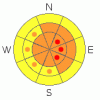
BOTTOM LINE
Danger by aspect and elevation on slopes approaching 35° or steeper.
(click HERE for tomorrow's danger rating)
|

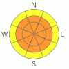
Danger Rose Tutorial
|
The overall danger is level 3 or Considerable in the backcountry around Logan, and dangerous avalanche conditions exist on drifted slopes and in exposed terrain. Avoid steep slopes with significant recent deposits of drifted snow where you are likely to trigger wind slab and perhaps more dangerous hard slab avalanches. Avoid cornices along the ridge lines, which could break further back than expected. Careful snowpack evaluation, cautious route finding, and conservative decision making are essential today. |
|
|
CURRENT CONDITIONS |

|
The Tony Grove Snotel at 8400' reports 7 degrees and 6 inches of new snow containing 6/10ths of an inch of water in the last 24 hours. I'm reading 96 inches of total snow on the ground, containing 144% of normal water content for the date. We found nice shallow powder riding conditions in sheltered terrain and a variety of scoured crusts and wind damaged or drifted snow in exposed terrain yesterday. All this will be obscured by a few inches of fresh snow from overnight. |
|
|
RECENT ACTIVITY |

|
We received several reports of people unintentionally triggering and of a few caught and carried by wind slab avalanches in the Central Wasatch Range in the last few days. Some injuries have also been mentioned, and we've posted information about Saturday's Mt. Aire accident ...
Locally: yesterday afternoon, we remote triggered a fairly large hard slab avalanche from around 40 feet away on our way down the lower Steam Mill/White Pine ridge. The avalanche included a fair amount of freshly drifted snow but it also stepped down into old snow well below the thick and solid MLK rain-crust, running on the surface hoar/ facet layer that was buried and preserved a month ago on 1/8..
Check our backcountry avalanche list.... HERE |
|
|
THREAT #1 |

|
| WHERE |
PROBABILITY |
SIZE |
TREND |
|
|
|
|
| |
|
|
Over the next
24 hours.
|
|
|
You're likely to encounter significant recently formed wind slabs around two feet deep in exposed terrain today. Strong west winds yesterday swung around from the north overnight and may develop a bit of an easterly component today as the low pressure system pushes off to the southeast... You could find dangerous wind slabs on slopes facing almost any direction, but lee east and southeast facing slopes picked up substantial wind loads and deep stiff drifts yesterday. Last night's snow may have hidden obvious drifts under a bit of powder. Watch for and avoid wind drifts on steep slopes off the lee sides of ridges and sub-ridges and in the trees. Be wary of other places where the sustained winds could deposit the snow, like under cliff bands, around rock outcroppings, along gully walls, or in scoops or depressions. Wind slabs will form downwind of open flats, at the bottom of open slopes and on the peripheries of large meadows where the wind can pick up and carry snow. Remember that continued significant wind drifting and cracking are red flags indicating the potential for wind slab type activity. |
|
|
THREAT #2 |

|
| WHERE |
PROBABILITY |
SIZE |
TREND |
|
|
|
|
| |
|
|
Over the next
24
hours.
|
|
|
The new significant load on drifted slopes may activated or reactivate buried persistent weak layers consisting of surface hoar or sugary faceted snow. The avalanche we remote triggered yesterday is proof of the pudding, and the serpent is still lurking in places. Dangerous and destructive hard slab avalanches involving old snow and in the 2 to 4+ foot-deep range are quite possible on slopes with significant recent loading. There may be no warning signs, but collapsing is a major red flag. You might trigger this type of avalanche remotely or from a distance, hopefully not from below.... |
|
|
THREAT #3 |

|
| WHERE |
PROBABILITY |
SIZE |
TREND |

|
|
|
|
| |
|
|
Over the next
24
hours.
|
|
|
Cornices could break further back and be larger than expected. Not a good time to be messing around with the big ones.... |
|
|
MOUNTAIN WEATHER |

|
The system is departing the region leaving us in a cold north flow. We could see a few more snowflakes late tomorrow as the final trailing cold front brushes by the region... We'll be under the stagnate influence of a high pressure system in the later part of the week with gradually warming fair weather in the mountains and building inversions in the valleys a good bet. |
|
|
GENERAL ANNOUNCEMENTS |
You can view a photo summary of last year's avalanche activity in the Logan Area HERE
Join the friends of the Utah Avalanche Center in Logan on facebook. Click HERE
I will update this advisory in the mornings on Mondays, Wednesdays, Fridays, and Saturdays, and on other days if backcountry avalanche conditions warrant...
You have the opportunity to participate in the creation of our own community avalanche advisory by submitting avalanche and snow observations. You can also call us at 801-524-5304 or Toby at 435-757-7578, or email by clicking HERE
Donate to your favorite non-profit – The Friends of the Utah Avalanche Center. The UAC depends on contributions from users like you to support our work.
This advisory is from the U.S.D.A. Forest Service, which is solely responsible for its content. This advisory describes general avalanche conditions and local variations always occur. |
|
|
This information does not apply to developed ski areas or highways where avalanche control is normally done. This advisory is from the U.S.D.A. Forest Service, which is solely responsible for its content. This advisory describes general avalanche conditions and local variations always occur. |
|
This advisory provided by the USDA Forest Service, in partnership with:
The Friends of the Utah Avalanche Center, Utah Division of State Parks and Recreation, Utah Division of Emergency Management, Salt Lake County, Salt Lake Unified Fire Authority and the friends of the La Sal Avalanche Center. See our Sponsors Page for a complete list. |
