BOTTOM LINE
Danger by aspect and elevation on slopes approaching 35° or steeper.
(click HERE for tomorrow's danger rating)
|
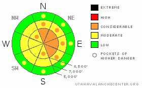
Danger Rose Tutorial
|
The danger will rise throughout today, becoming level 3 or Considerable by this afternoon in some drifted upper elevation terrain... Currently, there's a level 2 danger, heightened avalanche conditions exist in exposed terrain, and you could trigger wind slab avalanches on steep slopes with significant recent deposits of freshly drifted snow. Avoid building cornices along the ridge lines, which could break further back and be larger than expected. Accumulating significant snowfall could cause potential for triggered storm snow avalanches on steep slopes even in more sheltered terrain. Careful snowpack evaluation, cautious route finding, and conservative decision making will become essential today. |
|
|
CURRENT CONDITIONS |

|
You'll find a variety of dust-on-crust conditions in the backcountry today, with sheltered lower angled upper and mid elevation slopes offering the best dense shallow powder riding conditions. The Highway 89 Logan Summit weather station reports a balmy 29 degrees and intensifying northwest winds this morning, currently putting down average wind speed in the mid thirties and gusting to nearly 50 mph. The Tony Grove Snotel at 8400' reports 25 degrees and a couple inches of new snow containing 4/10ths of an inch of water in the last 24 hours and 8/10ths in the last 48. I'm reading 90 inches of total snow on the ground, containing 143% of normal water content for the date. |
|
|
RECENT ACTIVITY |

|
We received several reports of people unintentionally triggering and of a few caught and carried by wind slab avalanches in the Central Wasatch Range in the last few days. Some injuries have also been mentioned ... Locally, an observer noted evidence of recent avalanches in the Cornice Ridge Area, with a large debris pile from an avalanche probably caused by a cornice-fall.
Check our backcountry avalanche list.... HERE |
|
|
THREAT #1 |

|
| WHERE |
PROBABILITY |
SIZE |
TREND |

|
|
|
|
| |
|
|
Over the next
24 hours.
|
|
|
You're likely to encounter more recent and building wind slabs in exposed terrain today. Strong west winds picked up steam again this morning, and with more snow falling already today, fresh wind slabs will build up fairly rapidly. Watch for and avoid wind drifts on steep slopes off the lee sides of ridges and sub-ridges and in the trees. Be wary of other places where the sustained winds could deposit the snow, like under cliff bands, around rock outcroppings, along gully walls, or in scoops or depressions. Wind slabs will form downwind of open flats, at the bottom of open slopes and on the peripheries of large meadows where the wind can pick up and carry snow. Remember that continued significant wind drifting and cracking are red flags indicating the potential for wind slab type activity. |
|
|
THREAT #2 |

|
| WHERE |
PROBABILITY |
SIZE |
TREND |
|
|
|
|
| |
|
|
Over the next
24
hours.
|
|
|
Cornices could break further back and be larger than expected. Not a good time to be messing around with the big ones.... |
|
|
THREAT #3 |

|
| WHERE |
PROBABILITY |
SIZE |
TREND |

|
|
|
|
| |
|
|
Over the next
24
hours.
|
|
|
With 5 to 9 inches of accumulation forecast, significant snowfall on existing shallowly buried persistent weak layers could cause the potential for triggered storm snow and/or persistent slab avalanches on some steep slopes. More than expected snow will cause a higher and more widespread danger. |
|
|
MOUNTAIN WEATHER |

|
The National weather service has issued a Winter Weather Advisory for our region today. 5 to 9 inches of snow are forecast to accumulate and strong and gusty west winds will cause considerable drifting... Snow and winds should tapper off later tonight after peaking this evening. A ridge of high pressure will build over the region later in the week... |
|
|
GENERAL ANNOUNCEMENTS |
You can view a photo summary of last year's avalanche activity in the Logan Area HERE
Join the friends of the Utah Avalanche Center in Logan on facebook. Click HERE
I will update this advisory in the mornings on Mondays, Wednesdays, Fridays, and Saturdays, and on other days if backcountry avalanche conditions warrant...
You have the opportunity to participate in the creation of our own community avalanche advisory by submitting avalanche and snow observations. You can also call us at 801-524-5304 or Toby at 435-757-7578, or email by clicking HERE
Donate to your favorite non-profit – The Friends of the Utah Avalanche Center. The UAC depends on contributions from users like you to support our work.
This advisory is from the U.S.D.A. Forest Service, which is solely responsible for its content. This advisory describes general avalanche conditions and local variations always occur. |
|
|
This information does not apply to developed ski areas or highways where avalanche control is normally done. This advisory is from the U.S.D.A. Forest Service, which is solely responsible for its content. This advisory describes general avalanche conditions and local variations always occur. |
|
This advisory provided by the USDA Forest Service, in partnership with:
The Friends of the Utah Avalanche Center, Utah Division of State Parks and Recreation, Utah Division of Emergency Management, Salt Lake County, Salt Lake Unified Fire Authority and the friends of the La Sal Avalanche Center. See our Sponsors Page for a complete list. |
