BOTTOM LINE
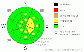
Danger by aspect and elevation on slopes approaching 35° or steeper.
(click HERE for tomorrow's danger rating)
|
Danger Rose Tutorial
|
There's a level 2 or Moderate danger on drifted upper elevation slopes in the backcountry. Heightened avalanche conditions exist in exposed terrain, and you could trigger wind slab avalanches on steep slopes with significant recent deposits of freshly drifted snow. You'll still probably be able to find fairly stable snow and a level 1 danger in sheltered terrain and in most lower elevation areas. Evaluate the snow and terrain carefully, especially on upper elevation drifted slopes.
Expect the overall danger to continue its gradual rise over the weekend, with an assortment of weak layers still near today's snow surface and developing snowfall and continuing winds in the forecast... |
|
|
CURRENT CONDITIONS |

|
Mountain temperatures chilled a bit overnight, and it's 25 degrees up at the Tony Grove Snotel at 8400'. The station reports a couple inches of new snow containing 4/10ths of an inch of water in the last 24 hours. I'm reading 88 inches of total snow on the ground, containing 142% of normal water content for the date. The Campbell Scientific Logan Peak weather station at 9700' reports a 18 degrees this morning and the wind sensor appears rimed again. The Logan Summit station reports intensifying and sustained northwest and west-northwest winds averaging in the upper thirties and gusting a bit over 50 mph this morning. You'll find variable snow conditions in the backcountry today, with a few soft and shallow recrystallized stashes left in sheltered shady mid elevation terrain... Sun-crusts and wind-jacked snow are widespread, and I've received reports of solid and glistening "blue" ice on the big east faces in the Wellsville Mountain Wilderness, where you will need crampons and axes if you want to venture. |
|
|
RECENT ACTIVITY |

|
We received reports of two people caught and carried by separate wind slab avalanches in the Central Wasatch Range Thursday... No recent avalanches have been reported in the Logan Area
Check our backcountry avalanche list.... HERE |
|
|
THREAT #1 |

|
| WHERE |
PROBABILITY |
SIZE |
TREND |

|
|
|
|
| |
|
|
Over the next
24 hours.
|
|
|
You're likely to encounter fresh and building wind slabs in exposed terrain today. Strong west and northwest winds overnight didn't have a whole lot of fresh new snow to drift around, but I suspect there was enough to form fresh wind slabs up to around a foot deep in places. Northwest winds will continue to be fairly strong this morning and a bit more snowfall is possible. Watch for and avoid stiff and freshly formed wind drifts on steep slopes off the lee sides of ridges and sub-ridges and in the trees. Be wary of other places where the sustained winds might have deposited the snow, like under cliff bands, around rock outcroppings, along gully walls, or in scoops or depressions. Wind slabs will form downwind of open flats and large meadows where the wind can pick up and carry snow. Remember that continued significant wind drifting and cracking are red flags indicating the potential for wind slab type activity. |
|
|
MOUNTAIN WEATHER |

|
The first in a series of waves of storminess is passing through the zone this morning, with strong northwest winds and and a few inches of graupel and rimed snow reported. We'll see a bit more snow and continuing west and northwest winds, tapering off this afternoon. Another weak wave will affect the zone tomorrow, and a more significant and productive shot of storminess is set for Monday evening, with the passage of the cold front... |
|
|
GENERAL ANNOUNCEMENTS |
You can view a photo summary of last year's avalanche activity in the Logan Area HERE
Join the friends of the Utah Avalanche Center in Logan on facebook. Click HERE
I will update this advisory in the mornings on Mondays, Wednesdays, Fridays, and Saturdays, and on other days if backcountry avalanche conditions warrant...
You have the opportunity to participate in the creation of our own community avalanche advisory by submitting avalanche and snow observations. You can also call us at 801-524-5304 or Toby at 435-757-7578, or email by clicking HERE
Donate to your favorite non-profit – The Friends of the Utah Avalanche Center. The UAC depends on contributions from users like you to support our work.
This advisory is from the U.S.D.A. Forest Service, which is solely responsible for its content. This advisory describes general avalanche conditions and local variations always occur. |
|
|
This information does not apply to developed ski areas or highways where avalanche control is normally done. This advisory is from the U.S.D.A. Forest Service, which is solely responsible for its content. This advisory describes general avalanche conditions and local variations always occur. |
|
This advisory provided by the USDA Forest Service, in partnership with:
The Friends of the Utah Avalanche Center, Utah Division of State Parks and Recreation, Utah Division of Emergency Management, Salt Lake County, Salt Lake Unified Fire Authority and the friends of the La Sal Avalanche Center. See our Sponsors Page for a complete list. |
