BOTTOM LINE
Danger by aspect and elevation on slopes approaching 35° or steeper.
(click HERE for tomorrow's danger rating)
|
Danger Rose Tutorial
|
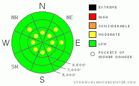
There is a Level 1 or Low danger, and avalanches are unlikely on the majority of steep slopes in the Logan Zone...However, you might still find pockets with a level 2 or Moderate danger on drifted upper elevation slopes in the backcountry. Heightened avalanche conditions may exist in some areas, and you could trigger wind slab avalanches on steep slopes with significant recent deposits of drifted snow. Evaluate the snow and terrain carefully, especially on upper elevation drifted slopes.
Expect the danger to rise over the weekend, with an assortment of weak layers near today's snow surface and developing snowfall in the forecast... |
|
|
CURRENT CONDITIONS |

|
You'll find variable snow conditions in the backcountry today, with a few soft and shallow recrystallized stashes left in sheltered shady terrain... Sun-crusts and wind-jacked snow are widespread, and I've received reports of solid and glistening "blue" ice on the big east faces in the Wellsville Mountain Wilderness, where you will need crampons and axes if you want to venture. Mountain temperatures climbed overnight, and it's 30 degrees up at the Tony Grove Snotel at 8400'. The station reports 88 inches of total snow on the ground, containing 142% of normal water content for the date. The Campbell Scientific Logan Peak weather station at 9700' reports a balmy 19 degrees this morning and continuing sustained north-northwest winds averaging in the mid twenties. |
|
|
RECENT ACTIVITY |

|
We received reports of two people caught and carried by separate wind slab avalanches in the Central Wasatch Range yesterday... No recent avalanches have been reported in the Logan Area
Check our backcountry avalanche list.... HERE |
|
|
THREAT #1 |

|
| WHERE |
PROBABILITY |
SIZE |
TREND |

|
|
|
|
| |
|
|
Over the next
24 hours.
|
|
|
After Tuesday's somewhat uncommon easterly wind event, winds shifted back around from the north and remained stiff and sustained. It's a good thing we didn't have much fresh snow to drift around, and I've only been able to find small drifts, scoured areas, and thin wind crusts. You could find recently built wind slabs in some areas. These will mostly be fairly shallow, but some could be stiff and wide enough to pose a threat.. Expect to find drifts in somewhat uncommon locations. They are easy to identify if you know what to look for; smooth or rounded areas, chalky looking, small grained or stiff snow, hollow sounding. Remember that cracking is a red flag for this type of activity. Watch for and avoid fresh wind drifts on steep slopes off the lee sides of ridges and sub-ridges and in the trees. Be wary of other places where the cold and sustained winds might have deposited the snow, like under cliff bands, around rock outcroppings, along gully walls, or in scoops or depressions. |
|
|
MOUNTAIN WEATHER |

|
Clouds are rolling in this morning, and snow is in the forecast for the weekend and into next week. Most of the storm energy will pass to our north and east today, but we may see an inch or two of accumulation tonight and again tomorrow. It looks like more significant snowfall will begin late Sunday, lasting through Monday, with moisture lingering into mid-week. The gradual onset of snowfall should not lull us into complacency, and given the current snow conditions, expect the avalanche danger to increase significantly and perhaps rapidly as we head into next week.... |
|
|
GENERAL ANNOUNCEMENTS |
You can view a photo summary of last year's avalanche activity in the Logan Area HERE
Join the friends of the Utah Avalanche Center in Logan on facebook. Click HERE
I will update this advisory in the mornings on Mondays, Wednesdays, Fridays, and Saturdays, and on other days if backcountry avalanche conditions warrant...
You have the opportunity to participate in the creation of our own community avalanche advisory by submitting avalanche and snow observations. You can also call us at 801-524-5304 or Toby at 435-757-7578, or email by clicking HERE
Donate to your favorite non-profit – The Friends of the Utah Avalanche Center. The UAC depends on contributions from users like you to support our work.
This advisory is from the U.S.D.A. Forest Service, which is solely responsible for its content. This advisory describes general avalanche conditions and local variations always occur. |
|
|
This information does not apply to developed ski areas or highways where avalanche control is normally done. This advisory is from the U.S.D.A. Forest Service, which is solely responsible for its content. This advisory describes general avalanche conditions and local variations always occur. |
|
This advisory provided by the USDA Forest Service, in partnership with:
The Friends of the Utah Avalanche Center, Utah Division of State Parks and Recreation, Utah Division of Emergency Management, Salt Lake County, Salt Lake Unified Fire Authority and the friends of the La Sal Avalanche Center. See our Sponsors Page for a complete list. |
