BOTTOM LINE
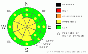
Danger by aspect and elevation on slopes approaching 35° or steeper.
(click HERE for tomorrow's danger rating)
|
Danger Rose Tutorial
|
There is a level 2 or Moderate danger on drifted slopes in the backcountry. Heightened avalanche conditions exist, and you could trigger wind slab avalanches on steep slopes with fresh deposits of drifted snow. Somewhat uncommon northeast winds probably drifted newly fallen snow onto steep slopes in unexpected as well as obvious areas. Evaluate the snow and terrain carefully, especially on wind drifted slopes. |
|
|
CURRENT CONDITIONS |

|
Severely bitter cold and off-the-chart wind-chills kept me out of the mountains yesterday, but observers report drifting snow and slow going in the backcountry. Temperatures climbed above zero this morning, and it's 2 degrees up at the Tony Grove Snotel at 8400'. The station reports a few inches of new snow from Monday and Monday night, and with 92 inches of total snow on the ground, the station claims 145% of normal water content for the date. There is much less snow at lower elevations and in other parts of the zone, and the shallow snow is weak and sugary or faceted in some areas . After functioning in nearly 50 degree below zero wind-chill temperatures yesterday, the Campbell Scientific Logan Peak weather station at 9400' reports a negative 34 degree wind-chill this morning and 10 degrees below zero, with a sustained north wind averaging in the twenties. |
|
|
RECENT ACTIVITY |

|
We received reports of several small and manageable triggered wind slabs in the Central Wasatch Range yesterday... No recent avalanches have been reported in the Logan Area
Check our backcountry avalanche list.... HERE |
|
|
THREAT #1 |

|
| WHERE |
PROBABILITY |
SIZE |
TREND |

|
|
|
|
| |
|
|
Over the next
24 hours.
|
|
|
After yesterday's chilly and somewhat uncommon easterly wind, you will find freshly built wind slabs in many areas. These will mostly be fairly shallow, but could be stiff and wide enough to pose a threat.. Expect to find drifts in somewhat uncommon locations. Watch for and avoid fresh wind drifts on the lee sides of ridges and sub-ridges and in the trees. Be wary of other places where yesterday's winds might have deposited the snow, like under cliff bands, around rock outcroppings, along gully walls, or in scoops or depressions. |
|
|
MOUNTAIN WEATHER |

|
Expect another cold but sunny day in the mountains, with a cold northwest wind and upper elevation temperatures likely to remain sub-zero. We'll see a gradual increase in temperatures, with highs around 20 degrees tomorrow and a few clouds. The weekend will bring a chance for a bit of snow as a series of shortwave troughs drive through the region, but models are in a bit of disagreement about the timing and strength of these... There is a chance of snow beginning late Friday and more possibilities through the weekend. |
|
|
GENERAL ANNOUNCEMENTS |
You can view a photo summary of last year's avalanche activity in the Logan Area HERE
Join the friends of the Utah Avalanche Center in Logan on facebook. Click HERE
I will update this advisory in the mornings on Mondays, Wednesdays, Fridays, and Saturdays, and on other days if backcountry avalanche conditions warrant...
You have the opportunity to participate in the creation of our own community avalanche advisory by submitting avalanche and snow observations. You can also call us at 801-524-5304 or Toby at 435-757-7578, or email by clicking HERE
Donate to your favorite non-profit – The Friends of the Utah Avalanche Center. The UAC depends on contributions from users like you to support our work.
This advisory is from the U.S.D.A. Forest Service, which is solely responsible for its content. This advisory describes general avalanche conditions and local variations always occur. |
|
|
This information does not apply to developed ski areas or highways where avalanche control is normally done. This advisory is from the U.S.D.A. Forest Service, which is solely responsible for its content. This advisory describes general avalanche conditions and local variations always occur. |
|
This advisory provided by the USDA Forest Service, in partnership with:
The Friends of the Utah Avalanche Center, Utah Division of State Parks and Recreation, Utah Division of Emergency Management, Salt Lake County, Salt Lake Unified Fire Authority and the friends of the La Sal Avalanche Center. See our Sponsors Page for a complete list. |
