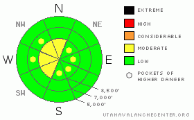
BOTTOM LINE
Danger by aspect and elevation on slopes approaching 35° or steeper.
(click HERE for tomorrow's danger rating)
|
Danger Rose Tutorial
|
There is a level 2 or Moderate danger on drifted upper elevation slopes in the backcountry. You could trigger fresh wind slab avalanches up to around a foot deep on steep slopes with fresh deposits of drifted snow. Dangerous persistent slab avalanches are unlikely and would probably be difficult to trigger but are possible. There is a level 1 or Low danger at lower elevations and in sheltered terrain, and stable snow conditions can be found on the majority of steep slopes in the zone. Use normal caution, continue to follow safe travel protocols, and evaluate the snow and terrain carefully, especially on wind exposed upper elevation slopes. |
|
|
CURRENT CONDITIONS |

|
Most of the popular areas are well ridden and pretty well tracked up after a very busy weekend in the mountains, but you can still find shallow recrystallized powder stashes in places. Sunny slopes are crusty and conditions are pretty variable in upper elevation wind exposed terrain. I spun my track down through the deteriorated mid January crust a couple times this weekend, and I had to pull out the shovels and dig out of a few feet of rather sugary or faceted snow.... Temperatures cooled down overnight and it's 19 degrees up at the Tony Grove Snotel at 8400'. The station reports an angry inch of new snow, and with 89 inches of total snow on the ground, we're looking at 147% of normal water content for the date, but there is much less snow at lower elevations and in other parts of the zone. The Campbell Scientific Logan Peak weather station at 9400' reports 10 degrees and northwest winds averaging in the mid-teens overnight. |
|
|
RECENT ACTIVITY |

|
A skier triggered and was able to ride off a small wind slab in the Central Wasatch Range yesterday... No recent avalanches have been reported in the Logan Area, even after a busy weekend in the backcountry.
Check our backcountry avalanche list.... HERE |
|
|
THREAT #1 |

|
| WHERE |
PROBABILITY |
SIZE |
TREND |

|
|
|
|
| |
|
|
Over the next
24 hours.
|
|
|
You could find some shallow and building fresh wind slabs in exposed terrain. Fresh snow will be drifted onto surface hoar or other weak surface snow in some places, and gradually increasing northwest winds, switching around from the north and east tomorrow will cause a rising danger. Given a forecast for somewhat uncommon easterly winds tomorrow, we'll have to expect drifts in somewhat uncommon locations. Watch for and avoid fresh wind drifts on the lee sides of ridges and sub-ridges and in other places where winds drop snow, like under cliff bands, around rock outcroppings, along gully walls, or in scoops or depressions. |
|
|
THREAT #2 |

|
| WHERE |
PROBABILITY |
SIZE |
TREND |
|
|
|
|
| |
|
|
Over the next
12 hours.
|
|
|
Although unlikely and possible only in isolated locations, persistent hard slab avalanches breaking on buried weak layers below the crust and 2 to 3 feet deep could be unmanageable, destructive, and dangerous. They might be triggered remotely and involve snow on lower angled slopes than you might expect. Pay attention to red flags like cracking, or collapsing. |
|
|
MOUNTAIN WEATHER |

|
We'll see snow showers, colder temperatures and gradually increasing northwest winds today, with a few inches of accumulation possible... An inch or two of snow is likely tonight, with temperatures dropping below zero. Expect arctic temperatures tomorrow and north winds shifting around and coming from an easterly direction. A high pressure system will control the weather pattern through most of the upcoming week and with cold arctic air on the way valley inversions will likely be strong, brown, and unhealthy. |
|
|
GENERAL ANNOUNCEMENTS |
You can view a photo summary of last year's avalanche activity in the Logan Area HERE
Join the friends of the Utah Avalanche Center in Logan on facebook. Click HERE
I will update this advisory in the mornings on Mondays, Wednesdays, Fridays, and Saturdays, and on other days if backcountry avalanche conditions warrant...
You have the opportunity to participate in the creation of our own community avalanche advisory by submitting avalanche and snow observations. You can also call us at 801-524-5304 or Toby at 435-757-7578, or email by clicking HERE
Donate to your favorite non-profit – The Friends of the Utah Avalanche Center. The UAC depends on contributions from users like you to support our work.
This advisory is from the U.S.D.A. Forest Service, which is solely responsible for its content. This advisory describes general avalanche conditions and local variations always occur. |
|
|
This information does not apply to developed ski areas or highways where avalanche control is normally done. This advisory is from the U.S.D.A. Forest Service, which is solely responsible for its content. This advisory describes general avalanche conditions and local variations always occur. |
|
This advisory provided by the USDA Forest Service, in partnership with:
The Friends of the Utah Avalanche Center, Utah Division of State Parks and Recreation, Utah Division of Emergency Management, Salt Lake County, Salt Lake Unified Fire Authority and the friends of the La Sal Avalanche Center. See our Sponsors Page for a complete list. |
