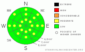
BOTTOM LINE
Danger by aspect and elevation on slopes approaching 35° or steeper.
(click HERE for tomorrow's danger rating)
|
Danger Rose Tutorial
|
There are many pockets with a level 2 or Moderate danger in the backcountry around Logan. Lingering buried persistent weak layers, sustained winds, and warming mountain temperatures all indicate heightened avalanche conditions, and triggered avalanches are possible on some steep slopes this weekend. At the same time, there is a level 1 or Low danger and stable snow conditions can be found on the majority of steep slopes in the zone. Although unlikely and in isolated locations, persistent hard slab avalanches could be unmanageable, destructive, and dangerous. They could be triggered remotely and involve snow on lower angled slopes than you might expect. Wind slab and cornice fall type avalanches are possible in drifted upper elevation terrain. Solar warming and green-housing could cause an increasing danger of wet avalanches on slopes with soft and saturated surface snow. Use normal caution, continue to follow safe travel protocols, and evaluate the snow and terrain carefully. |
|
|
CURRENT CONDITIONS |

|
You can find nice shallow powder riding conditions on a supportable base, especially nice in sheltered and shady terrain.. Sunny slopes are alternating between being soft and mushy to variable and crusty.
Temperatures cooled a bit overnight and it's 26 degrees up at the Tony Grove Snotel at 8400', and with 90 inches of total snow on the ground, the snow at the station contains just a little less than150% of normal water content for the date.... The rime on the wind sensor at the Campbell Scientific Logan Peak weather station melted off yesterday as forecast, and is now reading westerly winds averaging in the teens. The winds appear to be subsiding a bit overnight since yesterday evening mid-twenties averages from the southwest. |
|
|
RECENT ACTIVITY |

|
Yesterday, while investigating recent activity a couple avalanche professionals from the UAC and UDOT remote triggered another good sized hard slab avalanche releasing on buried surface hoar under the solid rime-crust in the Provo Area Mountains. Snow Safety teams at a Wasatch Ski Area report triggering similar dangerous avalanches with explosives this week, and riders triggered a handful of similar slides in the Western Uinta range over the past several days. No significant avalanches have been reported from the Logan Area since the widespread natural cycle over the MLK-weekend, in which the avalanches failed on weak layer formed and buried at the same time, (around 1/8)....
Check our backcountry avalanche list.... HERE |
|
|
THREAT #1 |

|
| WHERE |
PROBABILITY |
SIZE |
TREND |
|
|
|
|
| |
|
|
Over the next
24 hours.
|
|
|
Triggered persistent slabs breaking on buried weak layers below the crust and 2 to 3 feet deep are rather unlikely but still possible today. The 1-16 rime-crust is gradually degrading, and solar warming could change slab properties on some slopes. Pay attention to red flags like rapid warming, cracking, or collapsing.
Also, watch for and avoid stiff wind slabs on the lee sides of ridges and sub-ridges and in terrain dictated deposition areas, like under cliff bands, around rock outcroppings, along gully walls, or in scoops or depressions..... You could trigger wind slabs, around 1 foot-deep, on isolated steep drifted slopes... |
|
|
THREAT #2 |

|
| WHERE |
PROBABILITY |
SIZE |
TREND |
|
|
|
|
| |
|
|
Over the next
12 hours.
|
|
|
Recently enlarged, and in some cases huge, ridge-top cornices could break further back than expected. Warming this weekend will cause some of these monsters to sag, and some could naturally calve off in large chunks. |
|
|
THREAT #3 |

|
| WHERE |
PROBABILITY |
SIZE |
TREND |
|
|
|
|
| |
|
|
Over the next
10 hours.
|
|
|
Increasing cloud cover today should keep a lid on the heating, but morning warmth could also be trapped in the atmosphere like in a green-house. If things warm up again, loose wet avalanches are possible today on any steep slope with soft and saturated surface snow. Be extra cautious on steep slopes above gullies, trees, or other terrain traps... |
|
|
MOUNTAIN WEATHER |

|
Expect increasing clouds today, with mountain temperatures rising a few degrees above freezing and fairly light southwest winds. Snow will develop by tomorrow afternoon and we could pick up a few inches of snow, with 4 to 8 inches of accumulation forecast to fall in the mountains by Monday night. Intensifying northwest winds on Monday and a bit of fresh and falling snow to drift around will probably cause an increase in the avalanche danger... |
|
|
GENERAL ANNOUNCEMENTS |
Come to the TSC Ballroom at USU at 7:00 on Monday January 31,and support local filmmaker Jeremy Jensen at the first showing of "Powder Day Saints, the Second Coming", a locally produced snowboard, ski, powdersurfing film featuring local riders..
You can view a photo summary of last year's avalanche activity in the Logan Area HERE
Join the friends of the Utah Avalanche Center in Logan on facebook. Click HERE
I will update this advisory in the mornings on Mondays, Wednesdays, Fridays, and Saturdays, and on other days if backcountry avalanche conditions warrant...
You have the opportunity to participate in the creation of our own community avalanche advisory by submitting avalanche and snow observations. You can also call us at 801-524-5304 or Toby at 435-757-7578, or email by clicking HERE
Donate to your favorite non-profit – The Friends of the Utah Avalanche Center. The UAC depends on contributions from users like you to support our work.
This advisory is from the U.S.D.A. Forest Service, which is solely responsible for its content. This advisory describes general avalanche conditions and local variations always occur. |
|
|
This information does not apply to developed ski areas or highways where avalanche control is normally done. This advisory is from the U.S.D.A. Forest Service, which is solely responsible for its content. This advisory describes general avalanche conditions and local variations always occur. |
|
This advisory provided by the USDA Forest Service, in partnership with:
The Friends of the Utah Avalanche Center, Utah Division of State Parks and Recreation, Utah Division of Emergency Management, Salt Lake County, Salt Lake Unified Fire Authority and the friends of the La Sal Avalanche Center. See our Sponsors Page for a complete list. |
