BOTTOM LINE
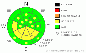
Danger by aspect and elevation on slopes approaching 35° or steeper.
(click HERE for tomorrow's danger rating)
|
Danger Rose Tutorial
|
We'll call it Level 2 or Moderate. We’re faced by the classic low probability with high consequence conundrum. The avalanche danger is level 1 or Low on most slopes in the region, meaning that avalanches are fairly unlikely, but possible. The problem is that any possible triggered persistent hard slab avalanches could be unmanageable and dangerous (more like pockets of level 3,) and it’s growing more difficult to isolate the problem to specific slopes. Heightened avalanche conditions exist, and solar warming may cause an increasing danger on some slopes. Use normal caution, continue to follow safe travel protocols, and evaluate the snow and terrain carefully, especially sunny and generally shallow areas. |
|
|
CURRENT CONDITIONS |

|
We've been able to find some nice shallow powder conditions with a solid, supportable base. You still feel the solid crust from the MLK-Day weekend (1-16) on steep slopes and at lower elevations. Unless you're carrying your ice axe and crampons, you'll probably want to avoid some of the steep windward slopes that are scoured down to a hard and slippery ice-crust and present slide-for-life hazards, not to mention difficult riding. The Tony Grove Snotel at 8400' reported 3 inches of new snow yesterday, with 3/10ths of an inch of water. It's 16 degrees, and with 94 inches of total snow on the ground, the snow at the station contains 155% of normal water content for the date.... The wind sensor at the Campbell Scientific Logan Peak weather station is thickly coated by rime and ice, like all the trees at upper elevations. Mt. Ogden reports light to moderate west ridgetop winds. |
|
|
RECENT ACTIVITY |

|
We received reports of a handful of unintentional triggered persistent slab avalanches across the mountains of northern Utah in the past several days, with dangerous hard slabs releasing on buried surface hoar under the solid rime-crust. No significant avalanches have been reported from the Logan Area since the widespread natural cycle over the MLK-weekend .... Check our backcountry avalanche list.... HERE
I triggered two heart stopping audible collapses yesterday on a sunny mid-elevation slope, and as shallow slopes are warmed by the sun and the widespread crust continues to gradually degrade, dangerous triggered hard slabs remain possible.. |
|
|
THREAT #1 |

|
| WHERE |
PROBABILITY |
SIZE |
TREND |

|
|
|
|
| |
|
|
Over the next
24 hours.
|
|
|
Triggered persistent slabs breaking on buried weak layers below the crust and 1 to 3 feet deep are rather unlikely but still possible today. The 1-16 rime-crust is gradually degrading, and solar warming could change slab properties on some slopes. Pay attention to red flags like rapid warming, cracking, or collapsing. |
|
|
THREAT #2 |

|
| WHERE |
PROBABILITY |
SIZE |
TREND |

|
|
|
|
| |
|
|
Over the next
12 hours.
|
|
|
Recently enlarged and in some cases huge ridge-top cornices could break further back than expected.
Also, watch for and avoid stiff wind slabs on the lee sides of ridges and sub-ridges and in terrain dictated deposition areas, like under cliff bands, around rock outcroppings, along gully walls, or in scoops or depressions..... You could trigger 1-2 foot-deep wind slabs running on or above last weekend's ice-crust on steep drifted slopes. |
|
|
MOUNTAIN WEATHER |

|
We're headed into a high pressure system, and I expect building haze in the valley, with fair and warmer weather in the mountains. The high pressure will strengthen in the next several days and last through the weekend.... |
|
|
GENERAL ANNOUNCEMENTS |
You can still sign up for our level 2 class with the USU Outdoor Recreation Program... The class is next weekend, starting on Thursday evening, January 27. Click HERE for more details...
You can view a photo summary of last year's avalanche activity in the Logan Area HERE
Join the friends of the Utah Avalanche Center in Logan on facebook. Click HERE
I will update this advisory in the mornings on Mondays, Wednesdays, Fridays, and Saturdays, and on other days if backcountry avalanche conditions warrant...
You have the opportunity to participate in the creation of our own community avalanche advisory by submitting avalanche and snow observations. You can also call us at 801-524-5304 or Toby at 435-757-7578, or email by clicking HERE
Donate to your favorite non-profit – The Friends of the Utah Avalanche Center. The UAC depends on contributions from users like you to support our work.
This advisory is from the U.S.D.A. Forest Service, which is solely responsible for its content. This advisory describes general avalanche conditions and local variations always occur. |
|
|
This information does not apply to developed ski areas or highways where avalanche control is normally done. This advisory is from the U.S.D.A. Forest Service, which is solely responsible for its content. This advisory describes general avalanche conditions and local variations always occur. |
|
This advisory provided by the USDA Forest Service, in partnership with:
The Friends of the Utah Avalanche Center, Utah Division of State Parks and Recreation, Utah Division of Emergency Management, Salt Lake County, Salt Lake Unified Fire Authority and the friends of the La Sal Avalanche Center. See our Sponsors Page for a complete list. |
