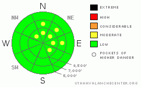
BOTTOM LINE
Danger by aspect and elevation on slopes approaching 35° or steeper.
(click HERE for tomorrow's danger rating)
|
Danger Rose Tutorial
|
The danger is Level 1 or Low on most slopes in the Logan Zone, but there are pockets with a level 2 or Moderate danger in drifted upper elevation terrain. Heightened avalanche conditions exist, and you could trigger 1 to 2 foot deep wind slab avalanches on slopes steeper than about 35 degrees with significant deposits of drifted fresh snow. Although unlikely, there is still a chance you might trigger an isolated dangerous hard or persistent slab avalanche on very steep slopes at upper elevations.... Use normal caution, continue to follow safe travel protocols, and evaluate the snow and terrain carefully, especially in high wind exposed areas. |
|
|
CURRENT CONDITIONS |

|
The Central Bear River Range picked up more snow in the last week, and you'll be able to find nice shallow powder conditions and a solid, supportable base.... It's still more like dust-on-crust down low and on many slopes in the Southern Bear River and Wellsville Ranges. Windward slopes and those with only shallow fresh snow sport a hard and slippery ice-crust and slide-for-life hazards. In fact there are many steep slopes that I wouldn't even attempt to climb now without an ice axe and crampons... The Tony Grove Snotel at 8400' reported 7 inches of new snow from Friday night and Saturday, with a storm total of 1.3 inches of water. It's 17 degrees, and with 94 inches of total snow on the ground, the snow at the station contains 157% of normal water content for the date.... |
|
|
RECENT ACTIVITY |

|
We received reports of a handful of triggered wind slab avalanches over the weekend across the mountains of northern Utah, with explosives pulling out a few isolated hard slabs running on persistent layers in the Wasatch yesterday. No significant avalanches have been reported from the Logan Area since the MLK-weekend widespread natural cycle..... Check our backcountry avalanche list.... HERE |
|
|
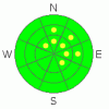
THREAT #1 |

|
| WHERE |
PROBABILITY |
SIZE |
TREND |
|
|
|
|
| |
|
|
Over the next
24 hours.
|
|
|
Watch for and avoid stiff recently formed wind slabs on the lee sides of ridges and sub-ridges and in terrain dictated deposition areas, like under cliff bands, around rock outcroppings, along gully walls, or in scoops or depressions..... You could trigger 1-2 foot-deep wind slabs running on or above last weekend's ice-crust on steep drifted slopes. Also the recently enlarged ridge-top cornices could break further back than expected. |
|
|
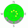
THREAT #2 |

|
| WHERE |
PROBABILITY |
SIZE |
TREND |
|
|
|
|
| |
|
|
Over the next
12 hours.
|
|
|
Isolated triggered persistent slabs breaking on buried weak layers below the crust and 1 to 3 feet deep are unlikely but still possible today at upper elevations. |
|
|
MOUNTAIN WEATHER |

|
Winds should be fairly calm this morning, with increasing clouds and mountain high temperatures in the upper twenties. A couple more weak shortwaves embedded in the persistent northwest flow will graze our area, and we'll likely see a few inches here and there before a high pressure moves in later in the week.... Snow will begin in the mountains late tonight and continue though much of tomorrow, with modest southwest winds and 2 to 5 inches of accumulation forecast. The strong high pressure system, currently based off the California coast will inch eastward, and by next weekend we'll be faced with inversions in the valleys and fair weather in the mountains.... |
|
|
GENERAL ANNOUNCEMENTS |
You can still sign up for our level 2 class with the USU Outdoor Recreation Program... The class is next weekend, starting on Thursday evening, January 27. Click HERE for more details...
You can view a photo summary of last year's avalanche activity in the Logan Area HERE
Join the friends of the Utah Avalanche Center in Logan on facebook. Click HERE
I will update this advisory in the mornings on Mondays, Wednesdays, Fridays, and Saturdays, and on other days if backcountry avalanche conditions warrant...
You have the opportunity to participate in the creation of our own community avalanche advisory by submitting avalanche and snow observations. You can also call us at 801-524-5304 or Toby at 435-757-7578, or email by clicking HERE
Donate to your favorite non-profit – The Friends of the Utah Avalanche Center. The UAC depends on contributions from users like you to support our work.
This advisory is from the U.S.D.A. Forest Service, which is solely responsible for its content. This advisory describes general avalanche conditions and local variations always occur. |
|
|
This information does not apply to developed ski areas or highways where avalanche control is normally done. This advisory is from the U.S.D.A. Forest Service, which is solely responsible for its content. This advisory describes general avalanche conditions and local variations always occur. |
|
This advisory provided by the USDA Forest Service, in partnership with:
The Friends of the Utah Avalanche Center, Utah Division of State Parks and Recreation, Utah Division of Emergency Management, Salt Lake County, Salt Lake Unified Fire Authority and the friends of the La Sal Avalanche Center. See our Sponsors Page for a complete list. |
