BOTTOM LINE
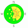
Danger by aspect and elevation on slopes approaching 35° or steeper.
(click HERE for tomorrow's danger rating)
|

Danger Rose Tutorial
|
There is a level 2 or Moderate danger in the backcountry around Logan. Heightened avalanche conditions exist, mainly at upper elevations, and triggered wind slab avalanches are possible on steep drifted slopes. Pockets with a level 3 danger also probably exist in exposed upper elevation terrain, where you would be likely to trigger wind slab avalanches if you ventured onto steep slopes. Although underlying weak layers appear locked up by a solid rime-crust, there is still a chance you might trigger an isolated hard or persistent slab avalanche at upper elevations, and these can be triggered remotely from a distance or below... Continue to practice safe travel protocols and evaluate the snow and terrain carefully, especially at upper elevations.... |
|
|
CURRENT CONDITIONS |

|
Last weekend's warm and windy storm plastered the region with a solid and supportable crust... Most areas picked up a few inches of new snow mid-week, with a bit more in the northern part of the zone and at higher elevations. Sustained northwest winds since scoured off and drifted in the fresh snow in exposed terrain... We found smooth and fast shallow powder and dust-on-crust riding conditions, with low angled slopes still best yesterday. The hard and slippery crust has created slide-for-life hazards in areas with less new snow, especially on ascent, and controlling your sled on a side-hill might be a problem at times. The Tony Grove Snotel at 8400' reports 3 inches of new snow from overnight and 1.1 inches of water in the last 24 hours, so I suspect another layer of rime..... It will be very windy today, with intensifying west and northwest winds.... |
|
|
RECENT ACTIVITY |

|
The wet, warm, and windy weather last weekend spawned an extensive natural avalanche cycle in the region, but that is old news now.... We've received reports of a handful of scary triggered avalanches in the last couple days across the mountains of northern Utah, but none have been reported from the Logan Area since last weekend's active natural cycle.....
Check our backcountry avalanche list.... HERE |
|
|
THREAT #1 |

|
| WHERE |
PROBABILITY |
SIZE |
TREND |
|
|
|
|
| |
|
|
Over the next
24 hours.
|
|
|
Watch for and avoid stiff and forming wind slabs on the lee sides of ridges and sub-ridges and in terrain dictated deposition areas, like under cliff bands, around rock outcroppings, along gully walls, or in scoops or depressions..... You could trigger 1-1.5 foot-deep wind slabs running on or above last weekend's ice-crust on steep drifted slopes. Also the recently enlarged ridge-top cornices could break further back than expected. |
|
|
THREAT #2 |

|
| WHERE |
PROBABILITY |
SIZE |
TREND |

|
|
|
|
| |
|
|
Over the next
12 hours.
|
|
|
Heightened avalanche conditions exist at upper elevations where a substantial slab rapidly built up on slopes with buried weak layers over the weekend.. Although I'm betting your weight will have little affect through the concrete-like rime crust in most areas, dangerous avalanches might be triggered on some steep slopes that did not slide during the recent ice storm. Isolated triggered persistent slabs breaking on buried weak layers below the crust and 1 to 3 feet deep are still possible today at upper elevations. Reported collapsing on upper elevation slopes in the Wasatch Range including south facing slopes warrant extra caution while traveling at upper elevations even on those often sunny slopes. |
|
|
MOUNTAIN WEATHER |

|
Expect increasing and strong west and northwest winds, dropping temperatures and clouds in the mountains today, and we could pick up a couple more inches of snow. A northwest flow aloft will continue through the weekend and well into next week. More weak shortwaves embedded in the flow will graze our area, and we'll likely see a few inches here and there before a high pressure moves in later in the week.... |
|
|
GENERAL ANNOUNCEMENTS |
You can still sign up for our level 2 class with the USU Outdoor Recreation Program... The class is next weekend, starting on Thursday evening, January 27. Click HERE for more details...
You can view a photo summary of last year's avalanche activity in the Logan Area HERE
Join the friends of the Utah Avalanche Center in Logan on facebook. Click HERE
I will update this advisory in the mornings on Mondays, Wednesdays, Fridays, and Saturdays, and on other days if backcountry avalanche conditions warrant...
You have the opportunity to participate in the creation of our own community avalanche advisory by submitting avalanche and snow observations. You can also call us at 801-524-5304 or Toby at 435-757-7578, or email by clicking HERE
Donate to your favorite non-profit – The Friends of the Utah Avalanche Center. The UAC depends on contributions from users like you to support our work.
This advisory is from the U.S.D.A. Forest Service, which is solely responsible for its content. This advisory describes general avalanche conditions and local variations always occur. |
|
|
This information does not apply to developed ski areas or highways where avalanche control is normally done. This advisory is from the U.S.D.A. Forest Service, which is solely responsible for its content. This advisory describes general avalanche conditions and local variations always occur. |
|
This advisory provided by the USDA Forest Service, in partnership with:
The Friends of the Utah Avalanche Center, Utah Division of State Parks and Recreation, Utah Division of Emergency Management, Salt Lake County, Salt Lake Unified Fire Authority and the friends of the La Sal Avalanche Center. See our Sponsors Page for a complete list. |
