BOTTOM LINE
Danger by aspect and elevation on slopes approaching 35° or steeper.
(click HERE for tomorrow's danger rating)
|
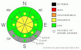
Danger Rose Tutorial
|
There is a level 2 or Moderate danger in the backcountry around Logan. Heightened avalanche conditions exist, mainly at upper elevations, and triggered wind slab or isolated hard persistent slab avalanches are possible on steep slopes. You'll find mostly stable snow conditions and a level 1 danger in sheltered and lower elevation terrain. Continue to practice safe travel protocols and evaluate the snow and terrain carefully, especially at upper elevations.... |
|
|
CURRENT CONDITIONS |

|
Last weekend's warm and windy storm plastered the region with a solid and supportable crust... Most areas picked up a few inches of new snow mid-week, with a bit more in the northern part of the zone and at higher elevations. Sustained northwest winds since scoured off and drifted in the fresh snow in exposed terrain... Observers report smooth and fast dust-on-crust riding conditions, with low angled slopes best. The hard and slippery crust has created slide-for-life fears especially on ascent, and controlling your sled could be a problem, with speed and gravity working together on steep slopes. Hard snow is rarely an issue around here this time of year so we advise caution, and lugging the crampons and ice axes might be a good idea for any serious mountain endeavors. |
|
|
RECENT ACTIVITY |

|
The wet, warm, and windy weather over the weekend spawned an extensive natural avalanche cycle in the region.... No avalanches have been reported locally since then....
See our avalanche list |
|
|
THREAT #1 |

|
| WHERE |
PROBABILITY |
SIZE |
TREND |

|
|
|
|
| |
|
|
Over the next
24 hours.
|
|
|
Watch for and avoid stiff wind slabs on the lee sides of ridges and sub-ridges and in terrain dictated deposition areas, like under cliff bands, around rock outcroppings, along gully walls, or in scoops or depressions..... Recently enlarged ridge-top cornices could break further back than expected. |
|
|
THREAT #2 |

|
| WHERE |
PROBABILITY |
SIZE |
TREND |

|
|
|
|
| |
|
|
Over the next
12 hours.
|
|
|
Heightened avalanche conditions exist at upper elevations where a substantial slab rapidly built up on slopes with buried weak layers over the weekend.. Although I'm thinking your weight will have little affect through the concrete-like rime crust, isolated triggered persistent slabs, 1 to 2 feet deep, are still possible today at upper elevations, and dangerous avalanches might be triggered on some steep slopes that did not slide during the recent ice storm. Reported collapsing on upper elevation southeast facing slopes in the Wasatch Range warrant extra caution while traveling those often sunny slopes. |
|
|
MOUNTAIN WEATHER |

|
A northwest flow aloft will continue through the weekend and into next week. A shortwave embedded in the flow will swing over the region tonight bringing a bit of snowfall. An inch or so of accumulation is expected in the valleys overnight, with a several more possible up in the mountains. Expect lingering snowfall tomorrow and fairly meager snow amounts, with most of the shortwave storm energy off to the east... At least the continuing northwest flow should keep the smoggy inversion at bay well into next week. |
|
|
GENERAL ANNOUNCEMENTS |
You can view a photo summary of last year's avalanche activity in the Logan Area HERE
Join the friends of the Utah Avalanche Center in Logan on facebook. Click HERE
I will update this advisory in the mornings on Mondays, Wednesdays, Fridays, and Saturdays, and on other days if backcountry avalanche conditions warrant...
You have the opportunity to participate in the creation of our own community avalanche advisory by submitting avalanche and snow observations. You can also call us at 801-524-5304 or Toby at 435-757-7578, or email by clicking HERE
Donate to your favorite non-profit – The Friends of the Utah Avalanche Center. The UAC depends on contributions from users like you to support our work.
This advisory is from the U.S.D.A. Forest Service, which is solely responsible for its content. This advisory describes general avalanche conditions and local variations always occur. |
|
|
This information does not apply to developed ski areas or highways where avalanche control is normally done. This advisory is from the U.S.D.A. Forest Service, which is solely responsible for its content. This advisory describes general avalanche conditions and local variations always occur. |
|
This advisory provided by the USDA Forest Service, in partnership with:
The Friends of the Utah Avalanche Center, Utah Division of State Parks and Recreation, Utah Division of Emergency Management, Salt Lake County, Salt Lake Unified Fire Authority and the friends of the La Sal Avalanche Center. See our Sponsors Page for a complete list. |
