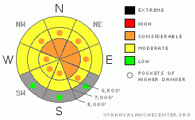
BOTTOM LINE
Danger by aspect and elevation on slopes approaching 35° or steeper.
(click HERE for tomorrow's danger rating)
|
Danger Rose Tutorial
|
There is still a level 3 or Considerable avalanche danger at upper elevations in the backcountry around Logan. Dangerous conditions exist, and triggered persistent slab avalanches are probable on slopes above about 8000' in elevation approaching or steeper than about 35 degrees that didn't already avalanche. Wet avalanches are possible on steep sunny slopes with saturated snow at mid and lower elevations. Careful snowpack evaluation, cautious route finding, and conservative decision making are crucial in avalanche terrain today. |
|
|
CURRENT CONDITIONS |

|
Tony Grove Snotel at 8400' reports around a foot of heavy new snow and a good deal of rain, with 4.5 inches of water in the last 48 hrs. It's chilled to 23 degrees this morning, and there's 85 inches of total snow at the site containing almost160% of average water for the date. The Campbell Scientific weather station at 9700' on Logan Peak reports a still rimed wind sensor and 17 degrees. |
|
|
RECENT ACTIVITY |

|
The wet, warm, and windy weather over the weekend spawned a fairly extensive natural avalanche cycle in the region....... I'll be posting a number of additional observer's photos today.....
See our avalanche list |
|
|
THREAT #1 |

|
| WHERE |
PROBABILITY |
SIZE |
TREND |
|
|
|
|
| |
|
|
Over the next
24 hours.
|
|
|
Well preserved persistent weak layers consisting of frost or surface hoar and small grained faceted snow exist on many slopes in the region. These notorious and tricky persistent weak layers have a very nasty reputation, and are known to be the culprit weakness in the majority of avalanche accidents in the U.S. and Canada... A preserved surface hoar layer is particularly evil, in that avalanches running on it often occur on slopes less steep than other types of avalanches, and slopes can remain in a balanced unstable state for a good while after their initial loading.....
Dangerous avalanche conditions exist at upper and mid elevations where a substantial slab rapidly built up on slopes with these weak layers over the weekend.. Triggered persistent slabs, 1 to 2 feet deep, are still probable today at upper elevations, and dangerous avalanches could be triggered remotely from a distance, or worse, from below. |
|
|
THREAT #2 |

|
| WHERE |
PROBABILITY |
SIZE |
TREND |
|
|
|
|
| |
|
|
Over the next
12 hours.
|
|
|
Cooling temperatures will ease the wet avalanche problem today, but the mid and lower elevation snow is quite saturated..... Sun warmed slopes that did not refreeze well overnight will still be suspect today, and you could trigger wet avalanches on steep lower and mid elevation slopes with saturated snow.... Be wary of trees, gullies and other potential terrain traps. |
|
|
MOUNTAIN WEATHER |

|
Mountain temperatures will rise to a few degrees above freezing, and we could see a bit of sunshine this morning.. Clouds will build this afternoon ahead of the next round of storminess, which will affect the zone tonight.... We'll see increasing southwest winds overnight and 4 to 8 inches of accumulation of lighter (normal) snow is forecast by tomorrow morning. High pressure ridging should bring fairer weather to the mountains later in the week.... |
|
|
GENERAL ANNOUNCEMENTS |
You can view a photo summary of last year's avalanche activity in the Logan Area HERE
I will be update this advisory in the mornings on Monday, Wednesday, Friday, and Saturday, and on other days if backcountry avalanche conditions warrant...
You have the opportunity to participate in the creation of our own community avalanche advisory by submitting avalanche and snow observations. You can also call us at 801-524-5304 or Toby at 435-757-7578, or email by clicking HERE
Donate to your favorite non-profit – The Friends of the Utah Avalanche Center. The UAC depends on contributions from users like you to support our work.
This advisory is from the U.S.D.A. Forest Service, which is solely responsible for its content. This advisory describes general avalanche conditions and local variations always occur. |
|
|
This information does not apply to developed ski areas or highways where avalanche control is normally done. This advisory is from the U.S.D.A. Forest Service, which is solely responsible for its content. This advisory describes general avalanche conditions and local variations always occur. |
|
This advisory provided by the USDA Forest Service, in partnership with:
The Friends of the Utah Avalanche Center, Utah Division of State Parks and Recreation, Utah Division of Emergency Management, Salt Lake County, Salt Lake Unified Fire Authority and the friends of the La Sal Avalanche Center. See our Sponsors Page for a complete list. |
