AVALANCHE WARNING »
Dangerous avalanche conditions are occuring or are imminent.
Backcountry travel in avalanche terrain is not recommended.
|
 |
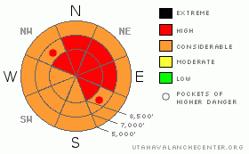
Notice: We’re issuing an Avalanche Warning for the Logan Area Mountains including the Bear River and Wellsville Ranges. Strong winds, warm temperatures, rain, heavy snow, and pre-existing buried weak layers have created very dangerous avalanche conditions and a level 4 or HIGH danger in the backcountry. We recommend that people stay clear of avalanche terrain today. Avoid and stay out from under all steep slopes and obvious or historic avalanche paths. |
|
|
BOTTOM LINE
Danger by aspect and elevation on slopes approaching 35° or steeper.
(click HERE for tomorrow's danger rating)
|
Danger Rose Tutorial
|
There is a level 4 or High avalanche danger in the backcountry, and you should not venture into avalanche terrain today... Very dangerous conditions exist and natural and triggered persistent slab avalanches are likely on upper and mid elevation slopes with buried and preserved weak layers approaching or steeper than about 35 degrees. Potentially dangerous wet avalanches are also likely on steep slopes with saturated snow at mid and lower elevations. You should avoid and stay clear of all steep slopes and obvious or historic avalanche paths and run out zones..... |
|
|
CURRENT CONDITIONS |

|
The tropical moisture tap is wide open, and the fire hose was pointed in our direction yesterday and overnight. Strong southwest winds, warm temperatures, and way too much water likely tipped the scales on many slopes overnight, and others are likely close to the breaking point today. Tony Grove Snotel at 8400' reports around a foot of heavy new snow and a good deal of rain, with 4.1 inches of water in the last 24 hrs. It's a very warm 34 degrees this morning, and there's 87 inches of total snow at the site containing almost160% of average water for the date. The Campbell Scientific weather station at 9700' on Logan Peak reports a rimed wind sensor and 27 degrees. |
|
|
RECENT ACTIVITY |

|
In the past couple days a handful of people have been caught and carried by avalanches in the mountains of Northern Utah. Luckily, so far only minor injuries were reported.... Locally on Saturday, an observer intentionally triggered a shallow persistent wind slab near a ridgeline on a northeast facing slope at around 9000' in elevation. The slide, made up of a few-inch-deep stiff, drifted snow was reported to be around 50 feet wide. Another observer reported seeing a good sized natural avalanche on the east face of Mt. Magog. The estimated one-and-a-half foot deep by at least 100' wide slab probably occurred on Friday. Also, I noticed recent sizable wet activity below the quarry on the south side of Providence Canyon, and on my way down the Canyon yesterday afternoon I watched as one of numerous natural wet avalanches cascaded over cliffs, down a gully, and slammed into the Logan River. Most suspect low elevation north facing paths in mid Logan Canyon slowed evidence of wet activity and more is likely.....
See our avalanche list |
|
|
THREAT #1 |

|
| WHERE |
PROBABILITY |
SIZE |
TREND |
|
|
|
|
| |
|
|
Over the next
24 hours.
|
|
|
An ugly presence lies obscured under the heavy load of moist fresh snow from yesterday and overnight. We've found well preserved persistent weak layers consisting of frost or surface hoar and small grained faceted snow on many slopes in the region. These notorious and tricky persistent weak layers have a very nasty reputation, and are known to be the culprit weakness in the majority of avalanche accidents in the U.S. and Canada... A preserved surface hoar layer is particularly evil, in that avalanches running on it often occur on slopes less steep than other types of avalanches, and slopes can remain in a balanced unstable state for a good while after their initial loading..... Very dangerous avalanche conditions exist at upper and mid elevations where a substantial slab rapidly built up on slopes with these weak layers in the last several hours.... Triggered and natural persistent slabs, 2 to 3 feet deep, are likely today in many areas, and dangerous avalanches could be triggered remotely from a distance, or worse, from below. |
|
|
THREAT #2 |

|
| WHERE |
PROBABILITY |
SIZE |
TREND |

|
|
|
|
| |
|
|
Over the next
12 hours.
|
|
|
Rain and mild temperatures created a significant danger of wet avalanches at mid and lower elevations in the mountains across northern Utah. Significant natural wet avalanches have occurred locally in the past couple days. These wet avalanches indicate that more wet avalanches are likely until temperatures drop enough to freeze up the super saturated snow. Probably not a good day to fish the middle section of the Logan River, where steep slopes above may continue to flush out slushy snow. You certainly want to avoid low elevation terrain traps like gullies, benches, sinks, and trees. |
|
|
MOUNTAIN WEATHER |

|
Temperatures will gradually drop into the mid twenties by this evening in the mountains, and a few more inches of accumulation are possible today as the wet tropical flow tappers down..... We'll see continued west winds tonight, increasing yet again tomorrow, with a bit of sunshine possible and high daytime temperatures slightly above freezing. The next decent shot of snow in the mountains comes tomorrow night, along with some pretty strong west wind...... |
|
|
GENERAL ANNOUNCEMENTS |
You can view a photo summary of last year's avalanche activity in the Logan Area HERE
I will be update this advisory in the mornings on Monday, Wednesday, Friday, and Saturday, and on other days if backcountry avalanche conditions warrant...
You have the opportunity to participate in the creation of our own community avalanche advisory by submitting avalanche and snow observations. You can also call us at 801-524-5304 or Toby at 435-757-7578, or email by clicking HERE
Donate to your favorite non-profit – The Friends of the Utah Avalanche Center. The UAC depends on contributions from users like you to support our work.
This advisory is from the U.S.D.A. Forest Service, which is solely responsible for its content. This advisory describes general avalanche conditions and local variations always occur. |
|
|
This information does not apply to developed ski areas or highways where avalanche control is normally done. This advisory is from the U.S.D.A. Forest Service, which is solely responsible for its content. This advisory describes general avalanche conditions and local variations always occur. |
|
This advisory provided by the USDA Forest Service, in partnership with:
The Friends of the Utah Avalanche Center, Utah Division of State Parks and Recreation, Utah Division of Emergency Management, Salt Lake County, Salt Lake Unified Fire Authority and the friends of the La Sal Avalanche Center. See our Sponsors Page for a complete list. |
