SPECIAL ANNOUNCEMENT |
 |
We've issued a SPECIAL AVALANCHE ADVISORY is for the mountains of northern and central Utah, to include the Bear River Range, the Western Uintas and the Wasatch Plateau. The avalanche danger will be on the rise through the holiday weekend. Dangerous human triggered avalanches will be likely at the mid and upper elevations. Those without excellent avalanche skills should avoid being on or underneath steep mountain slopes. |
|
|
BOTTOM LINE
Danger by aspect and elevation on slopes approaching 35° or steeper.
(click HERE for tomorrow's danger rating)
|
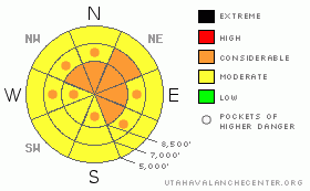
Danger Rose Tutorial
|
The avalanche danger will rise to level 3 or Considerable in the backcountry today. Pockets with a level 3 danger already exist on some slopes, and triggered persistent slab avalanches are probable on drifted slopes approaching or steeper than about 35 degrees. Heavy moist snow, increasing and strong west winds, rain, and mild temperatures will cause the danger to increase and become more widespread through tomorrow. Expect to find heightened avalanche conditions today on drifted slopes at upper and mid-elevations and on lower elevation slopes with saturated snow... Evaluate the snow and terrain carefully and make conservative decisions, especially in steep drifted terrain and on slopes with saturated snow. Given this morning's weather forecast, natural avalanches will likely occur in the Logan Zone overnight tonight or tomorrow, and the danger is likely to rise to level 4... |
|
|
CURRENT CONDITIONS |

|
Warm temperatures, strong westerly winds, and significant accumulations of heavy wet snow will cause a rapidly rising avalanche danger today, tonight, and tomorrow. We'll see developing dangerous avalanche conditions in the backcountry. You'll need to be on top of your game if you head out into the moist storm today, and you will probably not want to venture into avalanche terrain at all overnight and tomorrow
The Tony Grove Snotel at 8400' reports an inch or two of heavy and moist new snow from yesterday and overnight, containing 2/10ths of an inch of water. Its a balmy 30 degrees this morning, and there's 76 inches of total snow at the site containing 138% of average water for the date. The Campbell Scientific weather station at 9700' on Logan Peak is back on line, but the wind sensor appears to be rimed again this morning . It's 23 degrees at the mountain top installation. Ogden Peak is showing average wind speeds in the twenties from the southwest.... |
|
|
RECENT ACTIVITY |

|
In the past couple days a handful of people have been caught and carried by avalanches in the mountains of Northern Utah. Luckily, so far only minor injuries were reported.... Locally, an observer intentionally triggered a shallow persistent wind slab near a ridgeline on a northeast facing slope at around 9000' in elevation. The slide, made up of a few-inch-deep stiff, drifted snow was reported to be around 50 feet wide. Another observer reported seeing a good sized natural avalanche on the east face of Mt. Magog. The estimated one-and-a-half foot deep by at least 100' wide slab probably occurred on Friday. Also, I noticed recent sizable wet activity below the quarry on the south side of Providence Canyon yesterday afternoon.....
See our avalanche list |
|
|
THREAT #1 |

|
| WHERE |
PROBABILITY |
SIZE |
TREND |

|
|
|
|
| |
|
|
Over the next
24 hours.
|
|
|
An ugly presence lies obscured under the few inches of moist fresh snow from Thursday night and the weekend. Last weekend's light snow looks to have nicely preserved weak surface snow consisting of frost or surface hoar and small grained faceted snow on many slopes. These notorious and tricky persistent weak layers have a very nasty reputation, and are known to be the culprit weakness in the majority of avalanche accidents in the U.S. and Canada... A preserved surface hoar layer is particularly evil, in that avalanches running on it often occur on slopes less steep than other types of avalanches, and slopes can remain in a balanced unstable state for a good while after their initial loading.....
Strong winds and heavy moist snowfall will cause the avalanche danger to rise and become more widespread today, and dangerous conditions will develop by this afternoon in many areas.... |
|
|
THREAT #2 |

|
| WHERE |
PROBABILITY |
SIZE |
TREND |

|
|
|
|
| |
|
|
Over the next
8 hours.
|
|
|
Stiff drifts and wind slabs built up in exposed terrain last week, and many of these formed on top of weak layers consisting of preserved frost of surface hoar, sugary faceted snow, and/or thin rime-crust layers. We'd classify these older wind drifts as persistent slabs, but renewed drifting today will overload existing slabs and build new ones.....Watch for and avoid forming and older drifts near ridge lines and in and around terrain features like gullies, cliff-bands, and sub-ridges. Triggered wind slabs and persistent slabs around a foot deep are likely today, and could be triggered remotely from a distance, or worse, from below. |
|
|
THREAT #3 |

|
| WHERE |
PROBABILITY |
SIZE |
TREND |

|
|
|
|
| |
|
|
Over the next
24 hours.
|
|
|
Rain and mild temperatures are creating a significant danger of wet avalanches at lower elevations in the mountains across northern Utah. Roller balls or pin wheels are a sign that the snow is getting saturated.... Wet avalanches indicate that more wet avalanches are likely. You certainly want to avoid low elevation terrain traps if you start to see signs of or trigger wet activity.... |
|
|
MOUNTAIN WEATHER |

|
The National Weather Service has issued a Winter Weather Advisory for our area. Today we'll see intensifying west wind, mild temperatures, and bucket-loads of tropical moisture in the form of heavy snow up high and rain down low... West winds will continue to increase tonight into tomorrow and 9 to up to around 21 inches of snow accumulation is now forecast in the mountains by tomorrow night. The moist northwest flow will continue into the week with a stronger cold front pushing the stagnant air out of the valleys and bringing more significant storminess to the mountains on around Wednesday evening... |
|
|
GENERAL ANNOUNCEMENTS |
You can view a photo summary of last year's avalanche activity in the Logan Area HERE
I will be update this advisory in the mornings on Monday, Wednesday, Friday, and Saturday, and on other days if backcountry avalanche conditions warrant...
You have the opportunity to participate in the creation of our own community avalanche advisory by submitting avalanche and snow observations. You can also call us at 801-524-5304 or Toby at 435-757-7578, or email by clicking HERE
Donate to your favorite non-profit – The Friends of the Utah Avalanche Center. The UAC depends on contributions from users like you to support our work.
This advisory is from the U.S.D.A. Forest Service, which is solely responsible for its content. This advisory describes general avalanche conditions and local variations always occur. |
|
|
This information does not apply to developed ski areas or highways where avalanche control is normally done. This advisory is from the U.S.D.A. Forest Service, which is solely responsible for its content. This advisory describes general avalanche conditions and local variations always occur. |
|
This advisory provided by the USDA Forest Service, in partnership with:
The Friends of the Utah Avalanche Center, Utah Division of State Parks and Recreation, Utah Division of Emergency Management, Salt Lake County, Salt Lake Unified Fire Authority and the friends of the La Sal Avalanche Center. See our Sponsors Page for a complete list. |
