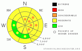
BOTTOM LINE
Danger by aspect and elevation on slopes approaching 35° or steeper.
(click HERE for tomorrow's danger rating)
|
Danger Rose Tutorial
|
The overall danger remains level 2 or Moderate, with heightened avalanche conditions on drifted slopes at upper and mid-elevations and on lower elevation slopes with saturated snow... Pockets with a level 3 danger may exist on some slopes with shallowly buried weak layers and significant deposits of recently drifted snow.. Triggered wind slab avalanches are probable on drifted slopes approaching or steeper than about 35 degrees. You'll find safer conditions and alower danger in sheltered areas. Evaluate the snow and terrain carefully and make conservative decisions, especially in steep drifted terrain and on slopes with saturated snow. |
|
|
CURRENT CONDITIONS |

|
Weak surface snow is widespread in the region and preserved by a few inches of light snow, and it looks as though we may be set up for a problem with tricky persistent slabs as we plow through the first month of 2011... The Tony Grove Snotel at 8400' reports a couple more inches inches of heavy and moist new snow from yesterday and overnight, containing 3/10ths of an inch of water. Its a balmy 29 degrees this morning, and there's 77 inches of total snow at the site containing 140% of average water for the date. The Campbell Scientific weather station at 9700' on Logan Peak is back on line, but the wind sensor appears to be rimed again this morning . It's 22 degrees at the mountain top installation. Ogden Peak recorded 15 to 20 mph average wind speeds from the west-northwest
|
|
|
RECENT ACTIVITY |

|
I intentionally triggered a nice wind slab late Thursday afternoon with a deep turn in drifted mid-elevation terrain on the Steam Mill/White Pine Canyon Ridgeline. The stiff wind slab avalanche on a northeast facing slope at around 7500' in elevation was around a foot deep and a hundred feet wide, but it didn't run far in fairly low angled terrain. A bit lower on the same ridge, I remote triggered at least two more similar pockets from a good distance away....(see report) Yesterday, we received a report of similar remote triggered activity near a mid elevation ridgeline in the Wood Camp area. These and several similar triggered slides in the Wasatch Range are typical of avalanches running on buried surface hoar. |
|
|
THREAT #1 |

|
| WHERE |
PROBABILITY |
SIZE |
TREND |
|
|
|
|
| |
|
|
Over the next
24 hours.
|
|
|
Stiff drifts and wind slabs built up in exposed terrain over the last few days, and many of these formed on top of weak layers consisting of preserved frost of surface hoar, sugary faceted snow, and/or thin rime-crust layers. Watch for and avoid drifts near ridge lines and in and around terrain features like gullies, cliff-bands, and sub-ridges. Triggered wind slabs around a foot deep are likely today, and could be triggered remotely from a distance, or worse, from below. |
|
|
THREAT #2 |

|
| WHERE |
PROBABILITY |
SIZE |
TREND |
|
|
|
|
| |
|
|
Over the next
48 hours.
|
|
|
Last week's light snow looks to have nicely preserved weak surface snow consisting of frost or surface hoar and small grained faceted snow on many slopes. These notorious and tricky persistent weak layers have a very nasty reputation, and are known to be the culprit weakness in the majority of avalanche accidents in the U.S. and Canada... A preserved surface hoar layer is particularly evil, in that avalanches running on it often occur on slopes less steep than other types of avalanches, and slopes can remain in a balanced unstable state for a good while after their initial loading..... |
|
|
THREAT #3 |

|
| WHERE |
PROBABILITY |
SIZE |
TREND |
|
|
|
|
| |
|
|
Over the next
24 hours.
|
|
|
Rain and mild temperatures are creating a danger of wet avalanches at lower elevations in the mountains across northern Utah. Roller balls or pin wheels are a sign that the snow is getting saturated.... Wet avalanches indicate that more wet avalanches are likely. You certainly want to avoid low elevation terrain traps if you start to see signs of or trigger wet activity.... |
|
|
MOUNTAIN WEATHER |

|
We'll see a bit more snowfall in the mountains today, but little in the way of accumulation, as a moist and mild northwest flow sets up over our region.... Periods of light snowfall are also likely tonight, and temperatures will fall to around 20 degrees. Expect increasing and substantial westerly winds on Sunday ahead of more productive shot of snow Sunday afternoon into Monday, with around a foot of accumulation possible...... |
|
|
GENERAL ANNOUNCEMENTS |
You can view a photo summary of last year's avalanche activity in the Logan Area HERE
I will be update this advisory in the mornings on Monday, Wednesday, Friday, and Saturday, and on other days if backcountry avalanche conditions warrant...
You have the opportunity to participate in the creation of our own community avalanche advisory by submitting avalanche and snow observations. You can also call us at 801-524-5304 or Toby at 435-757-7578, or email by clicking HERE
Donate to your favorite non-profit – The Friends of the Utah Avalanche Center. The UAC depends on contributions from users like you to support our work.
This advisory is from the U.S.D.A. Forest Service, which is solely responsible for its content. This advisory describes general avalanche conditions and local variations always occur. |
|
|
This information does not apply to developed ski areas or highways where avalanche control is normally done. This advisory is from the U.S.D.A. Forest Service, which is solely responsible for its content. This advisory describes general avalanche conditions and local variations always occur. |
|
This advisory provided by the USDA Forest Service, in partnership with:
The Friends of the Utah Avalanche Center, Utah Division of State Parks and Recreation, Utah Division of Emergency Management, Salt Lake County, Salt Lake Unified Fire Authority and the friends of the La Sal Avalanche Center. See our Sponsors Page for a complete list. |
