BOTTOM LINE
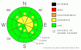
Danger by aspect and elevation on slopes approaching 35° or steeper.
(click HERE for tomorrow's danger rating)
|
Danger Rose Tutorial
|
There is a level 2 or Moderate danger and heightened avalanche conditions exist on drifted slopes in the backcountry. You might trigger fresh or forming wind slabs on steep slopes at upper and mid elevations in exposed terrain. You'll find safer conditions and a level 1 (or Low) danger in sheltered and lower elevation areas. Use normal caution and continue following safe travel protocols, but evaluate the snow and terrain carefully, especially on steep drifted slopes. |
|
|
CURRENT CONDITIONS |

|
Wind, sun, and rime-crusts exist in many areas, now capped by a few inches of fresh light snow from the last few days. In many areas, the new snow looks to have nicely preserved weak surface snow consisting of insidious frost or surface hoar and small grained faceted snow on many slopes. The Campbell Scientific weather station at 9700' on Logan Peak is back on line, and we're reading sustained southwest winds averaging around 20 mph overnight and this morning. It's 14 degrees at the mountain top installation. The Tony Grove Snotel at 8400' reports 3 inches of new snow from Monday afternoon, with 2/10ths of an inch of water. Its a pleasant 20 degrees this morning, and there's 75 inches of total snow at the site containing 140% of average water for the date. |
|
|
RECENT ACTIVITY |

|
Yesterday, folks reported shallow and manageable soft wind slab activity on drifted slopes in most mountain areas along the front, from Provo to Logan. Locally, we triggered several small wind slabs yesterday up in the Wellsville Mountain Wilderness.... One was mid-slope on the lee side of a spur in the huge bed-surface of the 12/29/2010 Rattlesnake Canyon Avalanche (more photos). I triggered the 1' deep and 30' wide soft slab with a slope-cut as we traversed off the Mitton Peak Face at around 7600'. By the looks of things, and since significant surface drifting was still occurring as we left the ridge late yesterday afternoon, the danger of wind slab avalanches appears to be rising and becoming more widespread in exposed terrain...
|
|
|
THREAT #1 |

|
| WHERE |
PROBABILITY |
SIZE |
TREND |

|
|
|
|
| |
|
|
Over the next
24 hours.
|
|
|
Watch for and avoid fresh and forming drifts near ridge lines and in and around terrain features like gullies, cliff-bands, and sub-ridges. The danger of wind slab avalanches in exposed terrain will likely continue to increase a bit in the next couple days, with fairly sustained south and west winds forecast. Triggered wind slabs are likely to become harder, broader, and less manageable.. |
|
|
THREAT #2 |

|
| WHERE |
PROBABILITY |
SIZE |
TREND |

|
|
|
|
| |
|
|
Over the next
48 hours.
|
|
|
Weak surface snow is widespread in the region and preserved by a few inches of light snow. It appears as though we will probably only get small quantities of snowfall in the next few days, and it looks as though we may be set up for a problem with tricky persistent slabs as we plow through the first month of 2011... |
|
|
MOUNTAIN WEATHER |

|
We'll see clouds today and continued moderate southwest winds. Temperatures will maintain readings close to 20 degrees in the mountains, and we may see a few snowflakes this afternoon. A chance of snow and sustained southwest wind will continue through tonight. Light snow will develop tomorrow ahead of a weak frontal passage tomorrow night, with 3 to 6 inches forecast to accumulate by Friday morning. A somewhat moist northwest flow will keep a threat of snow heading into the weekend with more accumulating snow likely during the Sunday Monday time-frame..... |
|
|
GENERAL ANNOUNCEMENTS |
You can view a photo summary of last year's avalanche activity in the Logan Area HERE
I will be update this advisory in the mornings on Monday, Wednesday, Friday, and Saturday, and on other days if backcountry avalanche conditions warrant...
Send us your avalanche and snow observations. You can also call me at 435-757-7578, or email to uac@utahavalanchecenter.org
Donate to your favorite non-profit – The Friends of the Utah Avalanche Center. The UAC depends on contributions from users like you to support our work.
This advisory is from the U.S.D.A. Forest Service, which is solely responsible for its content. This advisory describes general avalanche conditions and local variations always occur. |
|
|
This information does not apply to developed ski areas or highways where avalanche control is normally done. This advisory is from the U.S.D.A. Forest Service, which is solely responsible for its content. This advisory describes general avalanche conditions and local variations always occur. |
|
This advisory provided by the USDA Forest Service, in partnership with:
The Friends of the Utah Avalanche Center, Utah Division of State Parks and Recreation, Utah Division of Emergency Management, Salt Lake County, Salt Lake Unified Fire Authority and the friends of the La Sal Avalanche Center. See our Sponsors Page for a complete list. |
