BOTTOM LINE
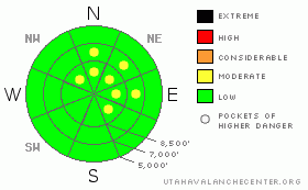
Danger by aspect and elevation on slopes approaching 35° or steeper.
(click HERE for tomorrow's danger rating)
|
Danger Rose Tutorial
|
There is a level 1 or Low danger in the backcountry around Logan. Most slopes are stable and avalanches are generally unlikely. You still might find a few shallow fresh or forming wind slabs in isolated steep terrain exposed to drifting, and dry loose sluffs are still possible on very steep slopes with weak surface snow. Use normal caution and continue following safe travel protocols. |
|
|
CURRENT CONDITIONS |

|
We found some pretty good snow yesterday on lower elevation west facing slopes, but wind, sun, and rime-crusts exist in many areas, and all this is now capped by an inch or two of fresh snow from Saturday Night. The new snow looks to have nicely preserved weak surface snow consisting of notorious frost or surface hoar and small grained faceted snow on many slopes, and the next storm is likely to bring down the house...
The Campbell Scientific weather station at 9700' on Logan Peak is back on line, but the wind sensor appears to be rimed up. It's 3 degrees below zero at the station with winds look to be from the north. Mt. Ogden reports moderate northwest winds, averaging in the low teens overnight. The Tony Grove Snotel at 8400' reports 1 degree this morning and there's 76 inches of total snow at the site containing 144% of average water for the date. |
|
|
RECENT ACTIVITY |

|
Locally, it's been quiet avalanche-wise, and few avalanches have been reported since last year's extensive natural cycle, and no fresh activity in the last week. I took an avalanche class up to the Wellsville Mountain Wilderness over the weekend for a look at a huge pile of debris up in Rattlesnake Canyon.... Somewhat difficult to describe, but it's as though a glacier suddenly formed in the evening of 12-29-2010 as every slope in the drainage naturally came down into the canyon bottom.... (View observation here) |
|
|
THREAT #1 |

|
| WHERE |
PROBABILITY |
SIZE |
TREND |

|
|
|
|
| |
|
|
Over the next
24 hours.
|
|
|
Watch for and avoid fresh and forming wind slabs near ridge lines and in and around terrain features like gullies, cliff-bands, and sub-ridges. The danger of shallow wind slab avalanches in exposed terrain will likely increase a bit in the next couple days and rapidly with any significant increase in winds. |
|
|
THREAT #2 |

|
| WHERE |
PROBABILITY |
SIZE |
TREND |

|
|
|
|
| |
|
|
Over the next
24 hours.
|
|
|
Loose dry sluffs are gradually becoming bigger as the surface snow continues to lose strength in shady terrain... These are manageable for the most part, but could certainly become a problem, especially if you're hit from above. Make sure no one is below you when you commit to a slope, and be especially wary of steep slopes where you could be washed into a terrain trap like a gully, sink hole, or trees below. |
|
|
MOUNTAIN WEATHER |

|
We'll see cold temperatures all day in the mountains under a cold north flow.. Temperatures may rise into the single digits around midday and we may taste a few snowflakes under mostly overcast skies. Temperatures will begin to rise in the mountains tomorrow, with cold air, fog, and smog likely to be trapped in Cache Valley. We'll see increasing winds, milder temperatures, and moist snowfall beginning Wednesday, which will probably cause the avalanche danger to rise significantly in the backcountry.... |
|
|
GENERAL ANNOUNCEMENTS |
You can view a photo summary of last year's avalanche activity in the Logan Area HERE
I will be update this advisory in the mornings on Monday, Wednesday, Friday, and Saturday, and on other days if backcountry avalanche conditions warrant...
Send us your avalanche and snow observations. You can also call me at 435-757-7578, or email to uac@utahavalanchecenter.org
Donate to your favorite non-profit – The Friends of the Utah Avalanche Center. The UAC depends on contributions from users like you to support our work.
This advisory is from the U.S.D.A. Forest Service, which is solely responsible for its content. This advisory describes general avalanche conditions and local variations always occur. |
|
|
This information does not apply to developed ski areas or highways where avalanche control is normally done. This advisory is from the U.S.D.A. Forest Service, which is solely responsible for its content. This advisory describes general avalanche conditions and local variations always occur. |
|
This advisory provided by the USDA Forest Service, in partnership with:
The Friends of the Utah Avalanche Center, Utah Division of State Parks and Recreation, Utah Division of Emergency Management, Salt Lake County, Salt Lake Unified Fire Authority and the friends of the La Sal Avalanche Center. See our Sponsors Page for a complete list. |
