BOTTOM LINE
Danger by aspect and elevation on slopes approaching 35° or steeper.
(click HERE for tomorrow's danger rating)
|
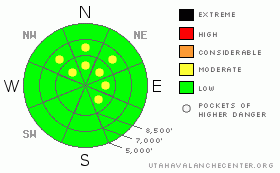
Danger Rose Tutorial
|
There is a level 1 or Low danger on most slopes in the backcountry around Logan, and avalanches are generally unlikely. There are, however, still a few pockets with a level 2 or Moderate danger, and heightened avalanche conditions persist in drifted terrain where you might trigger stiff older or fresh forming wind slabs on very steep exposed slopes. Loose snow avalanches are also possible on very steep slopes with loose recrystallized surface snow. Use normal caution and continue following safe travel protocols, but evaluate the snow and terrain carefully, especially on very steep slopes in drifted areas or in big terrain.... |
|
|
CURRENT CONDITIONS |

|
Thanks to the folks at Campbell Scientific for maintaining Logan Peak and the rest of their local network of weather stations in the area.. Glen had to scale the tall tower on top of Logan Peak to re-attach the all important radio antenna that had become unplugged due to vibrations caused by the always gusty winds blowing through the steal structure.. The station at 9700' is back on line this morning, and I'm reading 24 degrees with 15+ mph average winds from the west-northwest.. The Tony Grove Snotel at 8400' reports a balmy 28 degrees this morning and there's 74 inches of total snow at the site containing 149% of average water for the date. You'll find wind or sun-crusts on many exposed slopes, but nice recrystallized powder stashes are hidden in sheltered shady terrain across the region and can still be found at all elevations..... |
|
|
RECENT ACTIVITY |

|
Locally, it's been quiet avalanche-wise, and no new avalanches have been reported for the last week or so... On Wednesday afternoon my partner triggered and was pushed a little ways by a shallow hard wind slab that was pasted on the steep wall of our exit gully. The 2" to 10" deep and around 25' wide hard slab stayed intact and only slid a couple feet before coming to an abrupt stop. The dense, freshly drifted slab had formed on top of weak frost or surface hoar at fairly low elevations, around 6500' in the Southern Wellsvilles.... Yesterday we noticed a couple fresh natural loose slides on the north side of Providence Canyon... Couldn't really tell from a distance, but looked like moist snow off an upper elevation south facing slope and dry faceted snow in a lower elevation sluff, also on the north side of the canyon.... |
|
|
THREAT #1 |

|
| WHERE |
PROBABILITY |
SIZE |
TREND |

|
|
|
|
| |
|
|
Over the next
24 hours.
|
|
|
The stiff wind slabs that formed earlier in the week appear to be well bonded to the underlying snow, and we couldn't get any to budge even in very steep exposed terrain yesterday...A few of these could still be sensitive on very steep slopes where they built on weak surface snow... And today's cold front will bring more wind and possibly a couple inches of snowfall, so fresh drifts and shallow wind slabs will form again in exposed terrain. Watch for and avoid stiff older drifts or forming wind slabs near ridge lines and in and around terrain features like gullies, cliff-bands, and sub-ridges. The danger of wind slab avalanches will likely increase a bit over the weekend, with increasing west winds today and a few inches of snowfall possible... |
|
|
THREAT #2 |

|
| WHERE |
PROBABILITY |
SIZE |
TREND |
|
|
|
|
| |
|
|
Over the next
8 hours.
|
|
|
Falling temperatures will probably keep a lid on any wet activity today, but loose dry sluffs are gradually becoming bigger as the surface snow continues to lose strength in shady terrain... These are manageable for the most part, but could certainly become a problem, especially if you're hit from above. Make sure no one is below you when you commit to a slope, and be especially wary of steep slopes where you could be washed into a terrain trap like a gully, sink hole, or trees below. |
|
|
MOUNTAIN WEATHER |

|
Expect the fog and smog in Cache Valley to be mixed out today, with increasing west winds and clouds in the mountains. A bit of snow is possible this afternoon, and 1 to 3 inches of snowfall is forecast. .. A couple more inches may accumulate overnight and the winds will shift around from the northwest... The inversion will build in again briefly as the cold front moves off to the southeast tomorrow.. A moist and increasingly mild northwest flow will develop next week, and periods of snow are likely as mostly weak disturbances ripple across Northern Utah.... |
|
|
GENERAL ANNOUNCEMENTS |
You can view a photo summary of last year's avalanche activity in the Logan Area HERE
I will be update this advisory in the mornings on Monday, Wednesday, Friday, and Saturday, and on other days if backcountry avalanche conditions warrant...
Send us your avalanche and snow observations. You can also call me at 435-757-7578, or email to uac@utahavalanchecenter.org
Donate to your favorite non-profit – The Friends of the Utah Avalanche Center. The UAC depends on contributions from users like you to support our work.
This advisory is from the U.S.D.A. Forest Service, which is solely responsible for its content. This advisory describes general avalanche conditions and local variations always occur. |
|
|
This information does not apply to developed ski areas or highways where avalanche control is normally done. This advisory is from the U.S.D.A. Forest Service, which is solely responsible for its content. This advisory describes general avalanche conditions and local variations always occur. |
|
This advisory provided by the USDA Forest Service, in partnership with:
The Friends of the Utah Avalanche Center, Utah Division of State Parks and Recreation, Utah Division of Emergency Management, Salt Lake County, Salt Lake Unified Fire Authority and the friends of the La Sal Avalanche Center. See our Sponsors Page for a complete list. |
