BOTTOM LINE
Danger by aspect and elevation on slopes approaching 35° or steeper.
(click HERE for tomorrow's danger rating)
|
Danger Rose Tutorial
|
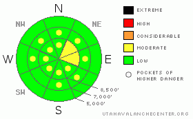
There is a level 1 or Low danger on most slopes in the backcountry around Logan, and avalanches are generally unlikely, especially in more sheltered and lower elevation areas. There are, however, still pockets with a level 2 or Moderate danger, and heightened avalanche conditions persist in drifted upper elevation terrain where you might trigger fresh or older wind slabs on exposed slopes steeper than about 35 degrees. Loose snow avalanches are also possible on steep slopes and can be more dangerous on slopes with a long sustained pitch or above terrain traps. Use normal caution and continue following safe travel protocols, but evaluate the snow and terrain carefully in drifted areas or big terrain. |
|
|
CURRENT CONDITIONS |

|
You'll find the snow jacked by wind or sun-crusts on many exposed slopes, but nice recrystallized powder stashes are hidden in sheltered terrain and can still be found at all elevations.... The Tony Grove Snotel at 8400' reports 13 degrees and no new snow. There's 78 inches of total snow at the site containing 157% of average water for the date. Mt Ogden is reading 7 degrees this morning, with 25-35 mph southwest and west winds reported from overnight and this morning.... |
|
|
RECENT ACTIVITY |

|
One of the Ogden Area ski areas reports triggering a few wind slabs at upper elevations in exposed terrain and near cliff bands yesterday....
Locally, we're still finding evidence of a widespread natural cycle a week ago. In some areas, crowns are seen in somewhat unexpected places and at fairly low elevations... Many long running slides ran in the Logan Peak and Wellsville Mountain Wilderness, with debris piles at the bottom of nearly every path in some drainages....Other areas, like the Central Bear River Range, showed more spotty results, with a few large naturals here and there. Avalanche activity quieted down significantly since the storm, and no triggered avalanches have been reported since the weekend.... One observer reported a large fresh looking crown above Birch Canyon in the Mount Naomi Wilderness visible from the valley on Monday, but the timing and trigger of this remain a mystery. |
|
|
THREAT #1 |

|
| WHERE |
PROBABILITY |
SIZE |
TREND |

|
|
|
|
| |
|
|
Over the next
24 hours.
|
|
|
Northwest winds picked up a bit yesterday and will resume again today with a little fresh snow in the mix. The wind is drifting the recrystallized surface snow into lee slope starting zones and deceleration/deposition areas. Freshly formed shallow wind slabs are possible in exposed terrain, and in some areas drifts may be building up on weak surface snow consisting of frost or surface hoar, which has been reported across the region. Watch for and avoid stiffer drifted snow or wind slabs near ridge lines and in and around terrain features like gullies, cliff-bands, and sub-ridges. You might trigger fresh or older wind slab avalanches 1 to 2 feet deep on drifted slopes steeper than about 35 degrees.
Be particularly wary on steep drifted slopes above trees or other potential terrain traps like rocks or abrupt benches.... |
|
|
THREAT #2 |

|
| WHERE |
PROBABILITY |
SIZE |
TREND |

|
|
|
|
| |
|
|
Over the next
24 hours.
|
|
|
Sizable dry loose avalanches or sluffs are possible on steep slopes. We've been getting daily reports of triggered loose slides, and they are gradually becoming bigger as the surface snow continues to lose strength... Dry sluffs are manageable for the most part, but could certainly be a problem if you're hit from above. Make sure no one is below you when you commit to a slope, and be especially wary of steep slopes where you could be washed into a terrain trap like a gully, sink hole, or trees below. |
|
|
MOUNTAIN WEATHER |

|
A weak storm system passing to our north will affect our region today, and we'll see westerly winds and increasing cloud cover , with a chance of a bit of accumulating snowfall this afternoon and evening. A high pressure system will move over the area for Thursday and Friday, and the inversion will strengthen. Expect fog and smog in Cache Valley with fair and warmer conditions in the mountains. A quick hitting but potentially intense storm will mix the soup out of the Cache and bring a good chance of snow to the mountains over the weekend, with a frontal passage scheduled for late Saturday night or early Sunday morning. |
|
|
GENERAL ANNOUNCEMENTS |
You can view a photo summary of last year's avalanche activity in the Logan Area HERE
I will be update this advisory in the mornings on Monday, Wednesday, Friday, and Saturday, and on other days if backcountry avalanche conditions warrant...
Send us your avalanche and snow observations. You can also call me at 435-757-7578, or email to uac@utahavalanchecenter.org
Donate to your favorite non-profit – The Friends of the Utah Avalanche Center. The UAC depends on contributions from users like you to support our work.
This advisory is from the U.S.D.A. Forest Service, which is solely responsible for its content. This advisory describes general avalanche conditions and local variations always occur. |
|
|
This information does not apply to developed ski areas or highways where avalanche control is normally done. This advisory is from the U.S.D.A. Forest Service, which is solely responsible for its content. This advisory describes general avalanche conditions and local variations always occur. |
|
This advisory provided by the USDA Forest Service, in partnership with:
The Friends of the Utah Avalanche Center, Utah Division of State Parks and Recreation, Utah Division of Emergency Management, Salt Lake County, Salt Lake Unified Fire Authority and the friends of the La Sal Avalanche Center. See our Sponsors Page for a complete list. |
