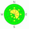
BOTTOM LINE
Danger by aspect and elevation on slopes approaching 35° or steeper.
(click HERE for tomorrow's danger rating)
|

Danger Rose Tutorial
|
There is still a level 2 or Moderate danger, and heightened avalanche conditions exist in drifted upper elevation terrain where you might trigger fresh or older wind slabs on exposed slopes steeper than about 35 degrees. You'll find safer conditions and a level 1 (or Low) danger in more sheltered and lower elevation areas... Use normal caution and continue following safe travel protocols, but evaluate the snow and terrain carefully in exposed or drifted areas. |
|
|
CURRENT CONDITIONS |

|
We're still finding very nice powder riding conditions at all elevations and on slopes facing all directions in the backcountry around Logan. The Tony Grove Snotel at 8400' reports 13 degrees and 3 new inches of snow yesterday. There's 80 inches of total snow at the site containing 164% of average water for the date. Mt Ogden is reading 11 degrees this morning, with 15-20 mph southwest to west winds reported from overnight.... |
|
|
RECENT ACTIVITY |

|
Backcountry travelers were out in force over the first weekend of 2011 in the mountains of Northern Utah yesterday, and only a very few triggered avalanches were reported. But, several of these were on southerly facing slopes, which are often thought to be safer this time of year.... Of particular interest, a skier triggered a very large slide on an upper elevation south facing slope in the Provo Area Mountains on Saturday. see details here
Locally, a backcountry rider reports triggering a small wind slab avalanche in a chute under the East Face of Mt. Magog in the Tony Grove Area on Friday. The slope released on his second turn in, after a previously attempted slope cut. A few fresh but smallish natural wind slab releases were also reported from exposed upper elevation terrain in the Central Bear River Range. |
|
|
THREAT #1 |

|
| WHERE |
PROBABILITY |
SIZE |
TREND |
|
|
|
|
| |
|
|
Over the next
24 hours.
|
|
|
Freshly formed shallow wind slabs are possible in exposed terrain. It doesn't take much wind to drift the fluffy dried-out surface snow into lee slope starting zones and deceleration/deposition areas. Watch for and avoid stiffer drifted snow or wind slabs near ridge lines and in and around terrain features like gullies, cliff-bands, and sub-ridges. You might trigger fresh or older wind slab avalanches 1 to 2 feet deep on drifted slopes steeper than about 35 degrees. Be particularly wary on steep drifted slopes above trees or other potential terrain traps like rocks or abrupt benches.... |
|
|
THREAT #2 |

|
| WHERE |
PROBABILITY |
SIZE |
TREND |
|
|
|
|
| |
|
|
Over the next
24 hours.
|
|
|
Significant and sizable dry loose avalanches or sluffs are possible on steep slopes. These are likely to be manageable for the most part, but could be a problem if you're hit from above. Make sure no one is below you when you commit to a slope. You'll be wise to avoid steep slopes where you could be washed into a terrain trap like a gully, sink hole, or trees below. |
|
|
MOUNTAIN WEATHER |

|
A weak storm will affect southern and central Utah today, and we'll see warmer mountain temperatures and some clouds up north... We may see a little snowfall in the Tuesday/Wednesday time-frame, but accumulations will probably be quite light...Expect a warming trend in the mountains as a high pressure system takes hold of the weather pattern for the coming work week. The dreaded inversion is likely to keep temperatures cold and trap smog and fog in the Cache as the week progresses. Our next chance for a change in the weather, and a possible storm comes next weekend..... |
|
|
GENERAL ANNOUNCEMENTS |
You can view a photo summary of last year's avalanche activity in the Logan Area HERE
I will be update this advisory in the mornings on Monday, Wednesday, Friday, and Saturday, and on other days if backcountry avalanche conditions warrant...
Send us your avalanche and snow observations. You can also call me at 435-757-7578, or email to uac@utahavalanchecenter.org
Donate to your favorite non-profit – The Friends of the Utah Avalanche Center. The UAC depends on contributions from users like you to support our work.
This advisory is from the U.S.D.A. Forest Service, which is solely responsible for its content. This advisory describes general avalanche conditions and local variations always occur. |
|
|
This information does not apply to developed ski areas or highways where avalanche control is normally done. This advisory is from the U.S.D.A. Forest Service, which is solely responsible for its content. This advisory describes general avalanche conditions and local variations always occur. |
|
This advisory provided by the USDA Forest Service, in partnership with:
The Friends of the Utah Avalanche Center, Utah Division of State Parks and Recreation, Utah Division of Emergency Management, Salt Lake County, Salt Lake Unified Fire Authority and the friends of the La Sal Avalanche Center. See our Sponsors Page for a complete list. |
