BOTTOM LINE
Danger by aspect and elevation on slopes approaching 35° or steeper.
(click HERE for tomorrow's danger rating)
|
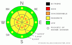
Danger Rose Tutorial
|
There is a level 2 or Moderate danger on most slopes in the Logan Area backcountry. Heightened avalanche conditions exist and you might trigger avalanches on slopes steeper than about 35 degrees in many areas... Also, dangerous avalanche conditions and pockets with a level 3 or Considerable danger remain in drifted upper elevation terrain where you are more likely to trigger fresh wind slabs or older persistent slabs on steep exposed slopes. Careful snowpack evaluation, cautious route finding, and conservative decision making are essential today, especially in drifted upper elevation terrain. |
|
|
CURRENT CONDITIONS |

|
Cold temperatures continue to preserve and dry out the fresh snow, and we will begin 2011 with very nice powder riding conditions at all elevations and on slopes facing all directions in the backcountry around Logan.
The Tony Grove Snotel at 8400' is reporting -3 degrees below zero this morning and no new snow overnight. There's 82 inches of total snow at the site containing 170% of average water for the date. The CSI Logan Peak weather station is down, but Mt Ogden is reading -10 degrees, with 20-30 mph south and west winds reported from overnight.... |
|
|
RECENT ACTIVITY |

|
Backcountry travelers triggered a few avalanches in the mountains of Northern Utah yesterday and one person was caught and carried a short distance.
Locally, a backcountry rider reports triggering a small soft slab avalanche in a chute under the East Face of Mt. Magog in the Tony Grove Area. The slope released on his second turn in, after a previously attempted slope cut. A member of my party easily triggered a broad avalanche Wednesday afternoon in East Miller Bowl, south of Tony Grove Lake. The midweek storm caused active avalanche conditions, and large natural avalanches resulted late Wednesday 12-29-2010. Despite poor visibility and limited frosty views, we've observed large natural avalanches in the Wellsville Mountain Wilderness above Mendon and Wildcat off the Morning Glory Ridge in mid-Cottonwood Canyon in the Mount Naomi Wilderness.... |
|
|
THREAT #1 |

|
| WHERE |
PROBABILITY |
SIZE |
TREND |
|
|
|
|
| |
|
|
Over the next
24 hours.
|
|
|
In the past week we've observed weak frost crystals or surface hoar, weak recrystallized or faceted snow near the surface, and weak and brittle crusts. These are now buried by Wednesday's deep and heavy snow. I have been able to find buried persistent weak layers within the upper meter of the snowpack in many areas, but the distribution is spotty.... Problem is, any avalanche stepping down into hard older snow will likely be unmanageable, dangerous, and potentially destructive.... Keep in mind that recent triggered avalanches in the Central Wasatch Range have occurred on southeast, south, and southwest facing slopes as well as on the more expected slope aspects....
Watch for and avoid stiffer drifted snow or older wind slabs near ridge lines and in and around deposition prone terrain features like gullies, cliff-bands, and sub-ridges. You are likely to trigger older or persitant wind slab avalanches 1 to 3 feet deep on drifted slopes approaching or steeper than about 35 degrees. |
|
|
THREAT #2 |

|
| WHERE |
PROBABILITY |
SIZE |
TREND |

|
|
|
|
| |
|
|
Over the next
24 hours.
|
|
|
Freshly formed shallow wind slabs are possible in exposed terrain. It doesn't take much wind to drift the fluffy dried-out surface snow into lee slope starting zones and deceleration/deposition areas. Significant and sizable dry loose avalanches or sluffs are possible on steep slopes at all elevations. These are likely to be mostly manageable, but could be a problem if you're hit from above and you want to avoid steep slopes where you could be washed into a terrain trap like a gully, sink hole, or trees below. |
|
|
MOUNTAIN WEATHER |

|
It looks like we're in for continued bitterly cold weather for at least today and tonight. We will likely see a bit of snowfall early today as a northern system clips the region, with high mountain temperatures stalled around zero. Temperatures will drop to a couple degrees below zero again tonight. A high pressure system will build into the region for the weekend and mountain temperatures will moderate a bit. A weakening system will move through southern Utah on Tuesday, and there's a chance for some snowfall at that time. There's a good chance the dreaded inversion will develop later in the first week of the New Year..... |
|
|
GENERAL ANNOUNCEMENTS |
You can view a photo summary of last year's avalanche activity in the Logan Area HERE
I will be update this advisory in the mornings on Monday, Wednesday, Friday, and Saturday, and on other days if backcountry avalanche conditions warrant...
Send us your avalanche and snow observations. You can also call me at 435-757-7578, or email to uac@utahavalanchecenter.org
Donate to your favorite non-profit – The Friends of the Utah Avalanche Center. The UAC depends on contributions from users like you to support our work.
This advisory is from the U.S.D.A. Forest Service, which is solely responsible for its content. This advisory describes general avalanche conditions and local variations always occur. |
|
|
This information does not apply to developed ski areas or highways where avalanche control is normally done. This advisory is from the U.S.D.A. Forest Service, which is solely responsible for its content. This advisory describes general avalanche conditions and local variations always occur. |
|
This advisory provided by the USDA Forest Service, in partnership with:
The Friends of the Utah Avalanche Center, Utah Division of State Parks and Recreation, Utah Division of Emergency Management, Salt Lake County, Salt Lake Unified Fire Authority and the friends of the La Sal Avalanche Center. See our Sponsors Page for a complete list. |
