BOTTOM LINE
Danger by aspect and elevation on slopes approaching 35° or steeper.
(click HERE for tomorrow's danger rating)
|
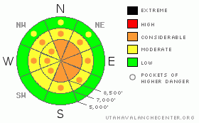
Danger Rose Tutorial
|
Uneven snow accumulations, winds, and patchy weak layer distributions have created complex and widely varied avalanche conditions in the backcountry around Logan. Cold temperatures and new snow settlement appear to be helping with overall stability, while recent heavy accumulations, wind, and natural avalanches indicate that dangerous avalanche conditions exist in some areas... There is a level 3 or Considerable avalanche danger on drifted upper and mid-elevation slopes, and triggered wind slab or persistent slab avalanches are probable on slopes steeper than about 35 degrees in some areas. Many other slopes in the zone have a level 2 or Moderate danger, and triggered avalanches are possible....Careful snowpack evaluation, cautious route finding, and conservative decision making are essential today.... |
|
|
CURRENT CONDITIONS |

|
Cold temperatures are preserving and drying out the fresh snow, and we will finish 2010 with very nice powder riding conditions in the backcountry. The Tony Grove Snotel at 8400' is reporting -4 degrees below zero this morning and no new snow overnight. There's 83 inches of total snow at the site containing 174% of average water for the date. The CSI Logan Peak weather station is down, but Mt Ogden is also reading -4 degrees with a north breeze this morning. |
|
|
RECENT ACTIVITY |

|
Wednesday's storm created active avalanche conditions and we've received reports of numerous large natural and triggered avalanches in the mountains of Northern Utah.... Ski Area snow safety crews in the Ogden Area Mountains triggered a number of fairly large and fast running avalanches yesterday with explosives and slope cuts...
Locally, my party easily triggered a fairly broad soft slab avalanche Wednesday afternoon south of Tony Grove Lake... The avalanche on a north facing slope at around 8700' in elevation involved new and wind deposited snow failing on a weak layer consisting of frost or surface hoar and small-grained sugary snow that was recrystallized while on the surface earlier in the week. The avalanche was 1 to 2.5 feet deep and at least 300' wide. Poor visibility prevented views of the Bear River Range high country, but I did note some evidence of natural activity on the west side of Tony Grove Lake... Brief clearing yesterday evening gave us a glimpse of much more significant natural activity on the large east facing avalanche paths above Mendon in the Wellsville Mountain Wilderness. Hopefully we'll be able to get a better view today... |
|
|
THREAT #1 |

|
| WHERE |
PROBABILITY |
SIZE |
TREND |

|
|
|
|
| |
|
|
Over the next
24 hours.
|
|
|
Watch for and avoid stiffer drifted snow or potential wind slabs near ridge lines and in and around deposition prone terrain features like gullies, cliff-bands, and sub-ridges. You are likely to trigger wind slab avalanches 1 to 3 feet deep on drifted slopes approaching or steeper than about 35 degrees. |
|
|
THREAT #2 |

|
| WHERE |
PROBABILITY |
SIZE |
TREND |
|
|
|
|
| |
|
|
Over the next
24 hours.
|
|
|
In the past week we've observed weak frost crystals or surface hoar, weak recrystallized or faceted snow near the surface, and weak and brittle crusts. These are now buried by Wednesday's deep and heavy snow. I have been able to find buried persistent weak layers within the upper meter of the snowpack in many areas, but the distribution is spotty.... Problem is, any avalanche stepping down into hard older snow will likely be unmanageable, dangerous, and potentially destructive.... |
|
|
MOUNTAIN WEATHER |

|
It looks like we're in for some bitterly cold weather in the next few days. We will likely see a bit of snowfall today with high mountain temperatures around zero. Temperatures will drop to 10 below tonight, with a few more inches of snowfall possible. A high pressure system will build into the region for the weekend and overall temperatures will stay fairly cold, and there's a good chance for the dreaded inversion to develop. Models begin to disagree about next week's weather, but there is a good possibility of a prolonged high pressure pattern in our future.... |
|
|
GENERAL ANNOUNCEMENTS |
We are offering a level 1 backcountry avalanche certification class with the USU Outdoor Recreation Program starting on Thursday, January 6... The class follows American Avalanche Association guidelines, and is overseen by AAA certified avalanche instructor and Utah Avalanche Center backcountry avalanche forecaster, Toby Weed. More Details
You can view a photo summary of last year's avalanche activity in the Logan Area HERE
I will be update this advisory in the mornings on Monday, Wednesday, Friday, and Saturday, and on other days if backcountry avalanche conditions warrant...
Send us your avalanche and snow observations. You can also call me at 435-757-7578, or email to uac@utahavalanchecenter.org
Donate to your favorite non-profit – The Friends of the Utah Avalanche Center. The UAC depends on contributions from users like you to support our work.
This advisory is from the U.S.D.A. Forest Service, which is solely responsible for its content. This advisory describes general avalanche conditions and local variations always occur. |
|
|
This information does not apply to developed ski areas or highways where avalanche control is normally done. This advisory is from the U.S.D.A. Forest Service, which is solely responsible for its content. This advisory describes general avalanche conditions and local variations always occur. |
|
This advisory provided by the USDA Forest Service, in partnership with:
The Friends of the Utah Avalanche Center, Utah Division of State Parks and Recreation, Utah Division of Emergency Management, Salt Lake County, Salt Lake Unified Fire Authority and the friends of the La Sal Avalanche Center. See our Sponsors Page for a complete list. |
