AVALANCHE WARNING »
Dangerous avalanche conditions are occuring or are imminent.
Backcountry travel in avalanche terrain is not recommended.
|
 |
Notice: We've issued an AVALANCHE WARNING for all the mountains of central and northern Utah. The current snow storm has added a significant amount of snow causing large natural avalanches. Dangerous avalanche conditions will remain in the backcountry through today. Avoid travel on or below steep slopes and stay clear of obvious or historic avalanche paths. This warning does not include ski areas or highways where avalanche control is normally done. |
|
|
BOTTOM LINE
Danger by aspect and elevation on slopes approaching 35° or steeper.
(click HERE for tomorrow's danger rating)
|
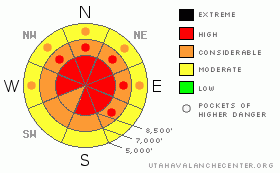
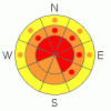
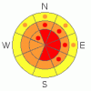
Danger Rose Tutorial
|
There is a level 4 or High avalanche danger on many slopes in the backcountry around Logan. Natural avalanches probably occurred overnight in many areas, and numerous steep slopes that did not already avalanche are very likely to still be unstable today. Triggered storm snow and wind slab avalanches are likely and more naturals are possible on slopes approaching or steeper than about 35 degrees. Avoid and stay out from under steep slopes and obvious or historic avalanche paths..... |
|
|
CURRENT CONDITIONS |

|
Very dangerous avalanche conditions in the backcountry dictate that we should avoid avalanche terrain today... The Ben Lomond Peak Snotel, east of North Ogden, reports 7 inches of water in close to three feet of heavy and moist new snow in the past thirty hours. Mt Ogden is reading moderate northwest winds this morning after sustained 50-60 mph south and west winds yesterday. The Tony Grove Snotel at 8400' reports 6 degrees and around a foot of new snow, containing 1.5 inches of water. There's 85 inches of total snow at the site containing 177% of average water for the date. |
|
|
RECENT ACTIVITY |

|
We've received reports of numerous large natural and triggered avalanches in the mountains of Northern Utah.... Locally, my party easily triggered a fairly broad soft slab avalanche yesterday afternoon south of Tony Grove Lake...The avalanche on a north facing slope at around 8700' in elevation involved new and wind deposited snow failing on a weak layer consisting of frost or surface hoar and small-grained sugary snow that was recrystallized while on the surface earlier in the week. The avalanche was 1 to 1.5 feet deep and around 300' wide. |
|
|
THREAT #1 |

|
| WHERE |
PROBABILITY |
SIZE |
TREND |
|
|
|
|
| |
|
|
Over the next
24 hours.
|
|
|
We've observed weak frost crystals or surface hoar, weak recrystallized or faceted snow near the surface, and weak and brittle crusts in the past few days. Many areas received significant accumulations of heavy new snow, which is not sticking very well to the weak stuff that was on or near the snow surface. Soft Slab avalanches are likely on many slopes today.... |
|
|
THREAT #2 |

|
| WHERE |
PROBABILITY |
SIZE |
TREND |
|
|
|
|
| |
|
|
Over the next
24 hours.
|
|
|
Watch for and avoid stiffer drifted snow or potential wind slabs near ridge lines and in and around deposition prone terrain features like gullies, cliff-bands, and sub-ridges. You are likely to trigger wind slab avalanches 2 to 4 feet deep on drifted slopes approaching or steeper than about 35 degrees. |
|
|
MOUNTAIN WEATHER |

|
The heavy snowfall tapered off overnight in far Northern Utah, but we may see a few more flurries today... It's cold this morning, with mountain weather stations reporting single digit temperatures....Expect cold mountain temperatures, cloudiness and snow showers through tomorrow. A high pressure system will move over the region for the weekend, but very cold temperatures will persist into the New Year, with seriously cold weather and -17 degrees forecast for the last night of 2010. |
|
|
GENERAL ANNOUNCEMENTS |
We are offering a level 1 backcountry avalanche certification class with the USU Outdoor Recreation Program starting on Thursday, January 6... The class follows American Avalanche Association guidelines, and is overseen by AAA certified avalanche instructor and Utah Avalanche Center backcountry avalanche forecaster, Toby Weed. More Details
You can view a photo summary of last year's avalanche activity in the Logan Area HERE
I will be update this advisory in the mornings on Monday, Wednesday, Friday, and Saturday, and on other days if backcountry avalanche conditions warrant...
Send us your avalanche and snow observations. You can also call me at 435-757-7578, or email to uac@utahavalanchecenter.org
Donate to your favorite non-profit – The Friends of the Utah Avalanche Center. The UAC depends on contributions from users like you to support our work.
This advisory is from the U.S.D.A. Forest Service, which is solely responsible for its content. This advisory describes general avalanche conditions and local variations always occur. |
|
|
This information does not apply to developed ski areas or highways where avalanche control is normally done. This advisory is from the U.S.D.A. Forest Service, which is solely responsible for its content. This advisory describes general avalanche conditions and local variations always occur. |
|
This advisory provided by the USDA Forest Service, in partnership with:
The Friends of the Utah Avalanche Center, Utah Division of State Parks and Recreation, Utah Division of Emergency Management, Salt Lake County, Salt Lake Unified Fire Authority and the friends of the La Sal Avalanche Center. See our Sponsors Page for a complete list. |
