AVALANCHE WARNING »
Dangerous avalanche conditions are occuring or are imminent.
Backcountry travel in avalanche terrain is not recommended.
|
 |
Notice: AVALANCHE WARNING: (8:00pm) A STRONG WINTER STORM HAS ADDED A SUBSTANTIAL AMOUNT OF NEW SNOW TO THE MOUNTAINS CAUSING A HIGH AVALANCHE DANGER. NATURAL AVALANCHES ARE CERTAIN. THE DANGER WILL REMAIN HIGH INTO THURSDAY AND POSSIBLY LONGER. BACKCOUNTRY TRAVEL IS NOT RECOMMENDED. PEOPLE SHOULD AVOID THE BACKCOUNTRY UNTIL AVALANCHE CONDITIONS STABILIZE. THIS WARNING DOES NOT INCLUDE SKI AREAS OR HIGHWAYS WHERE AVALANCHE CONTROL IS NORMALLY DONE. |
|
|
BOTTOM LINE
Danger by aspect and elevation on slopes approaching 35° or steeper.
(click HERE for tomorrow's danger rating)
|
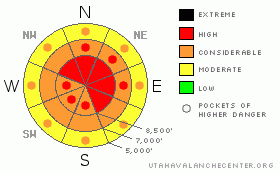
Danger Rose Tutorial
|
The avalanche danger will quickly rise to level 3 or Considerable on many slopes in the backcountry around Logan. You are likely to trigger wind slab avalanches in exposed terrain, and the danger of storm snow avalanches could rise rapidly on slopes that receive significant accumulations. Natural avalanches will become increasingly possible. Careful snowpack evaluation, cautious route finding, and conservative decision making are crucial.
Continued heavy snowfall and strong winds will likely cause the danger to rise to level 4, or HIGH overnight tonight. Natural avalanches may occur on many slopes... |
|
|
CURRENT CONDITIONS |

|
Expect rapidly rising avalanche danger and a winter storm, with strong winds and heavy snowfall today, tonight, and tomorrow.. The Ben Lomond Peak Snotel already reports 9/10ths of an inch of water in 4 or 5 inches of moist snow in the past few hours. The Tony Grove Snotel at 8400' reports 26 degrees and a couple inches so far, containing 3/10ths of an inch of water. There's 75 inches of total snow at the site containing just under 172% of average water for the date. Mt Ogden reports sustained 50-60 mph south winds overnight, with gusts in the 80s. |
|
|
THREAT #1 |

|
| WHERE |
PROBABILITY |
SIZE |
TREND |
|
|
|
|
| |
|
|
Over the next
24 hours.
|
|
|
Sustained and strong south winds overnight built wind slabs on the lee sides of ridge-tops and in exposed upper elevation terrain. It looks like strong winds will accompany heavy snowfall today and softer fresh wind slabs will likely form quite rapidly. Watch for and avoid stiffer drifted snow or potential wind slabs near ridge lines and in and around deposition prone terrain features like gullies, cliff-bands, and sub-ridges. You are likely to trigger wind slab avalanches a foot or two deep on drifted slopes approaching or steeper than about 35 degrees. Natural wind slab avalanches are possible in some areas. |
|
|
THREAT #2 |

|
| WHERE |
PROBABILITY |
SIZE |
TREND |

|
|
|
|
| |
|
|
Over the next
4 hours.
|
|
|
We've observed weak frost crystals or surface hoar, weak recrystallized or faceted snow near the surface, and weak and brittle crusts in the past few days. Looks like many areas will receive significant accumulations of heavy new snow, which may not stick well to the weak stuff that was yesterday's snow surface. |
|
|
MOUNTAIN WEATHER |

|
A powerful Pacific storm, fed by subtropical moisture and fueled by strong southwest winds is beginning to impact the region, and the National Weather Service has issued a Winter Storm Warning.... 10 t0 18 inches of accumulation is forecast for upper elevations in the Bear River Range by tomorrow morning. In addition, sustained 40 mph southwest winds and 60 mph gust are expected. The flow will shift around from the northwest later tonight and temperatures will drop... Areas that do better under a northwest flow will see continued heavy snowfall through much of tomorrow..... |
|
|
GENERAL ANNOUNCEMENTS |
We are offering a level 1 backcountry avalanche certification class with the USU Outdoor Recreation Program starting on Thursday, January 6... The class follows American Avalanche Association guidelines, and is overseen by AAA certified avalanche instructor and Utah Avalanche Center backcountry avalanche forecaster, Toby Weed. More Details
You can view a photo summary of last year's avalanche activity in the Logan Area HERE
I will be update this advisory in the mornings on Monday, Wednesday, Friday, and Saturday, and on other days if backcountry avalanche conditions warrant...
Send us your avalanche and snow observations. You can also call me at 435-757-7578, or email to uac@utahavalanchecenter.org
Donate to your favorite non-profit – The Friends of the Utah Avalanche Center. The UAC depends on contributions from users like you to support our work.
This advisory is from the U.S.D.A. Forest Service, which is solely responsible for its content. This advisory describes general avalanche conditions and local variations always occur. |
|
|
This information does not apply to developed ski areas or highways where avalanche control is normally done. This advisory is from the U.S.D.A. Forest Service, which is solely responsible for its content. This advisory describes general avalanche conditions and local variations always occur. |
|
This advisory provided by the USDA Forest Service, in partnership with:
The Friends of the Utah Avalanche Center, Utah Division of State Parks and Recreation, Utah Division of Emergency Management, Salt Lake County, Salt Lake Unified Fire Authority and the friends of the La Sal Avalanche Center. See our Sponsors Page for a complete list. |
