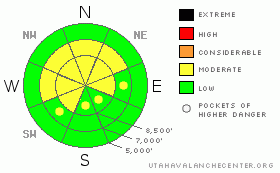
BOTTOM LINE
Danger by aspect and elevation on slopes approaching 35° or steeper.
(click HERE for tomorrow's danger rating)
|
Danger Rose Tutorial
|
There is a level 2 or Moderate danger, and heightened avalanche conditions exist on steep drifted slopes in the backcountry. In addition to possible wind slab avalanches, you might trigger dangerous cornice falls along exposed upper elevation ridge-lines or persistent slab avalanches, up to a couple feet deep, on isolated very steep slopes. There is a level 1 or Low danger on most slopes, especially in sheltered and lower elevation terrain. Use normal caution, but continue to practice safe travel protocols and evaluate the snow and terrain carefully..... |
|
|
CURRENT CONDITIONS |

|
On Boxing Day , you'll still probably be able to find nice powder riding conditions in the backcountry, though the best conditions are limited to sheltered shady areas. Temperatures will drop with the passage of a weak cold front and it'll be a chilly and breezy day in the mountains with a little bit of snowfall.
The Tony Grove Snotel at 8400' reports no new snow and 30 degrees. There's 74 inches of total snow at the site containing 181% of average water for the date. The 9700' Campbell Scientific weather station on Logan Peak is reporting sustained 30+ mph winds overnight from the south-southeast. The wind is more directly from the south this morning, and it's also 30 degrees. |
|
|
RECENT ACTIVITY |

|
Skiers intentionally triggered a nice wind slab on Thursday in upper Mill Hollow by dropping a cornice chunk on a drifted slope. The hard slab avalanche was reported to be around 1 foot deep and 75 feet wide, but it didn't run very far before breaking up in the trees below. I could see a couple fresh natural avalanches off the east side of Providence Peak.... They were below huge cornices and were likely triggered by cornice falls. There was a fairly widespread avalanche cycle across the region late last weekend, with evidence of large natural avalanches observed across the Bear River Range and in the Wellsville Mountain Wilderness.... |
|
|
THREAT #1 |

|
| WHERE |
PROBABILITY |
SIZE |
TREND |
|
|
|
|
| |
|
|
Over the next
24 hours.
|
|
|
Wind slabs built up under a sustained south-southeast wind, and some formed in somewhat unusual or unexpected places.....Watch for and avoid stiffer drifted snow or potential wind slabs near ridge lines and in and around deposition prone terrain features like gullies, cliff-bands, and sub-ridges. You might trigger wind slab avalanches 1 to 2 feet deep on drifted slopes of around 35 degrees or steeper..... |
|
|
THREAT #2 |

|
| WHERE |
PROBABILITY |
SIZE |
TREND |
|
|
|
|
| |
|
|
Over the next
24 hours.
|
|
|
I've found weak layers above and below the prominent rime-crust from earlier in the month... In most cases, these appear to have strengthened over the past few days, but I still don't really trust all steep slopes. Although becoming more unlikely, you still might trigger dangerous and destructive persistent or hard slab avalanches on some slopes steeper than about 38 degrees. These are most likely in very steep drifted upper elevation terrain and on rocky slopes or those with a shallow snowpack. |
|
|
THREAT #3 |

|
| WHERE |
PROBABILITY |
SIZE |
TREND |
|
|
|
|
| |
|
|
Over the next
24 hours.
|
|
|
Cornices built out and up in a big way in the last week. These could still be somewhat sensitive and are likely to break further back than you might expect. |
|
|
MOUNTAIN WEATHER |

|
A small disturbance will move through the region today, but it doesn't look very threatening. Temperatures will drop significantly today, winds will shift around from the west, and a little bit of snowfall can be expected. We're likely to pick up a couple inches of accumulation overnight tonight. A westerly flow will develop for the early part of the week, with periods of sunshine in the mountains and fog and cold air in the Valley. A strong Pacific storm will impact the region midweek, with sustained snow beginning Tuesday night or early Wednesday and a strong cold frontal passage Wednesday night, which could bring significant snowfall to the valley floors as well as the mountains... |
|
|
GENERAL ANNOUNCEMENTS |
You can view a photo summary of last year's avalanche activity in the Logan Area HERE
I will be update this advisory in the mornings on Monday, Wednesday, Friday, and Saturday, and on other days if backcountry avalanche conditions warrant...
Send us your avalanche and snow observations. You can also call me at 435-757-7578, or email to uac@utahavalanchecenter.org
Donate to your favorite non-profit – The Friends of the Utah Avalanche Center. The UAC depends on contributions from users like you to support our work.
This advisory is from the U.S.D.A. Forest Service, which is solely responsible for its content. This advisory describes general avalanche conditions and local variations always occur. |
|
|
This information does not apply to developed ski areas or highways where avalanche control is normally done. This advisory is from the U.S.D.A. Forest Service, which is solely responsible for its content. This advisory describes general avalanche conditions and local variations always occur. |
|
This advisory provided by the USDA Forest Service, in partnership with:
The Friends of the Utah Avalanche Center, Utah Division of State Parks and Recreation, Utah Division of Emergency Management, Salt Lake County, Salt Lake Unified Fire Authority and the friends of the La Sal Avalanche Center. See our Sponsors Page for a complete list. |
