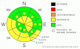
BOTTOM LINE
Danger by aspect and elevation on slopes approaching 35° or steeper.
(click HERE for tomorrow's danger rating)
|
Danger Rose Tutorial
|
This morning the danger is level 1 or Low on the majority of slopes in the region. But, there is a level 2 or Moderate danger, and heightened avalanche conditions still exist on some steep slopes in the backcountry. You might trigger dangerous cornice falls along exposed upper elevation ridge-lines or persistent slab avalanches, up to a couple feet deep, on isolated very steep slopes. And, the danger of loose wet avalanches will rise in areas where the surface snow becomes saturated due to solar warming. You'll want to avoid gullies or other potential terrain traps where wet snow might pile up. Use normal caution, continue to practice safe travel protocols, and evaluate the snow and terrain carefully..... |
|
|
CURRENT CONDITIONS |

|
Merry Christmas, you'll still probably be able to find nice powder riding conditions in the backcountry again today, with significantly more snow at upper elevations. The surface snow on sunny slopes is now crusty or moist, depending on the temperatures and sun angle. Shadier areas offer nice shallow re-crystallized powder at all but the lowest elevations. It'll be a nice day in the mountains, with balmy temperatures and periods of sunshine.
The Tony Grove Snotel at 8400' reports no new snow and 27 degrees. There's 76 inches of total snow at the site containing 185% of average water for the date. The 9400' Campbell Scientific weather station on Logan Peak is reading wind speeds again this morning, reporting 20 mph winds from the south-southeast, and it's 21 degrees. |
|
|
RECENT ACTIVITY |

|
I could see a couple fresh natural avalanches off the east side of Providence Peak.... They were below huge cornices and were likely triggered by cornice falls. There was a fairly widespread avalanche cycle across the region late last weekend, but despite fairly extensive recreational slope testing yesterday, we've received no recent reports of any triggered avalanches in the backcountry...... |
|
|
THREAT #1 |

|
| WHERE |
PROBABILITY |
SIZE |
TREND |

|
|
|
|
| |
|
|
Over the next
24 hours.
|
|
|
Cornices built out and up in a big way in the last week. These could still be somewhat sensitive and are likely to break further back than you might expect. Warming temperatures today will cause these monsters to sag and some to perhaps calve off large chunks.... |
|
|
THREAT #2 |

|
| WHERE |
PROBABILITY |
SIZE |
TREND |

|
|
|
|
| |
|
|
Over the next
24 hours.
|
|
|
I've found weak layers above and below the prominent rime-crust from earlier in the month... In most cases, these appear to have strengthened over the past few days, but I still don't just blindly trust all steep slopes. Although becoming more unlikely, you still might trigger dangerous and destructive persistent or hard slab avalanches on slopes steeper than about 38 degrees. These are most likely in very steep, previously drifted upper elevation terrain and on rocky slopes or those with a shallow snowpack. |
|
|
THREAT #3 |

|
| WHERE |
PROBABILITY |
SIZE |
TREND |

|
|
|
|
| |
|
|
Over the next
12 hours.
|
|
|
Solar warming could cause a danger of loose wet avalanches on steep slopes with saturated snow. You'll want to avoid sun-warmed avalanche paths, steep slopes, and especially gullies or other terrain traps where wet snow might pile up deeply when things warm up....... |
|
|
MOUNTAIN WEATHER |

|
Fair weather and warmer temperatures in store for the mountains again today. The ridge will move off to the east and a small disturbance will move through the region on Sunday, but it doesn't look very threatening. A westerly flow will develop for early next week with a chance for some snow showers, and a more potent and colder Pacific weather system is on the way for the middle of next week..... |
|
|
GENERAL ANNOUNCEMENTS |
You can view a photo summary of last year's avalanche activity in the Logan Area HERE
I will be update this advisory in the mornings on Monday, Wednesday, Friday, and Saturday, and on other days if backcountry avalanche conditions warrant...
Send us your avalanche and snow observations. You can also call me at 435-757-7578, or email to uac@utahavalanchecenter.org
Donate to your favorite non-profit – The Friends of the Utah Avalanche Center. The UAC depends on contributions from users like you to support our work.
This advisory is from the U.S.D.A. Forest Service, which is solely responsible for its content. This advisory describes general avalanche conditions and local variations always occur. |
|
|
This information does not apply to developed ski areas or highways where avalanche control is normally done. This advisory is from the U.S.D.A. Forest Service, which is solely responsible for its content. This advisory describes general avalanche conditions and local variations always occur. |
|
This advisory provided by the USDA Forest Service, in partnership with:
The Friends of the Utah Avalanche Center, Utah Division of State Parks and Recreation, Utah Division of Emergency Management, Salt Lake County, Salt Lake Unified Fire Authority and the friends of the La Sal Avalanche Center. See our Sponsors Page for a complete list. |
