BOTTOM LINE
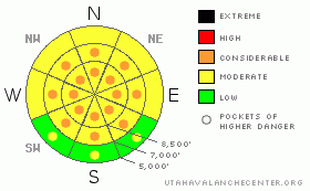
Danger by aspect and elevation on slopes approaching 35° or steeper.
(click HERE for tomorrow's danger rating)
|
Danger Rose Tutorial
|
Snow and winds will cause a rising danger in the backcountry today. Currently there is a level 2 or Moderate danger, and heightened avalanche conditions exist in most areas. Triggered storm snow, wind slab, and persistent slab avalanches are possible on slopes approaching or steeper than about 35 degrees. There are also pockets with a level 3 or Considerable danger in drifted terrain at upper and mid-elevations, where large avalanches are possible and dangerous avalanche conditions exist. Careful snowpack evaluation, cautious route finding, and conservative decision making are crucial in the backcountry today. |
|
|
CURRENT CONDITIONS |

|
The Tony Grove Snotel at 8400' reports only a couple inches of new snow, containing 2/10ths of an inch of water in the last 24 hours. There's 77 inches of total snow at the site containing 192% of average water for the date. The wind sensor at the CSI weather station on Logan Peak is rimed, and it's not reading wind speeds again this morning, but it's 23 degrees at 9400'. Mt. Ogden reports light to moderate south winds this morning..... |
|
|
RECENT ACTIVITY |

|
With yesterday's clearing, we could see evidence of a fairly widespread natural cycle from Sunday night in the Central Bear River Range, and fairly large naturals ran overnight Sunday night on the east side of the Wellsville Range above the town of Mendon. I did not get any observations from the backcountry yesterday... |
|
|
THREAT #1 |

|
| WHERE |
PROBABILITY |
SIZE |
TREND |

|
|
|
|
| |
|
|
Over the next
24 hours.
|
|
|
A few inches of heavy snow may accumulate on the lighter density powder from the last couple days and storm snow avalanches will become possible. More than expected snowfall and winds will cause the danger to rise still further and it could become likely that you would trigger avalanches on steep slopes....
Rain at lower and lower mid-elevations may saturate the shallow snowpack and cause a danger of wet avalanches on steep slopes.. If the snow you're on gets wet you should avoid steep slopes and be wary of steep-sided gullies or other terrain traps where wet snow could pile up deeply.... |
|
|
THREAT #2 |

|
| WHERE |
PROBABILITY |
SIZE |
TREND |

|
|
|
|
| |
|
|
Over the next
24 hours.
|
|
|
There's plenty of soft snow along the ridge-lines that increasing southwest winds could drift into avalanche starting zones and as the new snow falls it'll be deposited more deeply on the lee side of ridges as well. Watch for and avoid stiffer drifted snow or potential wind slabs near ridge lines and in and around deposition prone terrain features like gullies, cliff-bands, and sub-ridges. You might trigger fresh or older wind slab avalanches 1 to 4 feet deep on drifted slopes approaching 35 degrees or steeper..... |
|
|
THREAT #3 |

|
| WHERE |
PROBABILITY |
SIZE |
TREND |

|
|
|
|
| |
|
|
Over the next
24 hours.
|
|
|
Cold temperatures weakened the surface snow late last week, and heavy accumulations of new snow and sustained southwest winds built a substantial slab layer, especially at upper elevations. Additional loading today could reactivate buried weak layers on some slopes. Avalanches running on persistent weak layers could be triggered remotely from a distance, or worse from below! |
|
|
MOUNTAIN WEATHER |

|
Expect moist snow in the mountains, with rain possibly developing in the valleys today.. The National Weather Service forecasts 2 to 4 inches of dense snow accumulation in the Central Bear River Range today, but more is possible in this moist pineapple-smelling flow.... Another inch or two is likely tonight, with more showery conditions with gradual clearing tomorrow. It looks fairly nice heading into Christmas, with sunny conditions forecast for Friday...... |
|
|
GENERAL ANNOUNCEMENTS |
You can view a photo summary of last year's avalanche activity in the Logan Area HERE
Send us your avalanche and snow observations. You can also call me at 435-757-7578, or email to uac@utahavalanchecenter.org
Donate to your favorite non-profit – The Friends of the Utah Avalanche Center. The UAC depends on contributions from users like you to support our work.
This advisory is from the U.S.D.A. Forest Service, which is solely responsible for its content. This advisory describes general avalanche conditions and local variations always occur. |
|
|
This information does not apply to developed ski areas or highways where avalanche control is normally done. This advisory is from the U.S.D.A. Forest Service, which is solely responsible for its content. This advisory describes general avalanche conditions and local variations always occur. |
|
This advisory provided by the USDA Forest Service, in partnership with:
The Friends of the Utah Avalanche Center, Utah Division of State Parks and Recreation, Utah Division of Emergency Management, Salt Lake County, Salt Lake Unified Fire Authority and the friends of the La Sal Avalanche Center. See our Sponsors Page for a complete list. |
