AVALANCHE WARNING »
Dangerous avalanche conditions are occuring or are imminent.
Backcountry travel in avalanche terrain is not recommended.
|
 |
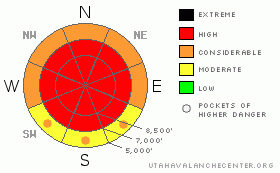
Notice: We've issued an Avalanche Warning for all the Utah Mountains. A High (level 4) avalanche danger exists in all the mountains of Utah with an Extreme (or level 5) danger in the Provo Area Mountains. Backcountry travelers should avoid all avalanche terrain and stay out from under steep slopes. This warning does not include ski areas or highways where avalanche control is normally done....... |
|
|
BOTTOM LINE
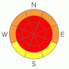
Danger by aspect and elevation on slopes approaching 35° or steeper.
(click HERE for tomorrow's danger rating)
|
Danger Rose Tutorial
|
The danger in the backcountry has risen to level 4 or HIGH and very dangerous avalanche conditions exist. Natural and triggered avalanches are likely. You should avoid travel in avalanche terrain today. Stay out from under steep slopes and well clear of obvious or historic avalanche paths. |
|
|
CURRENT CONDITIONS |

|
Heavy snowfall, strong winds, and rain yesterday certainly upped the anti and created very dangerous avalanche conditions on many slopes.
The Tony Grove Snotel at 8400' reports a couple feet of new snow, containing 3.5 inches of water in the last 48 hours. There's 81 inches of total snow at the site containing close to 200% of average water for the date. The CSI weather station on Logan Peak reported sustained 20-25 mph southwest winds with gusts in the 60s yesterday and shifting from west to northwest overnight.... But the wind sensor looks like it was hit by more rime overnight, and it's not reading wind speeds this morning. It's 15 degrees at 9400'. |
|
|
RECENT ACTIVITY |

|
We've received numerous reports of avalanches and sensitive or "touchy" snow conditions across the region from yesterday. Details are limited from the event, but it appears two backcountry skiers were caught and carried in an avalanche in the Central Wasatch. One was fully buried with a broken leg, and was still able to ski out with the assistance of his companions. A large natural cycle occurred yesterday in the Provo Area Mountains, and other sizable natural and triggered avalanches have been reported from across the region.
Locally; I remote triggered a soft slab avalanche during the onset of the storm on Saturday, and it appears the plows triggered a small avalanche off highway 89, across from the Beaver Backside parking area... Otherwise, I did not get any observations from the backcountry yesterday... |
|
|
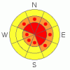
THREAT #1 |

|
| WHERE |
PROBABILITY |
SIZE |
TREND |
|
|
|
|
| |
|
|
Over the next
24 hours.
|
|
|
Cold temperatures weakened the surface snow late last week, and rapid accumulations of heavy new snow and sustained west winds over the weekend have created a high avalanche danger on many slopes in the area. Dangerous natural and triggered avalanches are now likely to occur. Avalanches can be triggered remotely from a distance, or worse from below! |
|
|
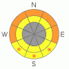
THREAT #2 |

|
| WHERE |
PROBABILITY |
SIZE |
TREND |
|
|
|
|
| |
|
|
Over the next
24 hours.
|
|
|
Overnight west winds again sustained hourly average wind-speeds in the 20-25 mph range, which is plenty strong enough to drift the fresh snow into wind slabs on top of the weak surface layers formed by last week's cold temperatures. Watch for and avoid stiffer drifted snow or potential wind slabs near ridge lines and in and around deposition prone terrain features like gullies, cliff-bands, and sub-ridges. You are likely to trigger wind slab avalanches 2 to 4 feet deep on freshly drifted slopes approaching 35 degrees or steeper. |
|
|
THREAT #3 |

|
| WHERE |
PROBABILITY |
SIZE |
TREND |
|
|
|
|
| |
|
|
Over the next
24
hours.
|
|
|
Heavy rain saturated lower elevation slopes, and triggered wet avalanches are likely on steep slopes with saturated snow. Stay clear of gullies and other terrain traps where snow might pile up deeply. |
|
|
MOUNTAIN WEATHER |

|
The cold front has moved into Central Utah this morning, where it will stall today. We'll continue to see some snowfall in the mountains, with another 3 to 5 inches possible. But, it'll be a bit of a break from the heavy accumulations in the past couple days. The southwest flow, tapped into moist Pacific air and snowfall, heavy at times will resume tomorrow and likely continue into at least Thursday.... |
|
|
GENERAL ANNOUNCEMENTS |
You can view a photo summary of last year's avalanche activity in the Logan Area HERE
Send us your avalanche and snow observations. You can also call me at 435-757-7578, or email to uac@utahavalanchecenter.org
Donate to your favorite non-profit – The Friends of the Utah Avalanche Center. The UAC depends on contributions from users like you to support our work.
This advisory is from the U.S.D.A. Forest Service, which is solely responsible for its content. This advisory describes general avalanche conditions and local variations always occur. |
|
|
This information does not apply to developed ski areas or highways where avalanche control is normally done. This advisory is from the U.S.D.A. Forest Service, which is solely responsible for its content. This advisory describes general avalanche conditions and local variations always occur. |
|
This advisory provided by the USDA Forest Service, in partnership with:
The Friends of the Utah Avalanche Center, Utah Division of State Parks and Recreation, Utah Division of Emergency Management, Salt Lake County, Salt Lake Unified Fire Authority and the friends of the La Sal Avalanche Center. See our Sponsors Page for a complete list. |
