AVALANCHE WARNING »
Dangerous avalanche conditions are occuring or are imminent.
Backcountry travel in avalanche terrain is not recommended.
|
 |
Notice: THIS AVALANCHE WARNING IS FOR ALL THE MOUNTAINS OF NORTHERN...CENTRAL AND SOUTHERN UTAH. A HIGH DANGER EXISTS THIS MORNING IN THE PROVO AND OGDEN AREA MOUNTAINS. WITH CONTINUING HEAVY SNOW AND STRONG WINDS THE AVALANCHE DANGER WILL INCREASE TO HIGH OVERNIGHT TONIGHT IN THE REMAINING MOUNTAIN AREAS OF NORTHERN...CENTRAL AND SOUTHERN UTAH. BACK COUNTRY TRAVELERS SHOULD AVOID TRAVEL ON AND BELOW STEEP SLOPES. THIS WARNING DOES NOT INCLUDE SKI AREAS OR HIGHWAYS WHERE AVALANCHE CONTROL IS NORMALLY DONE. |
|
|
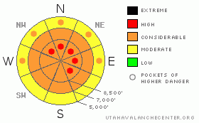
BOTTOM LINE
Danger by aspect and elevation on slopes approaching 35° or steeper.
(click HERE for tomorrow's danger rating)
|
Danger Rose Tutorial
|
A winter storm with increasing winds, prolonged heavy and wet snowfall, and rain at lower elevations has created dangerous avalanche conditions and a level 3 or Considerable danger in the backcountry today. Triggered storm snow and wind slab avalanches are likely in many areas on slopes approaching 35 degrees in steepness, and some natural avalanches may also occur. Rain at lower elevations will cause a danger of wet avalanches on steep slopes with saturated snow. Careful snowpack evaluation, cautious route finding, and conservative decision making are crucial.
Continued heavy snowfall and strong winds will likely cause the danger to rise to level 4, (HIGH) overnight tonight. Natural avalanches may occur on many slopes... |
|
|
CURRENT CONDITIONS |

|
This weekend's winter storm will continue to increase the avalanche danger in the backcountry. The cold temperatures that kept the snow nice last week also created weak surface layers above a widespread and slick rain or rime-crust. Heavy snowfall yesterday certainly upped the anti and created dangerous avalanche conditions on many slopes.
The Tony Grove Snotel at 8400' reports several inches of new snow, containing 1.4 inches of water in the last 24 hours. There's 71 inches of total snow at the site containing 182% of average water for the date. The CSI weather station on Logan Peak reports sustained 15-25 mph winds with gusts in the 40s overnight from the southwest, but the wind sensor looks like it was hit by some rime this morning. It's 25 degrees at 9400'. |
|
|
RECENT ACTIVITY |

|
We've received numerous reports of avalanches and sensitive or "touchy" snow conditions across the region from yesterday. With more heavy snow accumulation and increasingly strong southwest winds forecast, we expect more dangerous avalanche conditions today.
We remote triggered a soft slab avalanche from around 50 feet away early yesterday afternoon. The avalanche on a east facing slope at around 9000' was a foot or so deep and around 50 feet wide. After all the cracking we had been triggering, we were not really surprised, but the soft avalanche ran a bit further and faster and piled up a little deeper than we expected.... |
|
|
THREAT #1 |

|
| WHERE |
PROBABILITY |
SIZE |
TREND |

|
|
|
|
| |
|
|
Over the next
24 hours.
|
|
|
Cold temperatures weakened the surface snow late last week, and with rapid accumulations of heavy new snow and increasing southwest winds forecast to continue through the weekend, we expect conditions to develop where larger and much more dangerous avalanches will occur.
As the snow accumulates this weekend, we are seeing widespread easily and remote triggered soft slabs. We expect these to become large and less manageable as more heavy snow accumulates.... Natural avalanches will probably occur on many slopes as soon as enough weight builds up to tip the balance, which might well be overnight tonight.... |
|
|
THREAT #2 |

|
| WHERE |
PROBABILITY |
SIZE |
TREND |
|
|
|
|
| |
|
|
Over the next
24 hours.
|
|
|
Overnight southwest winds sustained hourly average wind-speeds in the 15-25 mph range, which is plenty strong enough to drift the fresh snow into wind slabs on top of the weak surface layers formed by last week's cold temperatures. Expect significantly increasing southwest winds today and especially overnight tonight... Watch for stiffer drifted snow or potential wind slabs near ridge lines and in and around deposition prone terrain features like gullies, cliff-bands, and sub-ridges. You are likely to trigger wind slab avalanches 1 to 3 feet deep on freshly drifted slopes approaching 35 degrees or steeper. |
|
|
THREAT #3 |

|
| WHERE |
PROBABILITY |
SIZE |
TREND |

|
|
|
|
| |
|
|
Over the next
12 hours.
|
|
|
Rain today will likely saturate the lower and perhaps mid-elevation snow, increasing the danger of wet avalanches on steep slopes.... |
|
|
MOUNTAIN WEATHER |

|
The National Weather Service has issued a Winter Storm Warning for the mountains of Northern Utah and southern Idaho through Monday afternoon. A moist flow from the southwest will bring a prolonged period of snow through the weekend. The rain/snow line will rise to around 7000' feet today. A strong cold front will impact the area overnight tonight dropping the snow line back down to the valley floor. Heavy snowfall and strong winds are expected... We'll see a bit of a break tomorrow before the moist Pacific flow continues well into to coming holiday week, with still more snow on the way..... |
|
|
GENERAL ANNOUNCEMENTS |
You can view a photo summary of last year's avalanche activity in the Logan Area HERE
Send us your avalanche and snow observations. You can also call me at 435-757-7578, or email to uac@utahavalanchecenter.org
Donate to your favorite non-profit – The Friends of the Utah Avalanche Center. The UAC depends on contributions from users like you to support our work.
This advisory is from the U.S.D.A. Forest Service, which is solely responsible for its content. This advisory describes general avalanche conditions and local variations always occur. |
|
|
This information does not apply to developed ski areas or highways where avalanche control is normally done. This advisory is from the U.S.D.A. Forest Service, which is solely responsible for its content. This advisory describes general avalanche conditions and local variations always occur. |
|
This advisory provided by the USDA Forest Service, in partnership with:
The Friends of the Utah Avalanche Center, Utah Division of State Parks and Recreation, Utah Division of Emergency Management, Salt Lake County, Salt Lake Unified Fire Authority and the friends of the La Sal Avalanche Center. See our Sponsors Page for a complete list. |
