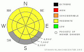
BOTTOM LINE
Danger by aspect and elevation on slopes approaching 35° or steeper.
(click HERE for tomorrow's danger rating)
|
Danger Rose Tutorial
|
There is a level 2 or Moderate avalanche danger in the backcountry around Logan, wet avalanches are possible and heightened avalanche conditions exist on steep slopes with saturated snow. Evaluate the snow and terrain carefully and watch for an increasing danger of wet avalanches due to warming or solar heating. |
|
|
CURRENT CONDITIONS |

|
Rain fell even at the highest elevations yesterday morning and a nasty creme brulee ice crust developed along exposed ridges and in terrain above around 8300' in elevation. Sticky mashed potatoes describes yesterday's saturated snow at mid and lower elevations....
There's five feet of total snow at the Tony Grove Snotel, containing 182% of average water for the date. Its already 35 degrees up at 8400' at 6:00 this morning. Expect another fairly warm day in the mountains.... |
|
|
RECENT ACTIVITY |

|
No avalanches were reported from a busy weekend in the mountains. I noticed many large roller balls and a few loose sluffs yesterday in Logan Canyon. Only time will tell, but we'll have to watch our new widespread rain-rime ice-crust carefully. Weak sugary snow or faceted layers often form near such features in time. |
|
|
THREAT #1 |

|
| WHERE |
PROBABILITY |
SIZE |
TREND |

|
|
|
|
| |
|
|
Over the next
10 hours.
|
|
|
Rain and unseasonably warm weather saturated the top few inches of snow up high and the entire shallow remaining snowpack down lower. Until we get a nice solid freeze, the fresh snow from Friday will stay saturated and prone to wet avalanching... The warmer it gets, the more active the snow will become. Roller balls and fresh loose sluffs indicate the potential for more wet activity. Sheltered sunny slopes and bowls facing the sun and reflecting inward like solar ovens will heat up quickly. Increased creep and glide rates or slab softening could cause a danger of slab type releases.
Avoid steep slopes with moist or saturated surface snow and be extra cautious around potential terrain traps like trees or steep sided gullies... |
|
|
THREAT #2 |

|
| WHERE |
PROBABILITY |
SIZE |
TREND |
|
|
|
|
| |
|
|
Over the next
10 hours.
|
|
|
Warming temperatures will cause cornices to sag and some to calve off. Large softened cornices could be triggered and may break farther back than expected. Cornice failures may trigger slab or wet avalanches on slopes below.. |
|
|
MOUNTAIN WEATHER |

|
Expect another warm day in the mountains, with high temperatures in the mid thirties at 9000'..Southwest winds will again increase tomorrow, ahead of the next wave of Pacific storminess, which will bring accumulating snowfall to the mountains mainly Tuesday night.. 6 inches to a foot may fall at higher elevations. Expect cooling with the front and rain will switch over to snow in the valleys by Wednesday morning. Mostly cloudy and showery weather will continue through the remainder of the week, with the next Pacific disturbance scheduled for the Saturday- Saturday night time-frame... |
|
|
GENERAL ANNOUNCEMENTS |
You can view a photo summary of last year's avalanche activity in the Logan Area HERE
Send us your avalanche and snow observations. You can also call me at 435-757-7578, or email to uac@utahavalanchecenter.org
Donate to your favorite non-profit – The Friends of the Utah Avalanche Center. The UAC depends on contributions from users like you to support our work.
This advisory is from the U.S.D.A. Forest Service, which is solely responsible for its content. This advisory describes general avalanche conditions and local variations always occur. |
|
|
This information does not apply to developed ski areas or highways where avalanche control is normally done. This advisory is from the U.S.D.A. Forest Service, which is solely responsible for its content. This advisory describes general avalanche conditions and local variations always occur. |
|
This advisory provided by the USDA Forest Service, in partnership with:
The Friends of the Utah Avalanche Center, Utah Division of State Parks and Recreation, Utah Division of Emergency Management, Salt Lake County, Salt Lake Unified Fire Authority and the friends of the La Sal Avalanche Center. See our Sponsors Page for a complete list. |
