BOTTOM LINE
Danger by aspect and elevation on slopes approaching 35° or steeper.
(click HERE for tomorrow's danger rating)
|
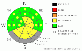
Danger Rose Tutorial
|
There is a level 2 or Moderate avalanche danger in the backcountry around Logan, triggered avalanches are possible and heightened avalanche conditions exist on drifted upper and mid elevation elevation slopes. Warming temperatures will also cause a heightened danger of wet avalanches on steep slopes with saturated surface snow. Evaluate the snow and terrain carefully in drifted terrain and watch for an increasing danger of wet avalanches due to warming or solar heating... |
|
|
CURRENT CONDITIONS |

|
The Tony Grove Snotel reports another good shot of snow Friday and a few more inches overnight, with 1.9 inches of water in the last 48 hours. There's 62 inches of total snow at the site, containing 187% of average water for the date. The Campbell Scientific Logan Peak weather station at 9700' is reporting northwest winds in the teens and rapidly rising temperatures. Currently reading 28 degrees, and with return to high pressure conditions and a bit of sunshine likely, expect a fairly warm day in the mountains.... |
|
|
RECENT ACTIVITY |

|
Riders report triggering multiple small soft slab avalanches in the Tony Grove Area on Friday... The manageable new snow avalanches were failing on the older snow interface or within the new snow and were less than a foot deep and around 20 feet wide...
An observer yesterday noticed evidence of a fair amount natural avalanche activity in the Wellsville Mountain Wilderness above Mendon, which occurred with Friday's quick and windy storm. From a distance it looked as though only new snow was involved. |
|
|
THREAT #1 |

|
| WHERE |
PROBABILITY |
SIZE |
TREND |
|
|
|
|
| |
|
|
Over the next
24 hours.
|
|
|
Strong west winds and heavy snowfall built wind slabs in lee terrain on Friday, and northwest wind picked up again last night. After initial instability within the new snow or a poor bound with the older snow surface, the wind slabs appear to have bounded fairly well, and no avalanches were reported yesterday. However, you still might trigger wind slabs in the 1-2 foot deep range, and stiffer more stubborn slabs are perhaps less manageable. Be on the lookout for stiffer, rounded wind deposits in exposed upper elevation terrain and in and around terrain features like gullies, sub-ridges, scoops, and cliff bands. It's good practice to avoid steep drifted slopes with trees or other terrain traps below.
Large cornices may break farther back than expected. Cornice failures may trigger wind slab avalanches on slopes below.... |
|
|
THREAT #2 |

|
| WHERE |
PROBABILITY |
SIZE |
TREND |

|
|
|
|
| |
|
|
Over the next
24
hours.
|
|
|
With rapidly rising temperatures today, the fresh snow from Friday will get saturated and prone to wet avalanching... Roller balls and fresh loose sluffs indicate the potential for more activity. Avoid steep slopes with moist or saturated surface snow and be extra cautious around potential terrain traps like trees or steep sided gullies..... Sheltered sunny slopes and bowls facing the sun and reflecting inward like solar ovens will be the most suspect areas. |
|
|
MOUNTAIN WEATHER |

|
We'll see a few lingering clouds and showers and gradually decreasing west winds as a strong high pressure will bring warming temperatures and a bit of sunshine to the mountains today....We'll see a warm and breezy night tonight with low temperatures hovering around freezing, with even warmer partly sunny conditions for tomorrow...High temperatures in the mountains will be near 40 degrees. Southwest winds will again increase on Monday night ahead of the next wave of Pacific storminess, which will bring accumulating snowfall to the mountains on Tuesday and Tuesday night...... |
|
|
GENERAL ANNOUNCEMENTS |
You can view a photo summary of last year's avalanche activity in the Logan Area HERE
Send us your avalanche and snow observations. You can also call me at 435-757-7578, or email to uac@utahavalanchecenter.org
Donate to your favorite non-profit – The Friends of the Utah Avalanche Center. The UAC depends on contributions from users like you to support our work.
This advisory is from the U.S.D.A. Forest Service, which is solely responsible for its content. This advisory describes general avalanche conditions and local variations always occur. |
|
|
This information does not apply to developed ski areas or highways where avalanche control is normally done. This advisory is from the U.S.D.A. Forest Service, which is solely responsible for its content. This advisory describes general avalanche conditions and local variations always occur. |
|
This advisory provided by the USDA Forest Service, in partnership with:
The Friends of the Utah Avalanche Center, Utah Division of State Parks and Recreation, Utah Division of Emergency Management, Salt Lake County, Salt Lake Unified Fire Authority and the friends of the La Sal Avalanche Center. See our Sponsors Page for a complete list. |
