BOTTOM LINE
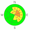
Danger by aspect and elevation on slopes approaching 35° or steeper.
(click HERE for tomorrow's danger rating)
|

Danger Rose Tutorial
|
There is a level 2 or Moderate avalanche danger in the backcountry, and heightened avalanche conditions exist on drifted upper and mid elevation elevation slopes. You could trigger wind slab avalanches on slopes steeper than about 35 degrees. There are also slopes with a Level 3, or Considerable danger in exposed terrain at upper elevations, and dangerous avalanche conditions exist. Evaluate the snow and terrain carefully, and use cautious route finding and conservative decision making in drifted terrain... You'll find safer conditions and a level 1 danger at lower elevations and in sheltered terrain. |
|
|
CURRENT CONDITIONS |

|
We're finding fine powder riding conditions in the Bear River Range, with good snow coverage for this time of year, especially up high.
The Tony Grove Snotel reports another good shot of snow yesterday, with 1.6 inches of water in the last 24 hours. There's 63 inches of total snow at the site, containing 189% of average water for the date. The Campbell Scientific Logan Peak weather station at 9700' is reporting 15 degrees and only light northwest winds this morning. But, west winds are forecast to pick up significantly again today and peak tonight. |
|
|
RECENT ACTIVITY |

|
Riders report triggering multiple small soft slab avalanches in the Tony Grove Area yesterday... The manageable new snow avalanches were failing on the older snow interface or within the new snow and were less than a foot deep and around 20 feet wide... |
|
|
THREAT #1 |

|
| WHERE |
PROBABILITY |
SIZE |
TREND |

|
|
|
|
| |
|
|
Over the next
24 hours.
|
|
|
Strong west winds and heavy snowfall built wind slabs in lee terrain yesterday, and the wind and snowfall will resume today, further enhancing the threat. Avalanches today could be a bit more stubborn and perhaps less manageable. Freshly formed wind slabs, 1-3 feet deep, could be sensitive to human triggering. Be on the lookout for building wind deposits in exposed upper elevation terrain and in and around terrain features like gullies, sub-ridges, scoops, and cliff bands. Cracking and collapsing are bad signs, indicating instability. Avoid steep drifted slopes with trees or other terrain traps below. |
|
|
THREAT #2 |

|
| WHERE |
PROBABILITY |
SIZE |
TREND |
|
|
|
|
| |
|
|
Over the next
24
hours.
|
|
|
Large cornices may break farther back than expected. Cornice failures may trigger wind slab avalanches on slopes below.... |
|
|
MOUNTAIN WEATHER |

|
Expect increasing west wind and snowfall developing again this afternoon and intensifying overnight. Another 6" to a foot of accumulation is forecast, with sustained 45-50 mph winds and gusts nearing 75 mph overnight. A strong high pressure will build into the region tomorrow, but will only last a couple days, with the next Pacific storm scheduled for Tuesday afternoon. |
|
|
GENERAL ANNOUNCEMENTS |
You can view a photo summary of last year's avalanche activity in the Logan Area HERE
Send us your avalanche and snow observations. You can also call me at 435-757-7578, or email to uac@utahavalanchecenter.org
Donate to your favorite non-profit – The Friends of the Utah Avalanche Center. The UAC depends on contributions from users like you to support our work.
This advisory is from the U.S.D.A. Forest Service, which is solely responsible for its content. This advisory describes general avalanche conditions and local variations always occur. |
|
|
This information does not apply to developed ski areas or highways where avalanche control is normally done. This advisory is from the U.S.D.A. Forest Service, which is solely responsible for its content. This advisory describes general avalanche conditions and local variations always occur. |
|
This advisory provided by the USDA Forest Service, in partnership with:
The Friends of the Utah Avalanche Center, Utah Division of State Parks and Recreation, Utah Division of Emergency Management, Salt Lake County, Salt Lake Unified Fire Authority and the friends of the La Sal Avalanche Center. See our Sponsors Page for a complete list. |
