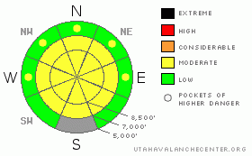
BOTTOM LINE
Danger by aspect and elevation on slopes approaching 35° or steeper.
(click HERE for tomorrow's danger rating)
|
Danger Rose Tutorial
|
Expect a rising level 2 or Moderate avalanche danger in the backcountry today, with strong west winds and periods of heavy snow.. Heightened avalanche conditions exist and will likely become more widespread on drifted upper and mid-elevation slopes. You might trigger wind slab avalanches on slopes steeper than about 35 degrees. Evaluate the snow and terrain carefully, especially in areas with drifted snow... |
|
|
CURRENT CONDITIONS |

|
You'll find full-on weather in the mountains today, with increasingly strong west winds and periods of heavy snowfall.... We're finding fine powder riding conditions in the Bear River Range, with good snow coverage for this time of year, especially up high. The Tony Grove Snotel reports another 3 inches of snow with 3/10ths of an inch of water in the last 24 hours. There's 57 inches of total snow at the site, containing 177% of average water for the date. The Campbell Scientific Logan Peak weather station at 9700' is reporting 17 degrees and increasing west-southwest winds this morning, with almost 30 mph average windspeeds and a recent 53 mph gust. |
|
|
RECENT ACTIVITY |

|
I haven't received reports of any recent avalanches in the mountains around Logan.... |
|
|
THREAT #1 |

|
| WHERE |
PROBABILITY |
SIZE |
TREND |
|
|
|
|
| |
|
|
Over the next
24 hours.
|
|
|
Strong west winds and periods of heavy snowfall will rapidly build wind slabs in lee terrain today. Freshly formed wind slabs, 1-2 feet deep, could be sensitive to human triggering. Be on the lookout for building wind deposits in exposed upper elevation terrain and in and around terrain features like gullies, sub-ridges, scoops, and cliff bands. Cracking and collapsing are bad signs, indicating instability. Avoid steep drifted slopes with trees or other terrain traps below. |
|
|
MOUNTAIN WEATHER |

|
The National Weather Service in Salt Lake City issued a Winter Weather Advisory for the mountains of Northern Utah. Expect strong westerly wind and periods of heavy snowfall today, with 6 to 12 inches of accumulation possible. Storminess should tapper to showers tonight. Another wave of moist Pacific weather will bring additional snow starting around Saturday afternoon. A high pressure system will develop for early next week.... |
|
|
GENERAL ANNOUNCEMENTS |
You can view a photo summary of last year's avalanche activity in the Logan Area HERE
Send us your avalanche and snow observations. You can also call me at 435-757-7578, or email to uac@utahavalanchecenter.org
Donate to your favorite non-profit – The Friends of the Utah Avalanche Center. The UAC depends on contributions from users like you to support our work.
This advisory is from the U.S.D.A. Forest Service, which is solely responsible for its content. This advisory describes general avalanche conditions and local variations always occur. |
|
|
This information does not apply to developed ski areas or highways where avalanche control is normally done. This advisory is from the U.S.D.A. Forest Service, which is solely responsible for its content. This advisory describes general avalanche conditions and local variations always occur. |
|
This advisory provided by the USDA Forest Service, in partnership with:
The Friends of the Utah Avalanche Center, Utah Division of State Parks and Recreation, Utah Division of Emergency Management, Salt Lake County, Salt Lake Unified Fire Authority and the friends of the La Sal Avalanche Center. See our Sponsors Page for a complete list. |
