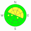
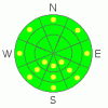
BOTTOM LINE
Danger by aspect and elevation on slopes approaching 35° or steeper.
(click HERE for tomorrow's danger rating)
|
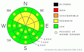
Danger Rose Tutorial
|
There is a level 2 or Moderate avalanche danger in the backcountry, and you could trigger wind slab avalanches on drifted upper and mid-elevation slopes steeper than about 35 degrees. Mild mountain temperatures or periods of sunshine could cause a chance of loose wet avalanches on steep slopes with saturated surface snow. There is a level 1 or Low danger on the majority of slopes in the region, especially in sheltered terrain... Use normal caution, but evaluate the snow and terrain carefully, especially in areas with drifted snow... |
|
|
CURRENT CONDITIONS |

|
Despite yesterday's sunshine and warmish temperatures, and increasing southwest wind this morning, you'll still find nice powder riding conditions and good coverage at upper and mid elevations especially in the Central Bear River Range. Lower elevations saw a bit of a melt-down with last week's rain, and there's not much snow left on sunny slopes or at many of the lower trailheads.
The Tony Grove Snotel reported a good dump Monday and Monday night, with well over a foot of new snow with 1.6 inches of water equivalent. There's 57 inches of total snow at the site, containing 180% of average water for the date. The Campbell Scientific Logan Peak weather station is reporting increasing southwest winds overnight and this morning after fairly calm readings yesterday. Southwest winds pumped out almost 30 mph average windspeeds in the last couple hours, and it's a toasty 27 degrees at 9700' on Logan Peak... |
|
|
RECENT ACTIVITY |

|
Despite receiving less snow than the Bear River Range, ski resorts in the Wasatch Range reported some active fresh wind slabs from control work yesterday. I haven't received reports of any recent avalanches in the local backcountry. |
|
|
THREAT #1 |

|
| WHERE |
PROBABILITY |
SIZE |
TREND |
|
|
|
|
| |
|
|
Over the next
24 hours.
|
|
|
Soft, freshly formed wind slabs 1-2 feet deep could be sensitive to human triggering. Be on the lookout for recent wind deposits in exposed upper elevation terrain and in and around terrain features like gullies, sub-ridges, scoops, and cliff bands. Wind slabs consist of stiffer drifted snow, have a rounded and chalky appearance, and can sound hollow or drum-like...
Fresh snow may be hiding wind slabs , so you'll have to poke around in the snow and investigate as you go. Cracking and collapsing are bad signs indicating instability. It's always a good idea to avoid steep drifted slopes with trees or other terrain traps below. |
|
|
THREAT #2 |

|
| WHERE |
PROBABILITY |
SIZE |
TREND |
|
|
|
|
| |
|
|
Over the next
24
hours.
|
|
|
Continued mild temperatures today could cause a danger of more loose wet sluffs and roller balls on steep slopes with saturated surface snow. You should avoid steep-walled gullies or creek beds if the snow you're in gets moist and sloppy..... |
|
|
MOUNTAIN WEATHER |

|
Southwest winds and cloud cover should continue to increase today as the high pressure is pushed out, and a bit of snowfall is possible tonight and tomorrow... A cold Pacific weather disturbance will bring a better shot of snow and a crucial drop in temperatures Friday though early Saturday. A strong high pressure system will reform Sunday and last well into next week. |
|
|
GENERAL ANNOUNCEMENTS |
Our Basic avalanche class with the USU Outdoor Recreation Program starts on Thursday night, December 9. Please register with the ORP in advance....
You can view a photo summary of last year's avalanche activity in the Logan Area HERE
Send us your avalanche and snow observations. You can also call me at 435-757-7578, or email to uac@utahavalanchecenter.org
Donate to your favorite non-profit – The Friends of the Utah Avalanche Center. The UAC depends on contributions from users like you to support our work.
This advisory is from the U.S.D.A. Forest Service, which is solely responsible for its content. This advisory describes general avalanche conditions and local variations always occur. |
|
|
This information does not apply to developed ski areas or highways where avalanche control is normally done. This advisory is from the U.S.D.A. Forest Service, which is solely responsible for its content. This advisory describes general avalanche conditions and local variations always occur. |
|
This advisory provided by the USDA Forest Service, in partnership with:
The Friends of the Utah Avalanche Center, Utah Division of State Parks and Recreation, Utah Division of Emergency Management, Salt Lake County, Salt Lake Unified Fire Authority and the friends of the La Sal Avalanche Center. See our Sponsors Page for a complete list. |
