SPECIAL ANNOUNCEMENT |
 |
We're offering a free backcountry avalanche awareness/Know Before You Go talk on Tuesday, December 7 at 6:00 downstairs at the Logan Ranger District office 1500 E Hwy 89 in Logan.... |
|
|
BOTTOM LINE
Danger by aspect and elevation on slopes approaching 35° or steeper.
(click HERE for tomorrow's danger rating)
|
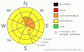
Danger Rose Tutorial
|
The danger on most slopes in the Logan Area backcountry is level 2 or Moderate, with triggered wind slab and storm snow avalanches possible at upper and mid elevations and a chance of wet avalanches down low. On some upper elevation slopes there is a level 3 or Considerable avalanche danger, and dangerous avalanche conditions exist on slopes steeper than about 35 degrees with significant fresh wind deposited snow. Careful snowpack evaluation, cautious route finding, and conservative decision making are essential at upper elevations today.... |
|
|
CURRENT CONDITIONS |

|
The Tony Grove Snotel is reporting continued heavy snowfall overnight and 1.6 inches of water equivalent in the last 24 hours. The total settled snow stake shows a 10" increase, and there's 59 inches of total snow at the site, containing 186% of average water for the date. The Campbell Scientific Logan Peak weather station is reporting diminishing northwest winds after averaging in the mid-teens overnight, but yesterday's south and west winds were sustained and fairly strong, with 50 mph gusts. It's 27 degrees at Tony Grove and 21 at 9700' on Logan Peak... |
|
|
RECENT ACTIVITY |

|
I haven't received reports of any recent avalanches locally. |
|
|
THREAT #1 |

|
| WHERE |
PROBABILITY |
SIZE |
TREND |

|
|
|
|
| |
|
|
Over the next
24 hours.
|
|
|
Soft, freshly formed wind slabs 1-3feet deep could be sensitive to human triggering. Some slabs built on thin layers of sugary or faceted snow, which can become a persistent weak layer. Be on the lookout for recent wind deposits in exposed upper elevation terrain and in and around terrain features like gullies, sub-ridges, scoops, and cliff bands. Wind slabs consist of stiffer drifted snow, have a rounded and chalky appearance, and can sound hollow or drum-like...
Today, fresh snow will be hiding drifts that were obvious yesterday, so you'll have to poke around in the snow and investigate as you go. Cracking and collapsing are bad signs indicating instability. It's always a good idea to avoid steep drifted slopes with trees or other terrain traps below. |
|
|
THREAT #2 |

|
| WHERE |
PROBABILITY |
SIZE |
TREND |

|
|
|
|
| |
|
|
Over the next
12 hours.
|
|
|
Steep slopes in the Central Bear River Range picked up a solid inch of water overnight in several inches of new snow. Expect a heightened danger of loose snow and soft slab avalanches consisting of storm snow. In recent days, I have been able to find thin shallowly buried weak layers that could be overloaded and activated by the substantial new load. |
|
|
THREAT #3 |

|
| WHERE |
PROBABILITY |
SIZE |
TREND |

|
|
|
|
| |
|
|
Over the next
8 hours.
|
|
|
Continued mild temperatures today could cause a danger of more loose wet sluffs and roller balls on steep low elevation slopes. You should avoid steep-walled gullies or creek beds..... |
|
|
MOUNTAIN WEATHER |

|
Snow showers will tapper off in the mountains this morning and a high pressure system will bring a chance of a bit of sunshine to the mountains this afternoon. A moist and mild westerly flow will set up over the region tomorrow with a chance for a bit more snow. A cold weather system will move through the region on Friday with the best chance for slightly more significant snow. Looks like a strong high pressure system will move in for the weekend, with fair weather in the mountains and inverted conditions likely in Cache Valley..... |
|
|
GENERAL ANNOUNCEMENTS |
Our Basic avalanche class with the USU Outdoor Recreation Program starts on Thursday night, December 9. Please register with the ORP in advance....
You can view a photo summary of last year's avalanche activity in the Logan Area HERE
Send us your avalanche and snow observations. You can also call me at 435-757-7578, or email to uac@utahavalanchecenter.org
Donate to your favorite non-profit – The Friends of the Utah Avalanche Center. The UAC depends on contributions from users like you to support our work.
This advisory is from the U.S.D.A. Forest Service, which is solely responsible for its content. This advisory describes general avalanche conditions and local variations always occur. |
|
|
This information does not apply to developed ski areas or highways where avalanche control is normally done. This advisory is from the U.S.D.A. Forest Service, which is solely responsible for its content. This advisory describes general avalanche conditions and local variations always occur. |
|
This advisory provided by the USDA Forest Service, in partnership with:
The Friends of the Utah Avalanche Center, Utah Division of State Parks and Recreation, Utah Division of Emergency Management, Salt Lake County, Salt Lake Unified Fire Authority and the friends of the La Sal Avalanche Center. See our Sponsors Page for a complete list. |
