SPECIAL ANNOUNCEMENT |
 |
We're offering a free backcountry avalanche awareness/Know Before You Go talk on Tuesday, December 7 at 6:00 downstairs at the Logan Ranger District office 1500 E Hwy 89 in Logan.... |
|
|
BOTTOM LINE
Danger by aspect and elevation on slopes approaching 35° or steeper.
(click HERE for tomorrow's danger rating)
|
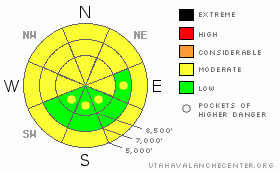
Danger Rose Tutorial
|
There is a level 2 or MODERATE avalanche danger in the backcountry, and heightened avalanche conditions exist on drifted upper and mid-elevation slopes and on slopes at lower elevations with saturated snow. In sheltered or non-drifted terrain above the rain-line there is still a level 1 or LOW danger, and avalanches are generally unlikely. Use normal caution, but evaluate the snow and terrain carefully, especially in areas with drifted or saturated snow... |
|
|
CURRENT CONDITIONS |

|
Yesterday folks found very nice riding conditions at upper and mid elevations in the Central Bear River Range, with the Tony Grove Snotel reporting a bit over 2 inches of water equivalent in the first few days of December. There's 49 inches of total snow at the site, containing 170% of average water for the date. The Campbell Scientific Logan Peak weather station is reporting 35 mph south-southeast winds, with gusts of close to 50 mph. It's currently quite warm in the mountains, with 28 degrees reported at 9700'. |
|
|
RECENT ACTIVITY |

|
I haven't received reports of any recent avalanches locally, but I noticed some more fresh loose wet activity and large roller balls yesterday on my way down canyon, and I suspect you could trigger wind slab avalanches on steep slopes near ridge-tops, with this morning's sustained and increasing south-southeast wind and plenty of soft, transportable snow at upper elevations.... |
|
|
THREAT #1 |

|
| WHERE |
PROBABILITY |
SIZE |
TREND |

|
|
|
|
| |
|
|
Over the next
24 hours.
|
|
|
Soft, freshly formed wind slabs around a foot deep could be sensitive to human triggering. Be on the lookout for recent wind deposits in exposed upper elevation terrain and in and around terrain features like gullies, sub-ridges, scoops, and cliff bands. Wind slabs consist of stiffer drifted snow, have a rounded and chalky appearance, and can sound hollow or drum-like... It's always a good idea to avoid steep drifted slopes with trees or other terrain traps below. |
|
|
THREAT #2 |

|
| WHERE |
PROBABILITY |
SIZE |
TREND |
|
|
|
|
| |
|
|
Over the next
12 hours.
|
|
|
Additional rain and mild temperatures today could cause more natural loose wet sluffs and roller balls on steep low elevation slopes. You should avoid steep-walled gullies or creek beds..... Cooling temperatures with today's storm will reduce the danger of wet avalanches as the slushy snow solidifies. |
|
|
MOUNTAIN WEATHER |

|
Expect increasing southeast winds this morning becoming southwest and moderate snowfall today, with 5 to 10 inches of accumulation forecast for upper elevations by late tonight. Mountain temperatures should drop into the upper teens by evening... Expect some clearing late tonight in advance of a brief high pressure system and fairer conditions in the mountains for tomorrow, with some sunshine possible in the afternoon. A fairly strong and somewhat moist westerly flow sets up midweek bringing another chance for snow to the mountains Wednesday and Thursday.... More significant weather is possible next weekend. |
|
|
GENERAL ANNOUNCEMENTS |
Our Basic avalanche class with the USU Outdoor Recreation Program starts on Thursday night, December 9. Please register with the ORP in advance....
You can view a photo summary of last year's avalanche activity in the Logan Area HERE
Send us your avalanche and snow observations. You can also call me at 435-757-7578, or email to uac@utahavalanchecenter.org
Donate to your favorite non-profit – The Friends of the Utah Avalanche Center. The UAC depends on contributions from users like you to support our work.
This advisory is from the U.S.D.A. Forest Service, which is solely responsible for its content. This advisory describes general avalanche conditions and local variations always occur. |
|
|
This information does not apply to developed ski areas or highways where avalanche control is normally done. This advisory is from the U.S.D.A. Forest Service, which is solely responsible for its content. This advisory describes general avalanche conditions and local variations always occur. |
|
This advisory provided by the USDA Forest Service, in partnership with:
The Friends of the Utah Avalanche Center, Utah Division of State Parks and Recreation, Utah Division of Emergency Management, Salt Lake County, Salt Lake Unified Fire Authority and the friends of the La Sal Avalanche Center. See our Sponsors Page for a complete list. |
