BOTTOM LINE
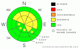
Danger by aspect and elevation on slopes approaching 35° or steeper.
(click HERE for tomorrow's danger rating)
|
Danger Rose Tutorial
|
There is a level 2 or MODERATE avalanche danger in the backcountry, and heightened avalanche conditions exist on drifted upper and mid elevation elevation slopes. In sheltered and lower elevation terrain there is a level 1 or LOW danger, and avalanches are generally unlikely. More than expected snow accumulations could cause an increase in new snow avalanche danger on steep slopes. Evaluate the snow and terrain carefully, especially in drifted areas. |
|
|
CURRENT CONDITIONS |

|
Warm temperatures and strong winds jacked the powder on most slopes, and you'll find somewhat variable riding conditions in the backcountry today. A weather disturbance passing to our north is bringing some snow to the mountains this morning and snowfall should continue for much of the day today. The Tony Grove Snotel reports 4 inches of new snow overnight and 4/10s of an inch of water in the last 24 hours. There's 46 inches of total snow containing 170% of average water for the date. The Campbell Scientific Logan Peak weather station reports sustained overnight southwest winds averaging in the 30-35 mph range and gusting into the 50's. Temperatures are dropping this morning after a warm night in the mountains, and it's currently 22 degrees at 9700', and 28 at 8400'. |
|
|
RECENT ACTIVITY |

|
No recent avalanches have been reported locally, but stiff wind slabs continue to build under sustained south and west winds and little refreshments of easily transported surface snow every couple days. I found poor structure and an easy and clean foot-deep shear yesterday below ridge-top near Logan Peak. |
|
|
THREAT #1 |

|
| WHERE |
PROBABILITY |
SIZE |
TREND |

|
|
|
|
| |
|
|
Over the next
24 hours.
|
|
|
Last night's sustained southwest wind no doubt continued to drift snow into wind slabs in exposed terrain. Wind slabs that were obvious yesterday will be hidden by today's few inches of fresh powder. Stiff older and softer freshly formed wind slabs 1-2 feet deep are likely to be sensitive to human triggering again today. These built up in exposed upper elevation terrain and in and around terrain features like gullies, sub-ridges, scoops, and cliff bands. Lee slopes below building ridge-top cornices are suspect. Wind slabs generally consist of stiffer drifted snow, often have a rounded and chalky appearance, and can sound hollow or drum-like...
It's always a good idea to avoid steep drifted slopes with trees or other terrain traps below. |
|
|
MOUNTAIN WEATHER |

|
The brunt of the storm is passing well to our north, but it is snowing in the Central Bear River Range this morning. Expect continuing periods with snowfall through today, with possible accumulations of 6 to 8 inches by tonight. Light snow is expected again tomorrow and tomorrow night without much in the way of accumulation. A mild Pacific storm will bring another modest shot of snow to the mountains on Monday, with a bit of rain possible at lower elevations.. A somewhat dry westerly flow looks like it will control the weather pattern for the later half of next week... |
|
|
GENERAL ANNOUNCEMENTS |
We're offering another free backcountry avalanche awareness/Know Before You Go talk on Tuesday, December 7 at 6:00 downstairs at the Logan Ranger District office 1500 E Hwy 89 in Logan....
You can view a photo summary of last year's avalanche activity in the Logan Area HERE
Send us your avalanche and snow observations. You can also call me at 435-757-7578, or email to uac@utahavalanchecenter.org
Donate to your favorite non-profit – The Friends of the Utah Avalanche Center. The UAC depends on contributions from users like you to support our work.
This advisory is from the U.S.D.A. Forest Service, which is solely responsible for its content. This advisory describes general avalanche conditions and local variations always occur. |
|
|
This information does not apply to developed ski areas or highways where avalanche control is normally done. This advisory is from the U.S.D.A. Forest Service, which is solely responsible for its content. This advisory describes general avalanche conditions and local variations always occur. |
|
This advisory provided by the USDA Forest Service, in partnership with:
The Friends of the Utah Avalanche Center, Utah Division of State Parks and Recreation, Utah Division of Emergency Management, Salt Lake County, Salt Lake Unified Fire Authority and the friends of the La Sal Avalanche Center. See our Sponsors Page for a complete list. |
