SPECIAL ANNOUNCEMENT |
 |
Don't miss our annual Pray for Snow party and fundraiser tonight starting at 6:30 at the Italian Place on Federal Ave in Downtown Logan, just across from the Ibis. |
|
|
BOTTOM LINE
Danger by aspect and elevation on slopes approaching 35° or steeper.
(click HERE for tomorrow's danger rating)
|
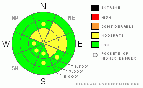
Danger Rose Tutorial
|
There is a level 2 or MODERATE avalanche danger in the backcountry, and heightened avalanche conditions exist on drifted upper and mid elevation elevation slopes. In sheltered and lower elevation terrain there is a level 1 or LOW danger, and avalanches are generally unlikely. Evaluate the snow and terrain carefully in drifted areas. |
|
|
CURRENT CONDITIONS |

|
The Tony Grove Snotel reports only a couple inches of new snow and 2/10s of an inch of water in the last 24 hours. There's 45 inches of total snow containing 11 inches of water, right around 170% of average for the date. The Campbell Scientific Logan Peak weather station reports sustained overnight southwest winds averaging in the 25 and 35 mph range. The winds appear to be diminishing and are currently from the west, and it's a balmy 20 degrees at 9700'. |
|
|
RECENT ACTIVITY |

|
Tragically,a snowmobiler from Evanston, Wyoming was killed by a hard slab avalanche in the Western Uinta Mountains on Friday. accident report. On Monday, two skiers triggered and were caught and carried a good distance by a wind slab avalanche they triggered in the Central Wasatch
Locally, riders triggered a few manageable flying saucer shaped wind slabs around 1 foot deep and up to about 35 feet wide in drifted terrain south of Tony Grove Lake. |
|
|
THREAT #1 |

|
| WHERE |
PROBABILITY |
SIZE |
TREND |
|
|
|
|
| |
|
|
Over the next
24 hours.
|
|
|
Last night's sustained southwest wind no doubt continued to drift snow into wind slabs in exposed terrain.
Stiff, freshly formed wind slabs 1-2 feet deep are likely to be sensitive to human triggering again today. These built up in exposed upper elevation terrain and in and around terrain features like gullies, sub-ridges, scoops, and cliff bands.... Lee slopes below building cornices are suspect. Wind slabs generally consist of stiffer drifted snow, often have a rounded and chalky appearance, and can sound hollow or drum-like... It's always a good idea to avoid steep drifted slopes with trees or other terrain traps below. |
|
|
THREAT #2 |

|
| WHERE |
PROBABILITY |
SIZE |
TREND |
|
|
|
|
| |
|
|
Over the next
24
hours.
|
|
|
Dangerous deep hard slab avalanches are unlikely but possible on isolated, upper elevation slopes. Hard slab avalanches, several feet deep, may fail on sugary snow under a rime-crust formed on 11-14... Although you are not likely to trigger one on most slopes today, you could on a very steep smooth slope above around 8500', and this type of avalanche could be quite large, destructive and very dangerous... |
|
|
MOUNTAIN WEATHER |

|
We'll need to watch for rime today in the mountains, which will likely have future implications. A small amount of additional snow accumulation is also possible as the southern edge of a northern storm passes over the mountains. Expect a return to high pressure conditions for Thursday and then another similar brush-by late Friday and Saturday... Models are in disagreement for the longer term and forecaster confidence is currently quite low.... |
|
|
GENERAL ANNOUNCEMENTS |
We're offering another free backcountry avalanche awareness/Know Before You Go talk on Tuesday, December 7 at 6:00 downstairs at the Logan Ranger District office 1500 E Hwy 89 in Logan....
You can view a photo summary of last year's avalanche activity in the Logan Area HERE
Send us your avalanche and snow observations. You can also call me at 435-757-7578, or email to uac@utahavalanchecenter.org
Donate to your favorite non-profit – The Friends of the Utah Avalanche Center. The UAC depends on contributions from users like you to support our work.
This advisory is from the U.S.D.A. Forest Service, which is solely responsible for its content. This advisory describes general avalanche conditions and local variations always occur. |
|
|
This information does not apply to developed ski areas or highways where avalanche control is normally done. This advisory is from the U.S.D.A. Forest Service, which is solely responsible for its content. This advisory describes general avalanche conditions and local variations always occur. |
|
This advisory provided by the USDA Forest Service, in partnership with:
The Friends of the Utah Avalanche Center, Utah Division of State Parks and Recreation, Utah Division of Emergency Management, Salt Lake County, Salt Lake Unified Fire Authority and the friends of the La Sal Avalanche Center. See our Sponsors Page for a complete list. |
