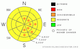
BOTTOM LINE
Danger by aspect and elevation on slopes approaching 35° or steeper.
(click HERE for tomorrow's danger rating)
|
Danger Rose Tutorial
|
There is a level 2 or MODERATE avalanche danger in the backcountry, and heightened avalanche conditions exist on drifted upper and mid elevation elevation slopes and on steep slopes with significant deposits of new snow. Triggered wind slab, storm snow, and isolated deep slab avalanches are possible, especially in steep exposed terrain... There are also pockets with a Level 3, CONSIDERABLE danger in exposed terrain at upper and mid elevations. Evaluate the snow and terrain carefully, and use cautious route finding and conservative decision making in drifted terrain... |
|
|
CURRENT CONDITIONS |

|
Yesterday's storm put down some nice powder in the Logan Area , but looks like more snow in town than at upper elevations in the Bear River Range. Sustained northwest winds yesterday built sizable drifts and sensitive soft slabs with the light density snow on upper elevation lee side slopes. We found nice arctic shallow powder conditions yesterday, with the best snow in sheltered shady terrain and in the trees....From the northwest flow, you might find more new snow in the southern Bear River Range and Logan Peak Area today..
The Tony Grove Snotel reports only a few inches of new snow and 3/10s of an inch of water in the last 24 hours. There's 49 inches of total snow containing 10.9 inches of water. The Campbell Scientific Logan Peak weather station reports sustained 15-20 mph winds out of the north-northwest overnight.and it's 3 degrees at 9700'. |
|
|
RECENT ACTIVITY |

|
Tragically,a snowmobiler from Evanston, Wyoming was killed by a hard slab avalanche in the Western Uinta Mountains on Friday. Our condolences go out to his family and friends. Our Western Uinta staff have posted an accident report.
Locally, I noticed evidence a fair amount of natural activity at upper elevations from during the productive and windy storm last week. Some of these were large and substantial hard slab avalanches....see list
Yesterday, we triggered several manageable sensitive wind slabs up to a foot deep in drifted upper elevation terrain in the Cornice Ridge Area. Some of these soft slabs cracked out and propagated a good distance up the ridge from the trigger, but non ran far or really packed much of a punch.... |
|
|
THREAT #1 |

|
| WHERE |
PROBABILITY |
SIZE |
TREND |
|
|
|
|
| |
|
|
Over the next
24 hours.
|
|
|
Stiff, freshly formed wind slabs 1-2 feet deep are likely to still be sensitive to human triggering today. These built up in exposed upper elevation terrain and in and around terrain features like gullies, sub-ridges, scoops, and cliff bands.... Lee slopes below building cornices are suspect. It's always a good idea to avoid steep drifted slopes with trees or other terrain traps below. |
|
|
THREAT #2 |

|
| WHERE |
PROBABILITY |
SIZE |
TREND |

|
|
|
|
| |
|
|
Over the next
24 hours.
|
|
|
Yesterday's light snow did not bond well with the old snow surface and many steep slopes produced natural loose snow sluffs. We also easily triggered loose snow and small soft slab avalanches yesterday. Although generally manageable, you should be aware of and avoid slopes where the sluffing snow could engulf you in a gully or smack you into trees below. |
|
|
THREAT #3 |

|
| WHERE |
PROBABILITY |
SIZE |
TREND |
|
|
|
|
| |
|
|
Over the next
24 hours.
|
|
|
Dangerous deep hard slab avalanches are possible on isolated, upper elevation slopes. Hard slab avalanches, several feet deep, may fail on sugary snow under a rime-crust formed on 11-14... Although you are not likely to trigger one on most slopes today, you could on a very steep smooth slope above around 8500', and this type of avalanche could be quite large, destructive and very dangerous... |
|
|
MOUNTAIN WEATHER |

|
The storm will move off the the south and east today and we'll see only a few lingering showers this morning as mountain temperatures slowly moderate. Temperatures will drop below zero again tonight, but should rebound to near 20 degrees tomorrow. Our next chance of snow comes Tuesday night and Wednesday, with a storm passing to the north. Another storm develops next weekend, but the models disagree as to timing and intensity. A gradual warming trend is mentioned in the longer term forecast... |
|
|
GENERAL ANNOUNCEMENTS |
Don't miss our annual Pray for Snow party and fundraiser, Wednesday December 1st at the Italian Place.
We're offering another free backcountry avalanche awareness/Know Before You Go talk on Tuesday, December 7 at 6:00 downstairs at the Logan Ranger District office 1500 E Hwy 89 in Logan....
You can view a photo summary of last year's avalanche activity in the Logan Area HERE
Send us your avalanche and snow observations. You can also call me at 435-757-7578, or email to uac@utahavalanchecenter.org
Donate to your favorite non-profit – The Friends of the Utah Avalanche Center. The UAC depends on contributions from users like you to support our work.
This advisory is from the U.S.D.A. Forest Service, which is solely responsible for its content. This advisory describes general avalanche conditions and local variations always occur. |
|
|
This information does not apply to developed ski areas or highways where avalanche control is normally done. This advisory is from the U.S.D.A. Forest Service, which is solely responsible for its content. This advisory describes general avalanche conditions and local variations always occur. |
|
This advisory provided by the USDA Forest Service, in partnership with:
The Friends of the Utah Avalanche Center, Utah Division of State Parks and Recreation, Utah Division of Emergency Management, Salt Lake County, Salt Lake Unified Fire Authority and the friends of the La Sal Avalanche Center. See our Sponsors Page for a complete list. |
