SPECIAL ANNOUNCEMENT |
 |
Tragically, a snowmobiler from Evanston, Wyoming was killed yesterday in an avalanche he triggered in the Uinta Mountains in the Moffit Basin area. Our condolences go out to his family and friends. He was apparently a high-end rider and well-known in the community. It appears that they left their avalanche rescue gear in their vehicles because they did not plan to get onto any avalanche terrain but it appears that the victim triggered the avalanche from mid slope in Super Bowl, a popular snowmobile play area. We have a preliminary report and Craig Gordon will post a more complete report tonight after he returns from visiting the accident site today. |
|
|
BOTTOM LINE
Danger by aspect and elevation on slopes approaching 35° or steeper.
(click HERE for tomorrow's danger rating)
|
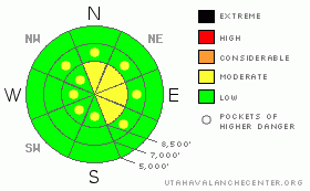
Danger Rose Tutorial
|
There is a level 2 or MODERATE avalanche danger in the backcountry, and heightened avalanche conditions exist on drifted upper elevation slopes. Triggered wind slab and isolated deep slab avalanches are possible in steep exposed terrain...Evaluate the snow and terrain carefully. You'll find a safer, level 1 or LOW danger at lower elevations and in sheltered terrain.
Expect an increasing avalanche danger tomorrow with a Winter Storm Warning, heavy snowfall, and winds... |
|
|
CURRENT CONDITIONS |

|
The productive storm earlier this week filled in the rocky upper elevation terrain across the region with several feet of dense and drifted snow. Lower elevations also did fairly well, but there's only a foot or less at most trailheads and front side canyons. Winds have damaged the snow surface in exposed areas, but sheltered slopes are still soft and powdery....
The Tony Grove Snotel reports 47 inches of total snow containing 10.4 inches of water. South winds picked up overnight at the Campbell Scientific Logan Peak weather station, with gusts in the 40 mph range. It's 18 degrees at 9700'. |
|
|
RECENT ACTIVITY |

|
I could finally see yesterday, and I noticed evidence a fair amount of natural activity at upper elevations from during the productive and windy storm earlier in the week. Some of these were large and substantial hard slab avalanches....see list |
|
|
THREAT #1 |

|
| WHERE |
PROBABILITY |
SIZE |
TREND |

|
|
|
|
| |
|
|
Over the next
24 hours.
|
|
|
Stiff, freshly formed wind slabs 1-2 feet deep or deeper may be sensitive to human triggering today. These most likely built up in exposed upper elevation terrain and in and around terrain features like gullies, sub-ridges, scoops, and cliff bands.... Lee slopes below building cornices are suspect. Always a good idea to avoid steep drifted slopes with trees or other terrain traps below. |
|
|
THREAT #2 |

|
| WHERE |
PROBABILITY |
SIZE |
TREND |
|
|
|
|
| |
|
|
Over the next
24 hours.
|
|
|
Dangerous deep hard slab avalanches are possible on isolated, upper elevation slopes with generally shallow snow cover and recent drifting...... |
|
|
MOUNTAIN WEATHER |

|
Expect warming temperatures today, and a southerly wind will continue to pick up ahead of the next Pacific storm, which should bring another good shot of snow beginning late tonight and lasting through Sunday night... The National Weather service has issued a Winter Storm Warning for the mountains... 1-2+ feet of powdery accumulation are forecast for upper elevations by Monday morning. We're hoping for fairly light density snow....
It looks like a progressive weather pattern for next week, and after a short-lived break early in the week, more storms are likely...... |
|
|
GENERAL ANNOUNCEMENTS |
Don't miss our annual Pray for Snow party and fundraiser, Wednesday December 1st at the Italian Place.
We're offering another free backcountry avalanche awareness/Know Before You Go talk on Tuesday, December 7 at 6:00 downstairs at the Logan Ranger District office 1500 E Hwy 89 in Logan....
You can view a photo summary of last year's avalanche activity in the Logan Area HERE
Send us your avalanche and snow observations. You can also call me at 435-757-7578, or email to uac@utahavalanchecenter.org
Donate to your favorite non-profit – The Friends of the Utah Avalanche Center. The UAC depends on contributions from users like you to support our work.
This advisory is from the U.S.D.A. Forest Service, which is solely responsible for its content. This advisory describes general avalanche conditions and local variations always occur. |
|
|
This information does not apply to developed ski areas or highways where avalanche control is normally done. This advisory is from the U.S.D.A. Forest Service, which is solely responsible for its content. This advisory describes general avalanche conditions and local variations always occur. |
|
This advisory provided by the USDA Forest Service, in partnership with:
The Friends of the Utah Avalanche Center, Utah Division of State Parks and Recreation, Utah Division of Emergency Management, Salt Lake County, Salt Lake Unified Fire Authority and the friends of the La Sal Avalanche Center. See our Sponsors Page for a complete list. |
