SPECIAL ANNOUNCEMENT |
 |
We're issuing a Special Avalanche Advisory for the the Mountains of Northern Utah. Significant new snow accumulation and strong winds have created dangerous avalanche conditions in the backcountry. Avoid steep drifted slopes at upper elevations... Careful snowpack evaluation, cautious route finding, and conservative decision making are essential today.... Those without proper avalanche training and experience should avoid steep mountain slopes for the next few days. |
|
|
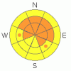
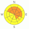
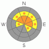
BOTTOM LINE
Danger by aspect and elevation on slopes approaching 35° or steeper.
(click HERE for tomorrow's danger rating)
|
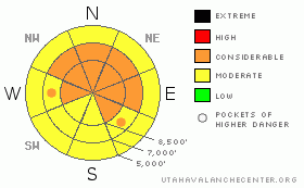
Danger Rose Tutorial
|
The avalanche danger remains level 3 or CONSIDERABLE, and dangerous avalanche conditions exist in the backcountry, especially on drifted slopes at upper elevations. Careful snowpack evaluation, cautious route finding, and conservative decision making are essential today.... |
|
|
CURRENT CONDITIONS |

|
The Bear River Range boasts impressive storm totals, with local Snotel sites reporting around 5 feet of new snow, containing over 5" of water since early Saturday morning. The Tony Grove Snotel at 8400' reports another 10 inches of new snow containing 8/10ths of an inch of water from yesterday and overnight. There's now at total of 60 inches of settled snow on the ground containing 10.2 inches of water equivalent, and the station is currently sitting at nearly 200% of average for the date... It's very cold in the mountains this morning, with Tony Grove Reporting -6 degrees and Logan Peak at negative 13. The wind is from the west this morning at 9700', averaging 12 mph... The Campbell Scientific weather station on Logan Peak recorded southwest wind gusts of over 70 mph yesterday.
The Tony Grove Road is not maintained for wheeled vehicles in the winter. Deep and drifted snow now covers the road. Riders need to watch for and slow down for pedestrians...... |
|
|
RECENT ACTIVITY |

|
No significant avalanches have been reported or observed in the Logan Area.... Please report any sightings of evidence of probable recent natural avalanche activity..... |
|
|
THREAT #1 |

|
| WHERE |
PROBABILITY |
SIZE |
TREND |
|
|
|
|
| |
|
|
Over the next
24 hours.
|
|
|
Stiff, freshly formed wind slabs 3-6 feet deep or deeper may be sensitive to human triggering today. These are most likely in exposed upper elevation terrain and in and around terrain features like gullies, sub-ridges, scoops, and cliff bands.... Areas with small cornices and ridge-top areas where cornices usually form are likely to have substantial freshly deposited drifts and wind slabs today. |
|
|
THREAT #2 |

|
| WHERE |
PROBABILITY |
SIZE |
TREND |
|
|
|
|
| |
|
|
Over the next
24 hours.
|
|
|
Significant triggered loose new snow and soft slab avalanches are likely on steep slopes.... It would be easy to get a lot of soft snow moving down a very steep slope. Be mindful of trees of other terrain traps below. |
|
|
THREAT #3 |

|
| WHERE |
PROBABILITY |
SIZE |
TREND |
|
|
|
|
| |
|
|
Over the next
24
hours.
|
|
|
And, with all the additional load, some avalanches might step down into an existing sugary weak layer capped by a thin brittle rime-crust from 11/12. Some of the larger recent avalanches in the Central Wasatch Range show that some slopes do have this potential. In some areas, dangerous avalanches could be triggered from a distance, or worse, from below.... |
|
|
MOUNTAIN WEATHER |

|
Expect very cold temperatures today to continue to drop into evening and sub-zero readings again tonight. Snowfall will diminish in the mountains today, yielding to partly cloudy conditions and a cold Thanksgiving Day...
Another fairly impressive string of storms looks likely for early next week, with the first car in the storm train tentatively scheduled for Saturday evening........ |
|
|
GENERAL ANNOUNCEMENTS |
Don't miss our annual Pray for Snow party and fundraiser, Wednesday December 1st at the Italian Place.
Send us your avalanche and snow observations. You can also call me at 435-757-7578, or email to uac@utahavalanchecenter.org
Donate to your favorite non-profit – The Friends of the Utah Avalanche Center. The UAC depends on contributions from users like you to support our work.
This advisory is from the U.S.D.A. Forest Service, which is solely responsible for its content. This advisory describes general avalanche conditions and local variations always occur. |
|
|
This information does not apply to developed ski areas or highways where avalanche control is normally done. This advisory is from the U.S.D.A. Forest Service, which is solely responsible for its content. This advisory describes general avalanche conditions and local variations always occur. |
|
This advisory provided by the USDA Forest Service, in partnership with:
The Friends of the Utah Avalanche Center, Utah Division of State Parks and Recreation, Utah Division of Emergency Management, Salt Lake County, Salt Lake Unified Fire Authority and the friends of the La Sal Avalanche Center. See our Sponsors Page for a complete list. |
