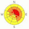
BOTTOM LINE
Danger by aspect and elevation on slopes approaching 35° or steeper.
(click HERE for tomorrow's danger rating)
|
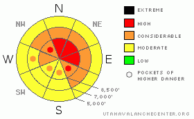
Danger Rose Tutorial
|
The backcountry avalanche danger is level 3 (or CONSIDERABLE,) and dangerous avalanche conditions exist, especially on drifted slopes at upper elevations. Some natural avalanches are possible and triggered avalanches are likely on slopes steeper than about 30 degrees. In some upper elevation areas, continued heavy snowfall and strong west winds today could easily cause the danger to rise to level 4 (or HIGH,) and you should avoid obvious or historic avalanche paths and steep drifted slopes. Careful snowpack evaluation, cautious route finding and conservative decision making will be essential in the backcountry today.... |
|
|
CURRENT CONDITIONS |

|
The Bear River Range boasts impressive two-day storm totals of around 3' of snow containing about 3" of water since Saturday morning. The Tony Grove Snotel at 8400' reports another foot of new snow containing 1" of water from yesterday and overnight. There's now 49 inches of total snow on the ground containing over 8 inches of water equivalent, and the station is currently sitting at 167% of average for the date...
I'm reading moderate southwest winds at the moment on Logan Peak, and a chilly 9 degrees at 9700'.
The Tony Grove Road is not maintained for wheeled vehicles in the winter. Expect patches of ice, deepening snow, and deteriorating driving conditions. The storm upon us will most likely spell the end of driving to the lake for the season, as the upper section will probably become impassable..... In fact, numerous 4x4s got stuck on the road yesterday, and nobody was able to drive all the way up to the lake.... |
|
|
RECENT ACTIVITY |

|
Numerous triggered and a few natural avalanches were reported in the Central Wasatch Range yesterday. These were failing on weaknesses within the new snow as well as on buried persistent weak layers....see list
Locally yesterday, I easily and intentionally triggered a shallow (<6"deep) soft slab in far east Miller Bowl, south of Tony Grove Lake with a ski cut. The small (40' wide) new snow avalanche ran a ways through trees below and triggered a similar sized sympathetic release under the East Miller Chute. |
|
|
THREAT #1 |

|
| WHERE |
PROBABILITY |
SIZE |
TREND |
|
|
|
|
| |
|
|
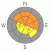
Over the next
24 hours.
|
|
|
The danger of storm snow and wind slab avalanches will continue at upper elevations, with another foot of accumulation possible today and strong west winds. Significant new snow avalanches are possible with potential failing layers produced by subtle weather changes within the storm...
Expect to find extensive drifting in exposed terrain. Freshly formed wind slabs 2-3 feet deep are most likely in exposed upper elevation terrain and in and around terrain features like gullies, scoops, and cliff bands.... Areas with small cornices and ridge-top areas where cornices usually form are likely to have substantial freshly deposited drifts today. Resuming west winds, along with more snowfall may well cause the danger to increase and become more widespread.... |
|
|
THREAT #2 |

|
| WHERE |
PROBABILITY |
SIZE |
TREND |
|
|
|
|
| |
|
|
Over the next
24
hours.
|
|
|
And, with all the additional load, some avalanches might step down into an existing weak layer that was near the snow surface last weekend and capped by a thin brittle rime-crust last Sunday. Avalanches could be triggered from a distance, or worse, from below.... |
|
|
MOUNTAIN WEATHER |

|
The National Weather Service has continued a Winter Storm Warning for our region through Wednesday morning. Another foot of accumulation is possible at higher elevations today, and more snow will likely also accumulate in the valleys as temperatures continue drop. The coldest and strongest wave in this sustained winter storm will bring dangerous blizzard conditions to the mountains and valleys late tomorrow..... Snowfall will taper off on Wednesday, but snow showers will likely linger into a chilly Thanksgiving Day.
The next round of storminess arrives next weekend..... |
|
|
GENERAL ANNOUNCEMENTS |
Don't miss our annual Pray for Snow party and fundraiser, Wednesday December 1st at the Italian Place.
Send us your avalanche and snow observations. You can also call me at 435-757-7578, or email to uac@utahavalanchecenter.org
Donate to your favorite non-profit – The Friends of the Utah Avalanche Center. The UAC depends on contributions from users like you to support our work.
This advisory is from the U.S.D.A. Forest Service, which is solely responsible for its content. This advisory describes general avalanche conditions and local variations always occur. |
|
|
This information does not apply to developed ski areas or highways where avalanche control is normally done. This advisory is from the U.S.D.A. Forest Service, which is solely responsible for its content. This advisory describes general avalanche conditions and local variations always occur. |
|
This advisory provided by the USDA Forest Service, in partnership with:
The Friends of the Utah Avalanche Center, Utah Division of State Parks and Recreation, Utah Division of Emergency Management, Salt Lake County, Salt Lake Unified Fire Authority and the friends of the La Sal Avalanche Center. See our Sponsors Page for a complete list. |
