AVALANCHE WARNING »
Dangerous avalanche conditions are occuring or are imminent.
Backcountry travel in avalanche terrain is not recommended.
|
 |
Notice: An Avalanche Warning has been issued for the Wasatch, Western Uintas and Bear River Ranges. Recent snow and strong winds have created sensitive avalanche conditions along high elevation ridges. To stay out of avalanche danger, do not travel in terrain approaching 35 degrees in steepness with recent deposits of wind drifted snow. People without expert level snow and avalanche assessment skills should avoid backcountry travel today. |
|
|
BOTTOM LINE
Danger by aspect and elevation on slopes approaching 35° or steeper.
(click HERE for tomorrow's danger rating)
|
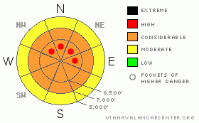
Danger Rose Tutorial
|
The backcountry avalanche danger is at level 3 or CONSIDERABLE, and dangerous avalanche conditions exist on drifted slopes at upper elevations this morning. Some natural avalanches are possible and triggered avalanches are likely. Resuming heavy snowfall and strong winds today could easily cause the danger to rise to level 4 or HIGH in some areas by this evening, and a natural avalanche cycle overnight is possible...
Careful snowpack evaluation, cautious route finding and conservative decision making will be essential today.... |
|
|
CURRENT CONDITIONS |

|
We'll continue to see rising avalanche danger in the backcountry today. South winds should pick up again soon, and heavy snowfall and strong winds are expected by afternoon, as the second and colder wave of a major winter storm pummels the region. The Tony Grove Snotel reports at least 19 inches of new snow containing 2" of water from yesterday and 38 inches of total snow on the ground. I'm reading fairly calm and shifty winds at the moment on Logan Peak, with sustained strong winds and a gust of 63 mph recorded yesterday.
The Tony Grove Road is not maintained for wheeled vehicles in the winter. Expect patches of ice, deepening snow, and deteriorating driving conditions. The storm upon us will most likely spell the end of driving to the lake for the season, as the upper section will probably become impassable..... |
|
|
RECENT ACTIVITY |

|
A Party of backcountry skiers triggered some wind slab avalanches in exposed terrain in the Central Wasatch yesterday..
Locally, I've not received reports of any new avalanches yet, but I'll be surprised if we go through the weekend without any observed activity.... |
|
|
THREAT #1 |

|
| WHERE |
PROBABILITY |
SIZE |
TREND |

|
|
|
|
| |
|
|
Over the next
24 hours.
|
|
|
The danger of wind slab avalanches will continue to rise today. With strong southwest and and west winds and heavy snowfall yesterday, expect to already find extensive drifting in exposed terrain. You are likely to find freshly formed wind slabs 2-3 feet deep, most likely in exposed upper elevation terrain and in and around terrain features like gullies, scoops, and cliff bands.... Areas with small cornices and ridge-top areas where cornices usually form are likely to have substantial freshly deposited drifts today. Resuming south and west winds along with more snowfall could cause the danger to increase and become more widespread. |
|
|
THREAT #2 |

|
| WHERE |
PROBABILITY |
SIZE |
TREND |
|
|
|
|
| |
|
|
Over the next
12 hours.
|
|
|
The danger of storm snow avalanches will continue to rise, with a couple feet of accumulation possible today. Significant new snow avalanches are possible with potential failing layers produced by subtle weather changes within the storm...
And with all the additional load, some avalanches might step down into an existing weak layer that was near the snow surface last weekend and capped by a thin brittle rime-crust last Sunday |
|
|
MOUNTAIN WEATHER |

|
The National Weather Service has continued a Winter Storm Warning for our region, and it looks like we're in for part 2 of a major storm, which will last well into next week... 1-2-more feet of snow are possible at higher elevations today, and more snow will likely also accumulate in the valleys as temperatures drop. Expect south winds to redevelop this morning, and snowfall will become heavy again this afternoon as the next, colder wave of the storm system approaches... |
|
|
GENERAL ANNOUNCEMENTS |
Don't miss our annual Pray for Snow party and fundraiser, Wednesday December 1st at the Italian Place.
Send us your avalanche and snow observations. You can also call me at 435-757-7578, or email to uac@utahavalanchecenter.org
Donate to your favorite non-profit – The Friends of the Utah Avalanche Center. The UAC depends on contributions from users like you to support our work.
This advisory is from the U.S.D.A. Forest Service, which is solely responsible for its content. This advisory describes general avalanche conditions and local variations always occur. |
|
|
This information does not apply to developed ski areas or highways where avalanche control is normally done. This advisory is from the U.S.D.A. Forest Service, which is solely responsible for its content. This advisory describes general avalanche conditions and local variations always occur. |
|
This advisory provided by the USDA Forest Service, in partnership with:
The Friends of the Utah Avalanche Center, Utah Division of State Parks and Recreation, Utah Division of Emergency Management, Salt Lake County, Salt Lake Unified Fire Authority and the friends of the La Sal Avalanche Center. See our Sponsors Page for a complete list. |
