AVALANCHE WATCH »
The risk of an avalanche is expected to increase significantly
but the timing and location are still uncertain. Stay tuned for updates.
|
 |
Notice: An Avalanche Watch has been issued for the mountains of northern Utah. Periods of heavy snow and strong winds will create increasingly dangerous avalanche conditions Saturday afternoon through Tuesday..especially above 8,000'. People without avalanche training should avoid backcountry terrain. |
|
|
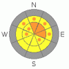
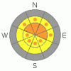
BOTTOM LINE
Danger by aspect and elevation on slopes approaching 35° or steeper.
(click HERE for tomorrow's danger rating)
|

Danger Rose Tutorial
|
The avalanche danger is at level 2, or MODERATE on drifted slopes at upper elevations this morning, but will quickly rise to level 3 and become more widespread as the storm intensifies today. Triggered wind slab, storm snow and/or persistent slab avalanches will be likely on slopes steeper than about 35 degrees, and natural avalanches may occur overnight. Careful snowpack evaluation, cautious route finding and conservative decision making will be essential today.... |
|
|
CURRENT CONDITIONS |

|
We'll see a rapidly rising avalanche danger this weekend in the backcountry. Heavy snowfall and strong south winds are already slamming into the mountains this morning as the first blow of a major winter storm hits the region. The Tony Grove Snotel reports a couple inches of new snow and a total of 22 inches of snow on the ground, containing 5.2 inches of water equivalent... The station reads116% of average for the date. A south-southwest wind remains strong this morning on Logan Peak, with a gust of 57 mph recorded early this morning. It's a balmy 25 degrees at 9700'.
I was surprised how well the heavy new snow filled in the terrain. Areas that were shallow or bare last week are now fairly well covered, but you still have to watch for shallowly buried rocks and keep your speed down....The Tony Grove Road is not maintained for wheeled vehicles in the winter. Expect patches of ice, deepening snow, and deteriorating driving conditions. The storm upon us will most likely spell the end of driving to the lake for the season, as the upper section will probably become impassable..... |
|
|
RECENT ACTIVITY |

|
A handful of sizable wind slab avalanches were triggered over the week in Northern Utah...These ranged from around a foot to 3 feet deep and could easily have carried or buried you if you got caught.... Locally, we noticed evidence of a recent natural or remote triggered soft slab avalanche from sometime during Tuesday's storm. South of Tony Grove Lake on Wednesday, The 1' deep avalanche on a fairly popular slope involved heavy new snow, and could easily have knocked you into trees lower on the slope. |
|
|
THREAT #1 |

|
| WHERE |
PROBABILITY |
SIZE |
TREND |
|
|
|
|
| |
|
|
Over the next
24 hours.
|
|
|
The danger of wind slab avalanches will rise quickly today. With strong southwest and and west winds and heavy snowfall in today's forecast, expect extensive drifting in exposed terrain. You are likely to find freshly formed wind slabs a couple feet deep by this afternoon... Wind slabs usually are found in exposed upper elevation terrain and in and around terrain features like gullies, scoops, and cliff bands.... Areas where cornices usually form are likely to have freshly deposited drifts. |
|
|
THREAT #2 |

|
| WHERE |
PROBABILITY |
SIZE |
TREND |
|
|
|
|
| |
|
|
Over the next
12 hours.
|
|
|
The danger of storm snow avalanches will rise drastically this weekend, with a couple feet of accumulation likely. It is possible that some avalanches might step down into an existing weak layer that was near the snow surface last weekend and capped by a thin brittle rime-crust last Sunday |
|
|
MOUNTAIN WEATHER |

|
Snowfall and strong winds are already pounding the mountains this morning... The National Weather Service has issued a Winter Storm Warning for our region, and it looks like we're in for a major storm, which will last through the weekend and into next week... Two to three feet of snow are possible at higher elevations and snow will likely also accumulate in the valleys as temperatures plummit. Also, westerly winds will be quite strong throughout. |
|
|
GENERAL ANNOUNCEMENTS |
Don't miss our annual Pray for Snow party and fundraiser, Wednesday December 1st at the Italian Place.
Send us your avalanche and snow observations. You can also call me at 435-757-7578, or email to uac@utahavalanchecenter.org
Donate to your favorite non-profit – The Friends of the Utah Avalanche Center. The UAC depends on contributions from users like you to support our work.
This advisory is from the U.S.D.A. Forest Service, which is solely responsible for its content. This advisory describes general avalanche conditions and local variations always occur. |
|
|
This information does not apply to developed ski areas or highways where avalanche control is normally done. This advisory is from the U.S.D.A. Forest Service, which is solely responsible for its content. This advisory describes general avalanche conditions and local variations always occur. |
|
This advisory provided by the USDA Forest Service, in partnership with:
The Friends of the Utah Avalanche Center, Utah Division of State Parks and Recreation, Utah Division of Emergency Management, Salt Lake County, Salt Lake Unified Fire Authority and the friends of the La Sal Avalanche Center. See our Sponsors Page for a complete list. |
