BOTTOM LINE
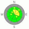
Danger by aspect and elevation on slopes approaching 35° or steeper.
(click HERE for tomorrow's danger rating)
|

Danger Rose Tutorial
|
The avalanche danger remains at level 2, or MODERATE on drifted slopes at upper elevations. Triggered wind slab and/or persistent slab avalanches are possible on north through east facing slopes steeper than about 35 degrees. |
|
|
CURRENT CONDITIONS |

|
The Tony Grove Snotel reports 21 inches of total snow on the ground, containing 5.2 inches of water equivalent... The station reads120% of average for the date. A southwest wind remains strong this morning on Logan Peak, as it has been since yesterday, with gusts in the 50 mph range. It's a balmy 27 degrees at 9700'. I was surprised how well the heavy new snow filled in the terrain. Areas that were shallow or bare last week are now fairly well covered, but you still have to watch for shallowly buried rocks and keep your speed down....
The Tony Grove Road is not maintained for wheeled vehicles in the winter. Expect patches of ice, deepening snow, and deteriorating driving conditions. |
|
|
RECENT ACTIVITY |

|
South of Tony Grove Lake on Wednesday, we noticed evidence of a recent natural or remote triggered soft slab avalanche from sometime during Tuesday's storm. The 1' deep avalanche on a fairly popular slope involved heavy new snow, and could easily have knocked you into trees lower on the slope. |
|
|
THREAT #1 |

|
| WHERE |
PROBABILITY |
SIZE |
TREND |
|
|
|
|
| |
|
|
Over the next
24 hours.
|
|
|
Wind slabs usually are found in exposed upper elevation terrain and in and around terrain features like gullies, scoops, and cliff bands.... Areas where cornices usually form are likely to have freshly deposited drifts. |
|
|
THREAT #2 |

|
| WHERE |
PROBABILITY |
SIZE |
TREND |

|
|
|
|
| |
|
|
Over the next
12 hours.
|
|
|
Looks like the slab formed on a somewhat weak underlying structure. Small grained sugar-like facets formed under substantial temperature gradient in the shallow snow from last week. A thin, brittle rime-crust capped the facets on Sunday, and a much heaver, wind drifted, and stiff slab came with Monday and Tuesday's heavy snowfall....
Tests currently are showing much improved stability on this layer, but we'll need to watch it as a slab builds up with incoming storm. |
|
|
MOUNTAIN WEATHER |

|
The National Weather Service has issued a Winter Storm Watch for our region, and it looks like we're in for a fairly major storm, which will last through the weekend... Snowfall will likely begin tonight and pick up in intensity on Saturday and into Sunday... Also, westerly winds will be quite strong throughout. Precipitation will likely begin as rain in the valleys, but will soon turn to snow even at the lower elevations.... Looks like stormy weather will continue well into Thanksgiving week... |
|
|
GENERAL ANNOUNCEMENTS |
Don't miss our annual Pray for Snow party and fundraiser, Wednesday December 1st at the Italian Place.
Send us your avalanche and snow observations. You can also call me at 435-757-7578, or email to uac@utahavalanchecenter.org
Donate to your favorite non-profit – The Friends of the Utah Avalanche Center. The UAC depends on contributions from users like you to support our work.
This advisory is from the U.S.D.A. Forest Service, which is solely responsible for its content. This advisory describes general avalanche conditions and local variations always occur. |
|
|
This information does not apply to developed ski areas or highways where avalanche control is normally done. This advisory is from the U.S.D.A. Forest Service, which is solely responsible for its content. This advisory describes general avalanche conditions and local variations always occur. |
|
This advisory provided by the USDA Forest Service, in partnership with:
The Friends of the Utah Avalanche Center, Utah Division of State Parks and Recreation, Utah Division of Emergency Management, Salt Lake County, Salt Lake Unified Fire Authority and the friends of the La Sal Avalanche Center. See our Sponsors Page for a complete list. |
