BOTTOM LINE
Danger by aspect and elevation on slopes approaching 35° or steeper.
(click HERE for tomorrow's danger rating)
|
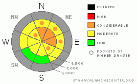
Danger Rose Tutorial
|
Despite clearing conditions, the avalanche danger remains at level 3 or Considerable on drifted slopes at upper elevations. Dangerous triggered wind slab and persistent slab avalanches are probable on north and east facing slopes steeper than about 35 degrees. Careful snowpack evaluation, cautious route finding and conservative decision-making are essential today.... |
|
|
CURRENT CONDITIONS |

|
The Tony Grove Snotel reports a couple more inches of snow overnight and 2.2 inches of water equivalent since Sunday afternoon. The station reports 23 inches of total snow on the ground. The new snow is fairly heavy and wind drifted, and it appears to hold some desert dust.After gusts nearing 60 mph yesterday, the wind sensor at 9700' on Logan Peak this morning reports fairly calm conditions under a light northerly flow, and its a chilly14 degrees. I was surprised how well the new snow filled in the terrain. Areas that were shallow or bare last week are now fairly well covered, but you still have to watch for shallowly buried rocks and keep your speed down....
The Tony Grove Road is not maintained for wheeled vehicles in the winter. Expect patches of ice, deepening snow, and deteriorating driving conditions. |
|
|
RECENT ACTIVITY |

|
Backcountry skiers remote triggered a few significant avalanches yesterday in wind drifted terrain in the Wasatch Range. No recent avalanche activity has been observed locally, but my party triggered numerous audible collapses or whumphing noises, some along with very thin shooting cracks in relatively low angled terrain south of Tony Grove Lake. Snow pit tests revealed fairly easy shears with full slab propagation failing just below Sunday's brittle rime-crust... |
|
|
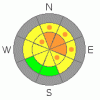
THREAT #1 |

|
| WHERE |
PROBABILITY |
SIZE |
TREND |
|
|
|
|
| |
|
|
Over the next
24 hours.
|
|
|
You will find freshly built, stiff wind slabs 1 to 3 feet deep in exposed upper elevation terrain today. Many of these slabs are likely to be sensitive to your weight, and some could be triggered from a distance.
Wind slabs usually are found in exposed upper elevation terrain and in and around terrain features like gullies, scoops, and cliff bands.... Areas where cornices usually form are likely to have deep freshly deposited drifts today...... |
|
|
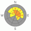
THREAT #2 |

|
| WHERE |
PROBABILITY |
SIZE |
TREND |
|
|
|
|
| |
|
|
Over the next
12 hours.
|
|
|
Looks like the slab formed on a somewhat weak underlying structure. Small grained sugar-like facets formed under substantial temperature gradient in the shallow snow from last week. A thin, brittle rime-crust capped the facets on Sunday, and a much heaver, wind drifted, and stiff slab came with Monday and Tuesday's heavy snowfall....
I'm afraid this poor snow structure may haunt us for a while.... |
|
|
MOUNTAIN WEATHER |

|
A high pressure system will control the weather for the next couple days. Expect sunshine and warming conditions in the mountains today.... Cloud cover should keep temperatures on the mild side overnight, and south winds will pick up, mixing and warming the valleys on Thursday and Friday.... Snowfall is likely over the weekend, and the models are showing potentially significant storminess around early next week. |
|
|
GENERAL ANNOUNCEMENTS |
Don't miss our annual Pray for Snow party and fundraiser, Wednesday December 1st at the Italian Place.
We're offering a free avalanche awareness/ Know Before You Go Talk on Thursday, November 18, 6:00 pm, at the Logan Ranger District Offices, 1500 E. Hwy 89
Send us your avalanche and snow observations. You can also call me at 435-757-7578, or email to uac@utahavalanchecenter.org
Donate to your favorite non-profit – The Friends of the Utah Avalanche Center. The UAC depends on contributions from users like you to support our work.
This advisory is from the U.S.D.A. Forest Service, which is solely responsible for its content. This advisory describes general avalanche conditions and local variations always occur. |
|
|
This information does not apply to developed ski areas or highways where avalanche control is normally done. This advisory is from the U.S.D.A. Forest Service, which is solely responsible for its content. This advisory describes general avalanche conditions and local variations always occur. |
|
This advisory provided by the USDA Forest Service, in partnership with:
The Friends of the Utah Avalanche Center, Utah Division of State Parks and Recreation, Utah Division of Emergency Management, Salt Lake County, Salt Lake Unified Fire Authority and the friends of the La Sal Avalanche Center. See our Sponsors Page for a complete list. |
