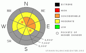
BOTTOM LINE
Danger by aspect and elevation on slopes approaching 35° or steeper.
(click HERE for tomorrow's danger rating)
|
Danger Rose Tutorial
|
With heavy snowfall and continued strong wind in the forecast, the avalanche danger will increase and become more widespread today. Dangerous and deteriorating avalanche conditions will create a level 3 (or CONSIDERABLE) danger. Triggered wind slab and storm snow avalanches are probable in drifted upper elevation terrain. There is a level 2 (MODERATE) danger and avalanches are possible even on more sheltered slopes. Careful snowpack evaluation, cautious route finding and conservative decision-making are essential today....
|
|
|
CURRENT CONDITIONS |

|
The Tony Grove Snotel reports several inches of snow overnight and an inch of water equivalent. The station reports 20 inches of total snow on the ground. Several inches of heavy, drifted snow have now accumulated on top of a zipper rime-crust from Sunday.... The wind sensor at 9700' on Logan Peak reports 50 mph winds from the west this morning and its23 degrees.
As you might expect this time of year, the snow is still very shallow and travel is limited to smooth upper elevation terrain. Backcountry snowmobiling is not happening yet, with both sled and resource damage likely if you venture off roadways.... If you're heading out for some early season turns, remember to keep the speed down and watch carefully for shallowly buried rocks and other obstacles. Heavily forested and south facing slopes were bare last week.. The Tony Grove Road is not maintained for wheeled vehicles in the winter. Expect patches of ice, deepening snow, and deteriorating driving conditions. |
|
|
RECENT ACTIVITY |

|
No recent avalanche activity has been observed in the Logan Area. Too early to tell what Sunday's rime-crust may implicate for the future, but there is certainly potential for future weak layer development in the couple inches of cold light surface snow it just capped... |
|
|
THREAT #1 |

|
| WHERE |
PROBABILITY |
SIZE |
TREND |
|
|
|
|
| |
|
|
Over the next
24 hours.
|
|
|
You will find freshly built wind slabs 1 to 2 feet deep in exposed upper elevation terrain today. These could be sensitive to your weight. Wind slabs usually are found in exposed terrain at the highest elevations and in and around terrain features like gullies, scoops, and cliff bands....
|
|
|
THREAT #2 |

|
| WHERE |
PROBABILITY |
SIZE |
TREND |

|
|
|
|
| |
|
|
Over the next
12 hours.
|
|
|
Strong winds and heavy snowfall are possible today, and the avalanche danger will be on the rise. The danger of storm snow and wind slab avalanches could increase significantly and become more widespread by evening.
Its a good idea to practice with your rescue equipment in the early season.... Shallow, simple problems in snow, or even in urban leaf piles, are recommended. |
|
|
MOUNTAIN WEATHER |

|
The National Weather Service has continued a Winter Storm Warning for the mountains of Northern Utah through 8 pm tonight. Tuesday. Periods of heavy snowfall and very strong winds are forecast for upper elevation terrain.
Looks like warmer and dryer weather for Wednesday through the end of the week, with snow returning by the weekend..... |
|
|
GENERAL ANNOUNCEMENTS |
Don't miss our annual Pray for Snow party and fundraiser, Wednesday December 1st at the Italian Place.
We're offering a free avalanche awareness/ Know Before You Go Talk on Thursday, November 18, 6:00 pm, at the Logan Ranger District Offices, 1500 E. Hwy 89
Send us your avalanche and snow observations. You can also call me at 435-757-7578, or email to uac@utahavalanchecenter.org
Donate to your favorite non-profit – The Friends of the Utah Avalanche Center. The UAC depends on contributions from users like you to support our work.
This advisory is from the U.S.D.A. Forest Service, which is solely responsible for its content. This advisory describes general avalanche conditions and local variations always occur. |
|
|
This information does not apply to developed ski areas or highways where avalanche control is normally done. This advisory is from the U.S.D.A. Forest Service, which is solely responsible for its content. This advisory describes general avalanche conditions and local variations always occur. |
|
This advisory provided by the USDA Forest Service, in partnership with:
The Friends of the Utah Avalanche Center, Utah Division of State Parks and Recreation, Utah Division of Emergency Management, Salt Lake County, Salt Lake Unified Fire Authority and the friends of the La Sal Avalanche Center. See our Sponsors Page for a complete list. |
