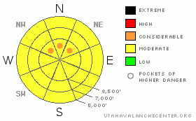
BOTTOM LINE
Danger by aspect and elevation on slopes approaching 35° or steeper.
(click HERE for tomorrow's danger rating)
|
Danger Rose Tutorial
|
There is a MODERATE (2) danger in the backcountry, and heightened avalanche conditions exist. Pockets with a CONSIDERABLE (3) danger may be found in some areas, and you could trigger dangerous large cornice fall or persistent slab avalanches in steep upper elevation terrain exposed to recent wind drifting... Wet avalanche are possible and the danger will increase with daytime warming on any steep slope with soft, moist, or saturated snow...
Evaluate snow and terrain carefully, use conservative decision making, and continue to follow safe travel protocols.... |
|
|
CURRENT CONDITIONS |

|
You can probably find fairly good snow coverage at upper elevations, considering that the Tony Grove Snotel reports 79" inches of total snow on the ground and 74% of average water content. But, you don't want to let your guard down just because it's spring... The CSI weather station on Logan Peak reports a very warm low temperature of 33 degrees this morning, and south winds averaging around 35 mph with gusts in the 50s..
As the snow melts this spring, the areas where you can ride will become limited since you shouldn't ride over bare ground or vegetation. Resource damage can be serious especially in wet ground, and the melt is gradually swelling brooks and water courses while undermining and destroying snow bridges.
|
|
|
RECENT ACTIVITY |

|
A lucky outcome in an incident yesterday in the Western Uintas, when two riders were partially buried by an avalanche triggered by another rider... |
|
|
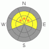
THREAT #1 |

|
| WHERE |
PROBABILITY |
SIZE |
TREND |
|
|
|
|
| |
|
|
Over the next
24
hours.
|
|
|
It's only been a week since Utah's most recent tragic and fatal avalanche accident, which featured a large cornice failure... Here's the problem; strong and continuing winds are building huge overhanging cornices out over steep slopes, while warm daytime temperatures, poor overnight freezes and gravitational pull are causing them to sag and change shape. In these conditions, a person's (or and a machine's) weight might be enough to trigger a big and dangerous cornice fall avalanche.... It is possible if not likely that when the heavy cornice hits the slope below, it will trigger an even more dangerous slab avalanche, as was the case in the mountains above Farmington a week ago. |
|
|
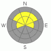
THREAT #2 |

|
| WHERE |
PROBABILITY |
SIZE |
TREND |
|
|
|
|
| |
|
|
Over the next
24
hours.
|
|
|
The skier triggered avalanches from the beginning of the month off Long Mountain and Big Baldy in Providence Canyon showed that areas exist where you could probably still trigger a very dangerous hard slab avalanche.... Lingering buried persistent weak layers made up of sugary or faceted snow have become overloaded by hard wind blown and melt-freeze slab layers.... This type of snow structure can remain unstable for some time, like a spring-loaded mouse trap, only needing a little disturbance to trigger. And, avalanches releasing on persistent faceted weak layers can be triggered from a distance, or worse, from below. |
|
|
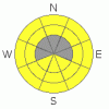
THREAT #3 |

|
| WHERE |
PROBABILITY |
SIZE |
TREND |
|
|
|
|
| |
|
|
Over the next
24
hours.
|
|
|
In the spring, its best to be getting off steep slopes before the heat of midday....
Warmth and melting will cause an increase in the the danger of both threats listed above, and wet avalanches will also become more likely.... Wet point release avalanches, which might entrain large piles in descent will become possible on any steep slope with loose saturated surface snow and wet slabs on slopes with softening poor snow structure. Glide avalanches off very steep smooth slopes or rock slabs could happen any time of day or night even after things cool down |
|
|
MOUNTAIN WEATHER |

|
Looks like exceptionally windy weather will continue through today and tonight and into tomorrow...Very strong south southwest winds will bring another good dusting to the snow surface from the desert...A strong front will pass through he region late tomorrow with some thunder and lightening possible.. 4 to 6 inches may accumulate at upper elevations Monday night and Tuesday morning before things move off to the east. |
|
|
GENERAL ANNOUNCEMENTS |
This will be the last regular advisory for the season.....
Please continue to send in avalanche avalanche and snow observations. You can leave a message at the SLC office at 800-662-4140, or email to uac@utahavalanchecenter.org
Donate to your favorite non-profit – The Friends of the Utah Avalanche Center. The UAC depends on contributions from users like you to support our work.
The information in this advisory is from the U.S. Forest Service, which is solely responsible for its content. This advisory describes general avalanche conditions and local variations always occur. |
|
|
This information does not apply to developed ski areas or highways where avalanche control is normally done. This advisory is from the U.S.D.A. Forest Service, which is solely responsible for its content. This advisory describes general avalanche conditions and local variations always occur. |
|
This advisory provided by the USDA Forest Service, in partnership with:
The Friends of the Utah Avalanche Center, Utah Division of State Parks and Recreation, Utah Division of Emergency Management, Salt Lake County, Salt Lake Unified Fire Authority and the friends of the La Sal Avalanche Center. See our Sponsors Page for a complete list. |
