SPECIAL ANNOUNCEMENT |
 |
We've issued a Special Avalanche Advisory for the Logan and the Western Uinta forecast zones.....Heavy snowfall and strong winds overloaded slopes with buried persistent weak layers in drifted upper elevation terrain... |
|
|
BOTTOM LINE
Danger by aspect and elevation on slopes approaching 35° or steeper.
(click HERE for tomorrow's danger rating)
|
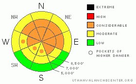
Danger Rose Tutorial
|
There is a CONSIDERABLE (3) danger and dangerous avalanche conditions exist in the backcountry around Logan. You could probably trigger fresh wind slab or dangerous deeper persistent slab avalanches on many drifted upper elevation slopes approaching and steeper than about 35 degrees. Wet avalanches are possible with daytime warming on any steep slope with saturated snow. Forecast strong southwest winds and very heavy snowfall tonight will likely cause the overall danger to rise to HIGH (4) for tomorrow, and dangerous avalanche conditions are likely to persist through the weekend..
Careful snowpack evaluation, cautious route-finding and conservative decision-making are essential for safe backcountry travel today. |
|
|
CURRENT CONDITIONS |

|
You'll find good powder conditions in the backcountry, and there are plenty of untracked sheltered and lower angled slopes where you can find safe conditions and generally stable snow The Tony Grove Snotel reports a storm total about 18" of new snow containing 1.5 inches of water. The station reports 76" of total snow with 65% of average water for the date. More heavy snowfall and increasing southwest winds are forecast for tonight. Its a chilly 10 degrees up at the CSI Logan Peak weather station at 9700' and the wind sensor is apparently rimed... Strong southwest winds forecast for tonight will probably take care of this problem.... |
|
|
RECENT ACTIVITY |

|
A rider on a powder-surf board triggered a soft wind slab avalanche (12-18" deep and 50' wide) and was then caught and carried over rocks in steep terrain west of Tony Grove Lake on Saturday (3-27-10).
Separate parties of skiers each remote triggered large and destructive hard slab avalanches on the south side of Providence Canyon yesterday (4-1-10)... Both avalanches on generally north facing drifted slopes at around 9000' in elevation involved several layers of very hard old snow and failed on persistent weak layers consisting of sugary, faceted snow...
Here's an updated local backcountry avalanche list:
|
|
|
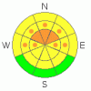
THREAT #1 |

|
| WHERE |
PROBABILITY |
SIZE |
TREND |
|
|
|
|
| |
|
|
Over the next
24 hours.
|
|
|
The two large triggered persistent slab avalanches up in Providence Canyon on Thursday (4-1-10) prove that this problem is still real in our region..... Slopes with weak (and generally shallow) snow structure can be found in many areas.... On slopes with significant recent deposits of wind drifted snow, slabs overloading layers of sugary weak snow have apparently become heavy and hard enough to fail....
You might trigger a deep or persistent slab avalanche from a distance, or worse, from below.... |
|
|
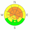
THREAT #2 |

|
| WHERE |
PROBABILITY |
SIZE |
TREND |
|
|
|
|
| |
|
|
Over the next
12 hours.
|
|
|
Watch out for fresh or buried wind slabs near ridge tops, around rock outcroppings or cliffy areas, near sub-ridges and in gullies or scoops. Today's wind slabs will not necessarily be obvious and you should use caution in complex terrain... Even shallow or soft wind slabs or storm snow avalanches could be a problem if you get caught and carried into trees or other terrain traps below....
Storm snow and wind slab avalanches are possible this morning and the danger is likely to rise tonight, with significantly more snow and intensifying southwest winds likely. Storm snow avalanches may fail on weak layers or density differences within the new snow. Natural avalanches involving the new snow probably will occur tonight during periods of intense heavy snowfall or with sustained wind drifting... |
|
|
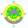
THREAT #3 |

|
| WHERE |
PROBABILITY |
SIZE |
TREND |
|
|
|
|
| |
|
|
Over the next
24
hours.
|
|
|
The saturated snow at lower and mid elevations was insulated by the new snow and it's still soft and punchy on some steep slopes... Wet avalanches are possible in these areas even when the air temperature is cool....
Solar or seasonal warming will cause a rapid increase in the danger of loose wet avalanches involving the fresh snow... Point release avalanches may entrain significant quantities of moist surface snow, and could gouge into older snow.... |
|
|
MOUNTAIN WEATHER |

|
Snow showers will continue in the mountains today and temperatures should stay fairly cool... A west wind will increase to around 20 mph today, and little accumulation is expected. Southwest winds will intensify and be quite strong tonight and we'll be hit hard by a quick hitting but powerful storm. Winds could gust into the 50s and 10 to 14 inches of accumulation is forecast... The National Weather Service has issued a Winter Storm Watch for the mountains of Northern Utah for tonight through midday tomorrow. |
|
|
GENERAL ANNOUNCEMENTS |
Send us your avalanche and snow observations. You can call the SLC office at 800-662-4140, or email to uac@utahavalanchecenter.org
Donate to your favorite non-profit – The Friends of the Utah Avalanche Center. The UAC depends on contributions from users like you to support our work.
The information in this advisory is from the U.S. Forest Service, which is solely responsible for its content. This advisory describes general avalanche conditions and local variations always occur.
With limited funding available, we'll go to weekend and intermittent updates in April. Thanks for checking in.... |
|
|
This information does not apply to developed ski areas or highways where avalanche control is normally done. This advisory is from the U.S.D.A. Forest Service, which is solely responsible for its content. This advisory describes general avalanche conditions and local variations always occur. |
|
This advisory provided by the USDA Forest Service, in partnership with:
The Friends of the Utah Avalanche Center, Utah Division of State Parks and Recreation, Utah Division of Emergency Management, Salt Lake County, Salt Lake Unified Fire Authority and the friends of the La Sal Avalanche Center. See our Sponsors Page for a complete list. |
